Property Record
6500 Bridge Rd, Monona, WI 53713


Save to a Folder
{{folder.Name}}
{{folder.ListingIds.length}} Properties
{{folder.ListingIds.length}} Property
Create a New Folder
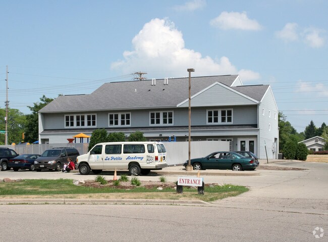
Property Detail
6500 Bridge Rd
Madison, WI
PRT LOT 1 CSM 3059 CS12/56-58 DESCR AS SEC 29-7-10 PRT NW1/4 & PRT LOT 15 SOUTH TOWNE PLAT COM AT NE COR SD LOT 1 TH N89DEG3940W 62.67 FT TO POB TH S00DEG202 0W 210.00 FT TH N89DEG3940W 163.33 FT TH NWLY ON CRV TO R RAD 25.00 FT L/C N8 3DEG5333W 5.03
0710-292-2030-3
Dane
Commercialnec
Wisconsin
B and X Area of moderate flood hazard, usually the area between the limits of the 100-year and 500-year floods.
1,15
2025
0.81 AC
2025
Southeast Madison
001502
Milwaukee/Madison
NEARBY LISTINGS FOR SALE OR LEASE
DEMOGRAPHICS near 6500 Bridge Rd
1 mile
3 mile
5 mile
2025 Total Population
6,346
44,670
212,890
2030 Population
6,600
46,482
226,876
Pop Growth 2025-2030
+ 4.00%
+ 4.06%
+ 6.57%
Average Age
42
40
36
2025 Total Households
2,954
21,417
94,705
HH Growth 2025-2030
+ 4.37%
+ 4.35%
+ 6.94%
Median Household Inc
$80,263
$74,924
$67,406
Avg Household Size
2.10
2.00
2.10
2025 Avg HH Vehicles
2.00
2.00
1.00
Median Home Value
$384,402
$356,558
$371,646
Median Year Built
1969
1970
1983
Nearby Places
Map Layers
Map Styles
 Street
 Aerial
Layers
 Traffic
 Biking
Places
Listings with unknown addresses are not visible on the map
- Restaurants
- Banks
- Shops
- Fitness
- Groceries
PUBLIC TRANSPORTATION
AIRPORT
Dane County Regional/Truax Field
Drive
Walk
Distance
Dane County Regional/Truax Field
18 min
9.8 mi
Nearby Properties
Address
Land Use
TOTAL SIZE
Lot Size
Zoning
Address
Land Use
TOTAL SIZE
Lot Size
Zoning
188,206 SF
0.80 AC
UMX
Address
Land Use
TOTAL SIZE
Lot Size
Zoning
158,832 SF
0.58 AC
WP-17
Address
Land Use
TOTAL SIZE
Lot Size
Zoning
403,079 SF
1.08 AC
WP-17
Address
Land Use
TOTAL SIZE
Lot Size
Zoning
412,945 SF
1.30 AC
WP-17
Address
Land Use
TOTAL SIZE
Lot Size
Zoning
145,539 SF
0.60 AC
UMX
Address
Land Use
TOTAL SIZE
Lot Size
Zoning
230,007 SF
0.76 AC
PD
Address
Land Use
TOTAL SIZE
Lot Size
Zoning
268,388 SF
1 AC
WP-24
Address
Land Use
TOTAL SIZE
Lot Size
Zoning
168,685 SF
14.05 AC
IL
Address
Land Use
TOTAL SIZE
Lot Size
Zoning
2.97 AC
Address
Land Use
TOTAL SIZE
Lot Size
Zoning
425,812 SF
1 AC
WP-17
Address
Land Use
TOTAL SIZE
Lot Size
Zoning
20,965 SF
10.98 AC
IL
Address
Land Use
TOTAL SIZE
Lot Size
Zoning
13.40 AC
Address
Land Use
TOTAL SIZE
Lot Size
Zoning
137,835 SF
1.49 AC
WP-17
Address
Land Use
TOTAL SIZE
Lot Size
Zoning
169,491 SF
0.79 AC
PD
Address
Land Use
TOTAL SIZE
Lot Size
Zoning
2.03 AC
Address
Land Use
TOTAL SIZE
Lot Size
Zoning
169,326 SF
0.37 AC
WP-17
Address
Land Use
TOTAL SIZE
Lot Size
Zoning
148,747 SF
0.83 AC
WP-24
Address
Land Use
TOTAL SIZE
Lot Size
Zoning
3.59 AC
Address
Land Use
TOTAL SIZE
Lot Size
Zoning
128,676 SF
1.66 AC
PD
Address
Land Use
TOTAL SIZE
Lot Size
Zoning
156,054 SF
9.40 AC
SE
Address
Land Use
TOTAL SIZE
Lot Size
Zoning
2.38 AC
Address
Land Use
TOTAL SIZE
Lot Size
Zoning
172,052 SF
4.09 AC
SE
Address
Land Use
TOTAL SIZE
Lot Size
Zoning
77,504 SF
0.50 AC
WP-24
Address
Land Use
TOTAL SIZE
Lot Size
Zoning
99,697 SF
0.33 AC
WP-17
Address
Land Use
TOTAL SIZE
Lot Size
Zoning
124,648 SF
0.37 AC
PD
Address
Land Use
TOTAL SIZE
Lot Size
Zoning
21.92 AC
Address
Land Use
TOTAL SIZE
Lot Size
Zoning
5.53 AC
Address
Land Use
TOTAL SIZE
Lot Size
Zoning
14,058 SF
0.60 AC
WP-17
Address
Land Use
TOTAL SIZE
Lot Size
Zoning
4.56 AC
B-1
Address
Land Use
TOTAL SIZE
Lot Size
Zoning
85,180 SF
0.86 AC
UMX
The World's #1 Commercial Real Estate Marketplace
Connect with us
© 2026 CoStar Group
The information above has been obtained from sources believed reliable. While we do not doubt its accuracy we have not verified it and make no guarantee, warranty or representation about it. It is your responsibility to independently confirm its accuracy and completeness. Any projections, opinions, assumptions, or estimates used are for example only and do not represent the current or future performance of the property. The value of this transaction to you depends on tax and other factors which should be evaluated by your tax, financial, and legal advisors. You and your advisors should conduct a careful, independent investigation of the property to determine to your satisfaction the suitability of the property for your needs.