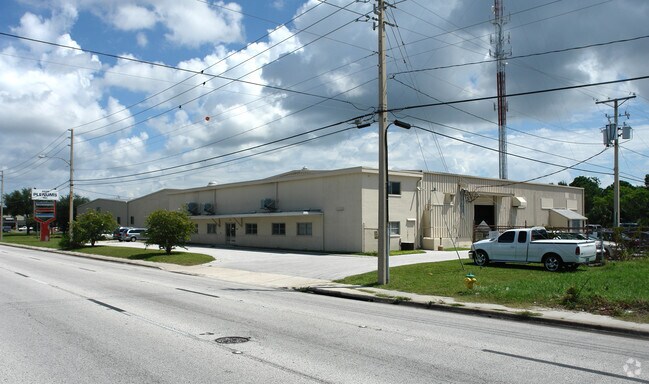
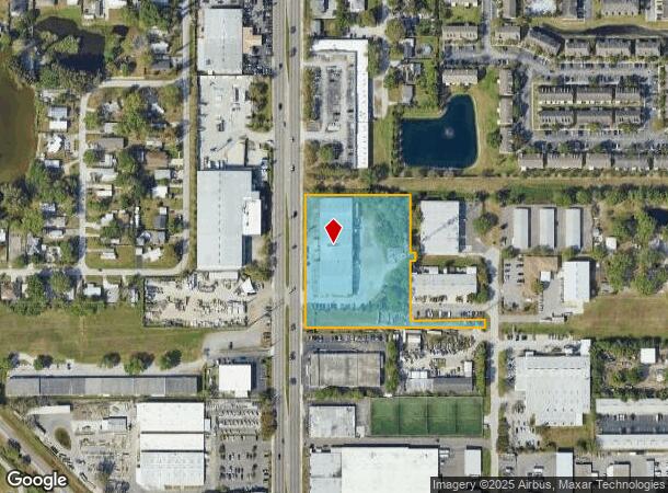
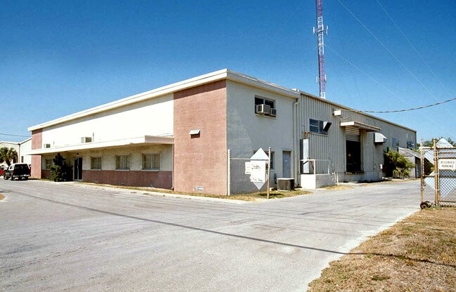
Property Record
6501 49Th St N, Pinellas Park, FL 33781
NEARBY LISTINGS FOR SALE OR LEASE
Property Detail
6501 49Th St N
33-30-16-69948-100-1801
Pinellas Farms
Lightindustrial
PINELLAS FARMS NE 1/4, SEC 33-30-16 PART OF FARM 18 DESC AS BEG SW COR 6500 47TH ST N CONDO TH E 237FT TH S 24FT (S) TH W 570.13 FT TH N 420FT TH E 333.13 FT TH S 183.1FT TH E 18FT TH S 24.4FT TH W 18FT TH S 188FT TO POB
AE
Pinellas
12103C0204H
Florida
2024
3.34 AC
2025
South Pinellas
024908
Tampa/St Petersburg
34,300 SF
Tampa-St. Petersburg-Clearwater, FL
DEMOGRAPHICS near 6501 49Th St N
1 Mile
3 Mile
5 Mile
2024 Total Population
12,391
119,782
274,139
2029 Population
12,403
119,899
274,673
Pop Growth 2024-2029
+ 0.10%
+ 0.10%
+ 0.19%
Average Age
41
44
44
2024 Total Households
5,092
51,675
123,858
HH Growth 2024-2029
(0.06%)
+ 0.05%
+ 0.04%
Median Household Inc
$48,459
$54,062
$60,782
Avg Household Size
2.30
2.20
2.10
2024 Avg HH Vehicles
2.00
2.00
2.00
Median Home Value
$213,712
$209,143
$243,173
Median Year Built
1972
1970
1971
Nearby Places
Map Layers
Map Styles
 Street
 Aerial
- Restaurants
- Banks
- Shops
- Fitness
- Groceries
PUBLIC TRANSPORTATION
AIRPORT
St Pete-Clearwater International
DRIVE
WALK
Distance
St Pete-Clearwater International
18 min
7.8 mi
Tampa International
DRIVE
WALK
Distance
Tampa International
28 min
18.0 mi
Freight Ports
Port Manatee
DRIVE
WALK
Distance
Port Manatee
42 min
30.7 mi
Nearby Properties
Address
Land Use
TOTAL SIZE
Lot Size
Zoning
Address
Land Use
TOTAL SIZE
Lot Size
Zoning
459,848 SF
19.74 AC
R6
Address
Land Use
TOTAL SIZE
Lot Size
Zoning
372,013 SF
10.10 AC
Address
Land Use
TOTAL SIZE
Lot Size
Zoning
447,664 SF
34.44 AC
Address
Land Use
TOTAL SIZE
Lot Size
Zoning
346,420 SF
17.95 AC
Address
Land Use
TOTAL SIZE
Lot Size
Zoning
372,436 SF
22.30 AC
Address
Land Use
TOTAL SIZE
Lot Size
Zoning
404,063 SF
12.98 AC
Address
Land Use
TOTAL SIZE
Lot Size
Zoning
404,899 SF
35.35 AC
Address
Land Use
TOTAL SIZE
Lot Size
Zoning
358,681 SF
11.70 AC
Address
Land Use
TOTAL SIZE
Lot Size
Zoning
240,736 SF
58.40 AC
Address
Land Use
TOTAL SIZE
Lot Size
Zoning
402,681 SF
18.40 AC
Address
Land Use
TOTAL SIZE
Lot Size
Zoning
324,579 SF
16.97 AC
Address
Land Use
TOTAL SIZE
Lot Size
Zoning
309,526 SF
36.85 AC
C2
Address
Land Use
TOTAL SIZE
Lot Size
Zoning
300,546 SF
6.49 AC
Address
Land Use
TOTAL SIZE
Lot Size
Zoning
423,776 SF
20.91 AC
Address
Land Use
TOTAL SIZE
Lot Size
Zoning
170,146 SF
17.78 AC
Address
Land Use
TOTAL SIZE
Lot Size
Zoning
206,685 SF
16.75 AC
RPD5
Address
Land Use
TOTAL SIZE
Lot Size
Zoning
267,649 SF
17.86 AC
Address
Land Use
TOTAL SIZE
Lot Size
Zoning
258,722 SF
11.04 AC
Address
Land Use
TOTAL SIZE
Lot Size
Zoning
281,993 SF
85.13 AC
Address
Land Use
TOTAL SIZE
Lot Size
Zoning
193,194 SF
13.53 AC
Address
Land Use
TOTAL SIZE
Lot Size
Zoning
360,137 SF
37.64 AC
AE
Address
Land Use
TOTAL SIZE
Lot Size
Zoning
172,600 SF
20.57 AC
Address
Land Use
TOTAL SIZE
Lot Size
Zoning
172,768 SF
15.05 AC
RPD20
Address
Land Use
TOTAL SIZE
Lot Size
Zoning
99,116 SF
20.60 AC
Address
Land Use
TOTAL SIZE
Lot Size
Zoning
125,218 SF
13.51 AC
Address
Land Use
TOTAL SIZE
Lot Size
Zoning
88,793 SF
13.78 AC
IL
Address
Land Use
TOTAL SIZE
Lot Size
Zoning
113,365 SF
13.32 AC
Address
Land Use
TOTAL SIZE
Lot Size
Zoning
226,561 SF
24.34 AC
Address
Land Use
TOTAL SIZE
Lot Size
Zoning
116,358 SF
12.74 AC
Address
Land Use
TOTAL SIZE
Lot Size
Zoning
248,572 SF
15.22 AC
PSP
The World's #1 Commercial Real Estate Marketplace
Connect with us
© 2025 CoStar Group
The information above has been obtained from sources believed reliable. While we do not doubt its accuracy we have not verified it and make no guarantee, warranty or representation about it. It is your responsibility to independently confirm its accuracy and completeness. Any projections, opinions, assumptions, or estimates used are for example only and do not represent the current or future performance of the property. The value of this transaction to you depends on tax and other factors which should be evaluated by your tax, financial, and legal advisors. You and your advisors should conduct a careful, independent investigation of the property to determine to your satisfaction the suitability of the property for your needs.