Property Record
6501 N Brown Station Rd, Columbia, MO 65202
NEARBY LISTINGS FOR SALE OR LEASE
-
-
View all Columbia listings for sale on LoopNet.com
Property Detail
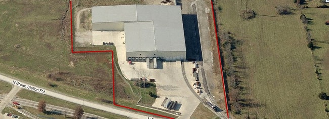
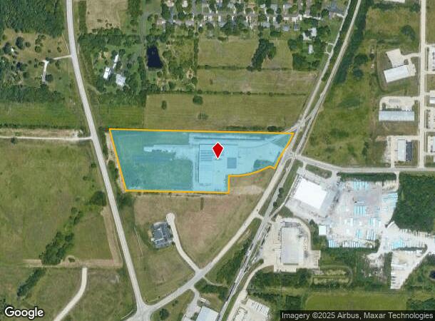
6501 N Brown Station Rd
12-503-00-12-001-00-01
B And B Crossings
Truckterminal
B AND B CROSSINGS PLAT 1 LOT 1
X
Boone
29019C0169E
Missouri
0
1
2025
14.96 AC
001506
Other Market Areas
83,100 SF
Columbia, MO
DEMOGRAPHICS near 6501 N Brown Station Rd
1 Mile
3 Mile
5 Mile
2024 Total Population
972
14,556
47,358
2029 Population
1,054
15,496
50,392
Pop Growth 2024-2029
+ 8.44%
+ 6.46%
+ 6.41%
Average Age
36
37
37
2024 Total Households
403
5,654
19,410
HH Growth 2024-2029
+ 8.68%
+ 6.60%
+ 6.54%
Median Household Inc
$73,749
$65,003
$62,058
Avg Household Size
2.40
2.50
2.40
2024 Avg HH Vehicles
2.00
2.00
2.00
Median Home Value
$193,014
$175,289
$177,981
Median Year Built
2003
1994
1994
Nearby Places
Map Layers
Map Styles
 Street
 Aerial
- Restaurants
- Banks
- Shops
- Fitness
- Groceries
PUBLIC TRANSPORTATION
AIRPORT
Columbia Regional
DRIVE
WALK
Distance
Columbia Regional
22 min
17.0 mi
Nearby Properties
Address
Land Use
TOTAL SIZE
Lot Size
Zoning
Address
Land Use
TOTAL SIZE
Lot Size
Zoning
12.55 AC
A1
Address
Land Use
TOTAL SIZE
Lot Size
Zoning
321,295 SF
79.83 AC
Address
Land Use
TOTAL SIZE
Lot Size
Zoning
134,760 SF
103.42 AC
Address
Land Use
TOTAL SIZE
Lot Size
Zoning
101,072 SF
Address
Land Use
TOTAL SIZE
Lot Size
Zoning
259,538 SF
26.78 AC
M1
Address
Land Use
TOTAL SIZE
Lot Size
Zoning
56,305 SF
12 AC
CP
Address
Land Use
TOTAL SIZE
Lot Size
Zoning
151,550 SF
53.69 AC
MC
Address
Land Use
TOTAL SIZE
Lot Size
Zoning
167,255 SF
14.14 AC
Address
Land Use
TOTAL SIZE
Lot Size
Zoning
5,200 SF
11 AC
M1
Address
Land Use
TOTAL SIZE
Lot Size
Zoning
117,114 SF
7.66 AC
Address
Land Use
TOTAL SIZE
Lot Size
Zoning
60,000 SF
6.91 AC
Address
Land Use
TOTAL SIZE
Lot Size
Zoning
172,056 SF
31.81 AC
MC
Address
Land Use
TOTAL SIZE
Lot Size
Zoning
58,200 SF
14.68 AC
MC
Address
Land Use
TOTAL SIZE
Lot Size
Zoning
21,120 SF
7.71 AC
Address
Land Use
TOTAL SIZE
Lot Size
Zoning
80,256 SF
10.10 AC
M1
Address
Land Use
TOTAL SIZE
Lot Size
Zoning
20,740 SF
2.75 AC
MC
Address
Land Use
TOTAL SIZE
Lot Size
Zoning
29,527 SF
3.56 AC
CP
Address
Land Use
TOTAL SIZE
Lot Size
Zoning
45,144 SF
19.47 AC
M1
Address
Land Use
TOTAL SIZE
Lot Size
Zoning
23,945 SF
7.51 AC
MLP
Address
Land Use
TOTAL SIZE
Lot Size
Zoning
30,020 SF
22.05 AC
Address
Land Use
TOTAL SIZE
Lot Size
Zoning
33,460 SF
3.78 AC
Address
Land Use
TOTAL SIZE
Lot Size
Zoning
14,250 SF
2.96 AC
R1
Address
Land Use
TOTAL SIZE
Lot Size
Zoning
31,000 SF
8.90 AC
M1
Address
Land Use
TOTAL SIZE
Lot Size
Zoning
37,985 SF
6.84 AC
ML
Address
Land Use
TOTAL SIZE
Lot Size
Zoning
51,615 SF
6.25 AC
Address
Land Use
TOTAL SIZE
Lot Size
Zoning
31,925 SF
3.29 AC
Address
Land Use
TOTAL SIZE
Lot Size
Zoning
9,108 SF
2.38 AC
Address
Land Use
TOTAL SIZE
Lot Size
Zoning
45,000 SF
4.08 AC
M1
Address
Land Use
TOTAL SIZE
Lot Size
Zoning
12,000 SF
4.47 AC
The World's #1 Commercial Real Estate Marketplace
Connect with us
© 2026 CoStar Group
The information above has been obtained from sources believed reliable. While we do not doubt its accuracy we have not verified it and make no guarantee, warranty or representation about it. It is your responsibility to independently confirm its accuracy and completeness. Any projections, opinions, assumptions, or estimates used are for example only and do not represent the current or future performance of the property. The value of this transaction to you depends on tax and other factors which should be evaluated by your tax, financial, and legal advisors. You and your advisors should conduct a careful, independent investigation of the property to determine to your satisfaction the suitability of the property for your needs.