Property Record
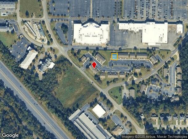
6501 Peake Rd, Macon, GA 31210
NEARBY LISTINGS FOR SALE OR LEASE
-
-
View all Macon listings for lease on LoopNet.com
Property Detail
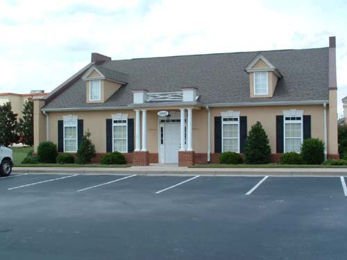
6501 Peake Rd
Atlanta
Southern Pine Plantations Of
Macon-Bibb County, GA
PLANTATION CENTRE
I005-0547
Bibb
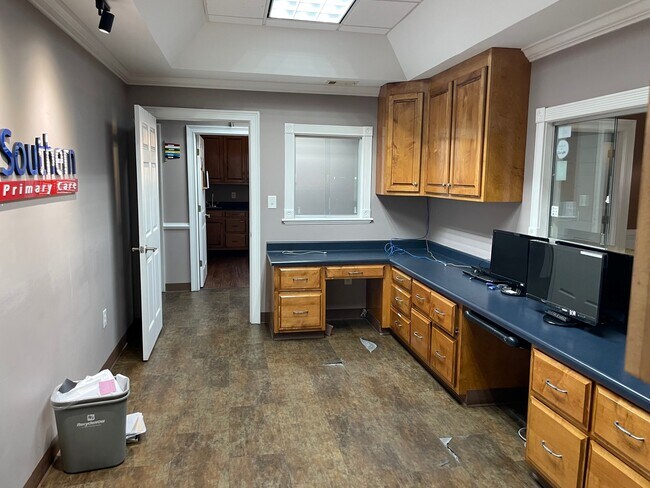
Medicalbuilding
Georgia
2025
10
2025
0.11 AC
013412
Outlying Bibb County
2,592 SF
DEMOGRAPHICS near 6501 Peake Rd
1 Mile
3 Mile
5 Mile
2024 Total Population
4,942
19,140
55,337
2029 Population
4,829
18,639
54,582
Pop Growth 2024-2029
(2.29%)
(2.62%)
(1.36%)
Average Age
41
41
40
2024 Total Households
1,956
7,618
22,973
HH Growth 2024-2029
(2.10%)
(2.55%)
(1.42%)
Median Household Inc
$70,779
$89,849
$71,849
Avg Household Size
2.40
2.40
2.40
2024 Avg HH Vehicles
2.00
2.00
2.00
Median Home Value
$225,806
$230,841
$210,531
Median Year Built
1995
1992
1989
Nearby Places
Map Layers
Map Styles
 Street
 Aerial
- Restaurants
- Banks
- Shops
- Fitness
- Groceries
SALE & LEASE HISTORY
LISTING DATE
SALE/LEASE

Nov 14, 2022
For Lease
May 26, 2020
For Lease
Jan 30, 2020
For Lease
Jan 30, 2020
For Sale
Feb 21, 2023
For Lease
Nearby Properties
Address
Land Use
TOTAL SIZE
Lot Size
Zoning
Address
Land Use
TOTAL SIZE
Lot Size
Zoning
Address
Land Use
TOTAL SIZE
Lot Size
Zoning
24,207 SF
21.84 AC
PDE
Address
Land Use
TOTAL SIZE
Lot Size
Zoning
83,104 SF
20.39 AC
PDE
Address
Land Use
TOTAL SIZE
Lot Size
Zoning
5,684 SF
29.99 AC
PDE
Address
Land Use
TOTAL SIZE
Lot Size
Zoning
22,421 SF
13.60 AC
PDE
Address
Land Use
TOTAL SIZE
Lot Size
Zoning
98,912 SF
13.95 AC
PDE
Address
Land Use
TOTAL SIZE
Lot Size
Zoning
59,801 SF
28.03 AC
PDE
Address
Land Use
TOTAL SIZE
Lot Size
Zoning
5,270 SF
20 AC
Address
Land Use
TOTAL SIZE
Lot Size
Zoning
61,540 SF
130.80 AC
A
Address
Land Use
TOTAL SIZE
Lot Size
Zoning
214,685 SF
18.69 AC
C-2
Address
Land Use
TOTAL SIZE
Lot Size
Zoning
51,786 SF
21.05 AC
PDR
Address
Land Use
TOTAL SIZE
Lot Size
Zoning
20,544 SF
62.02 AC
A
Address
Land Use
TOTAL SIZE
Lot Size
Zoning
2,070 SF
24.17 AC
PDR
Address
Land Use
TOTAL SIZE
Lot Size
Zoning
3,025 SF
23.37 AC
R-3
Address
Land Use
TOTAL SIZE
Lot Size
Zoning
4,030 SF
11.99 AC
A
Address
Land Use
TOTAL SIZE
Lot Size
Zoning
211,781 SF
22.45 AC
PDE
Address
Land Use
TOTAL SIZE
Lot Size
Zoning
29,277 SF
15.01 AC
PDE
Address
Land Use
TOTAL SIZE
Lot Size
Zoning
135,820 SF
20 AC
PDE
Address
Land Use
TOTAL SIZE
Lot Size
Zoning
3,600 SF
24.71 AC
R-1AAA
Address
Land Use
TOTAL SIZE
Lot Size
Zoning
10,500 SF
11.21 AC
PDE
Address
Land Use
TOTAL SIZE
Lot Size
Zoning
2,856 SF
20.50 AC
A
Address
Land Use
TOTAL SIZE
Lot Size
Zoning
67,883 SF
9.11 AC
PDE
Address
Land Use
TOTAL SIZE
Lot Size
Zoning
88,509 SF
10.61 AC
PDE
Address
Land Use
TOTAL SIZE
Lot Size
Zoning
62,676 SF
8.57 AC
PDE
Address
Land Use
TOTAL SIZE
Lot Size
Zoning
76,091 SF
36.14 AC
A
Address
Land Use
TOTAL SIZE
Lot Size
Zoning
54,465 SF
3.52 AC
PDE
Address
Land Use
TOTAL SIZE
Lot Size
Zoning
45,807 SF
6.50 AC
PDR
Address
Land Use
TOTAL SIZE
Lot Size
Zoning
15,040 SF
7.88 AC
PDE
Address
Land Use
TOTAL SIZE
Lot Size
Zoning
41,385 SF
166 AC
R-1AAA
Address
Land Use
TOTAL SIZE
Lot Size
Zoning
38,030 SF
5.27 AC
PDE
The World's #1 Commercial Real Estate Marketplace
Connect with us
© 2025 CoStar Group
The information above has been obtained from sources believed reliable. While we do not doubt its accuracy we have not verified it and make no guarantee, warranty or representation about it. It is your responsibility to independently confirm its accuracy and completeness. Any projections, opinions, assumptions, or estimates used are for example only and do not represent the current or future performance of the property. The value of this transaction to you depends on tax and other factors which should be evaluated by your tax, financial, and legal advisors. You and your advisors should conduct a careful, independent investigation of the property to determine to your satisfaction the suitability of the property for your needs.