Property Record
6501 Weston Pky, Cary, NC 27513

Current Lease Availabilities
NEARBY LISTINGS FOR SALE OR LEASE
Property Detail
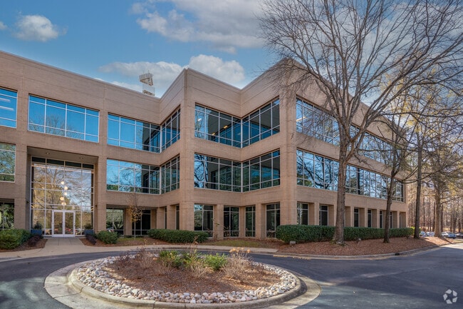
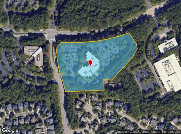
6501 Weston Pky
0765.01-26-3421-000
6501 Weston Pkwy
Officebuilding
BOUNDARY SURVEY 6501 WEST PK BM1994-1877
X
Wake
3720076500K
North Carolina
2025
8.52 AC
2025
Cary
053512
Raleigh/Durham
92,400 SF
Raleigh, NC
DEMOGRAPHICS near 6501 Weston Pky
1 Mile
3 Mile
5 Mile
2024 Total Population
6,284
46,635
167,740
2029 Population
6,827
50,764
182,180
Pop Growth 2024-2029
+ 8.64%
+ 8.85%
+ 8.61%
Average Age
39
38
38
2024 Total Households
3,041
19,493
69,904
HH Growth 2024-2029
+ 8.55%
+ 8.81%
+ 8.59%
Median Household Inc
$102,104
$98,806
$96,996
Avg Household Size
2.00
2.30
2.30
2024 Avg HH Vehicles
2.00
2.00
2.00
Median Home Value
$454,524
$410,325
$410,279
Median Year Built
1996
1996
1997
Nearby Places
Map Layers
Map Styles
 Street
 Aerial
- Restaurants
- Banks
- Shops
- Fitness
- Groceries
PUBLIC TRANSPORTATION
COMMUTER RAIL
Cary Station (Piedmont - North Carolina by Train (NC Train))
DRIVE
WALK
Distance
Cary Station (Piedmont - North Carolina by Train (NC Train))
9 min
4.1 mi
Raleigh Union Station (Piedmont - North Carolina by Train (NC Train))
DRIVE
WALK
Distance
Raleigh Union Station (Piedmont - North Carolina by Train (NC Train))
18 min
9.8 mi
AIRPORT
Raleigh-Durham International
DRIVE
WALK
Distance
Raleigh-Durham International
13 min
5.8 mi
Nearby Properties
Address
Land Use
TOTAL SIZE
Lot Size
Zoning
Address
Land Use
TOTAL SIZE
Lot Size
Zoning
3,672,648 SF
4,584.26 AC
AD-2
Address
Land Use
TOTAL SIZE
Lot Size
Zoning
237,537 SF
24.60 AC
C-BAC
Address
Land Use
TOTAL SIZE
Lot Size
Zoning
949,404 SF
26.71 AC
OIP
Address
Land Use
TOTAL SIZE
Lot Size
Zoning
416,361 SF
38.41 AC
ORD
Address
Land Use
TOTAL SIZE
Lot Size
Zoning
429,107 SF
13.67 AC
RMFP
Address
Land Use
TOTAL SIZE
Lot Size
Zoning
375,689 SF
32.73 AC
HDR
Address
Land Use
TOTAL SIZE
Lot Size
Zoning
312,475 SF
21.74 AC
RMFP
Address
Land Use
TOTAL SIZE
Lot Size
Zoning
312,088 SF
12.53 AC
BAC-G
Address
Land Use
TOTAL SIZE
Lot Size
Zoning
453,970 SF
41.48 AC
RMF-C
Address
Land Use
TOTAL SIZE
Lot Size
Zoning
554,316 SF
42.79 AC
ORD
Address
Land Use
TOTAL SIZE
Lot Size
Zoning
358,137 SF
22.39 AC
RMFP
Address
Land Use
TOTAL SIZE
Lot Size
Zoning
300,662 SF
12.68 AC
BAC-G
Address
Land Use
TOTAL SIZE
Lot Size
Zoning
414,214 SF
11.23 AC
OIP
Address
Land Use
TOTAL SIZE
Lot Size
Zoning
444,236 SF
8.51 AC
ORDP
Address
Land Use
TOTAL SIZE
Lot Size
Zoning
269,702 SF
14.66 AC
GCM
Address
Land Use
TOTAL SIZE
Lot Size
Zoning
368,195 SF
32.11 AC
HDR
Address
Land Use
TOTAL SIZE
Lot Size
Zoning
408,968 SF
32.58 AC
HDR
Address
Land Use
TOTAL SIZE
Lot Size
Zoning
394,181 SF
28.62 AC
HDR
Address
Land Use
TOTAL SIZE
Lot Size
Zoning
266,419 SF
77.78 AC
RA
Address
Land Use
TOTAL SIZE
Lot Size
Zoning
263,094 SF
36.79 AC
ORD
Address
Land Use
TOTAL SIZE
Lot Size
Zoning
513,738 SF
35.66 AC
OIP
Address
Land Use
TOTAL SIZE
Lot Size
Zoning
261,061 SF
18.75 AC
HDR
Address
Land Use
TOTAL SIZE
Lot Size
Zoning
579,364 SF
32.23 AC
IM
Address
Land Use
TOTAL SIZE
Lot Size
Zoning
242,305 SF
48.57 AC
R40
Address
Land Use
TOTAL SIZE
Lot Size
Zoning
226,107 SF
18.72 AC
RMFP
Address
Land Use
TOTAL SIZE
Lot Size
Zoning
330,232 SF
18.45 AC
OIP
Address
Land Use
TOTAL SIZE
Lot Size
Zoning
287,626 SF
14.61 AC
MUPD
Address
Land Use
TOTAL SIZE
Lot Size
Zoning
230,165 SF
10.39 AC
OI
Address
Land Use
TOTAL SIZE
Lot Size
Zoning
293,944 SF
8.89 AC
RMFP
Address
Land Use
TOTAL SIZE
Lot Size
Zoning
283,799 SF
32.70 AC
RMFP
The World's #1 Commercial Real Estate Marketplace
Connect with us
© 2026 CoStar Group
The information above has been obtained from sources believed reliable. While we do not doubt its accuracy we have not verified it and make no guarantee, warranty or representation about it. It is your responsibility to independently confirm its accuracy and completeness. Any projections, opinions, assumptions, or estimates used are for example only and do not represent the current or future performance of the property. The value of this transaction to you depends on tax and other factors which should be evaluated by your tax, financial, and legal advisors. You and your advisors should conduct a careful, independent investigation of the property to determine to your satisfaction the suitability of the property for your needs.