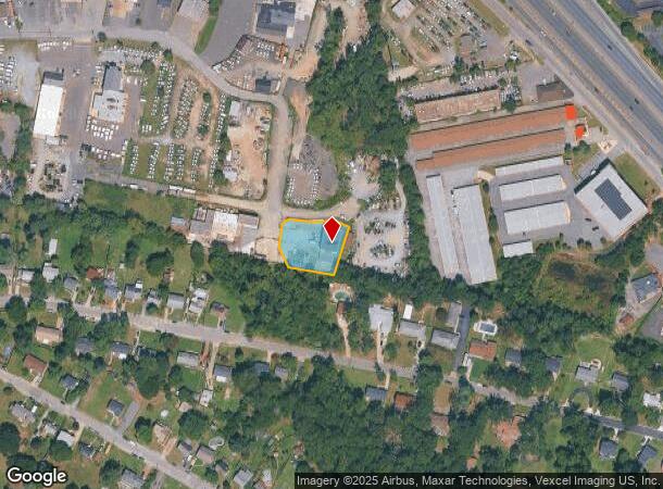
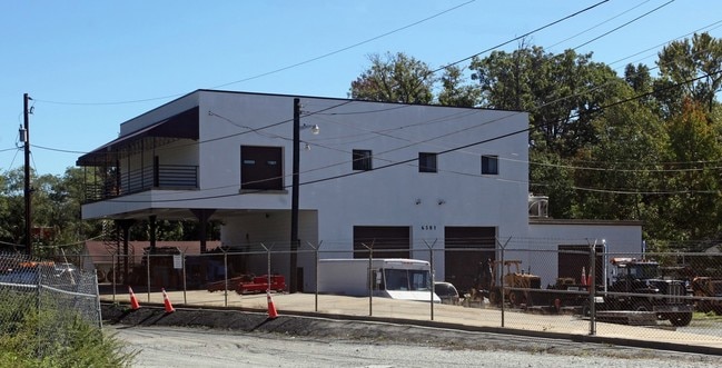
Property Record
6501 Yochelson Pl, Clinton, MD 20735


NEARBY LISTINGS FOR SALE OR LEASE
Property Detail
6501 Yochelson Pl
Washington-Arlington-Alexandria, DC-VA-MD-WV
Yochelson Subdivision
09-0958033
LT 18 & 4271 SF ABND ST VACATED PGCPB 88-283 PET NO V-87292
Loftbuilding
Prince George's
X
Maryland
24033C0245E
18
2024
0.64 AC
2025
Branch Ave Corridor
801211
Washington, DC
8,464 SF
DEMOGRAPHICS near 6501 Yochelson Pl
1 Mile
3 Mile
5 Mile
2024 Total Population
6,429
50,273
150,938
2029 Population
6,239
48,913
146,909
Pop Growth 2024-2029
(2.96%)
(2.71%)
(2.67%)
Average Age
43
43
41
2024 Total Households
2,362
17,302
56,448
HH Growth 2024-2029
(3.18%)
(2.84%)
(2.75%)
Median Household Inc
$103,631
$110,453
$96,004
Avg Household Size
2.70
2.80
2.60
2024 Avg HH Vehicles
2.00
2.00
2.00
Median Home Value
$356,189
$374,952
$367,242
Median Year Built
1983
1979
1978
Nearby Places
Map Layers
Map Styles
 Street
 Aerial
- Restaurants
- Banks
- Shops
- Fitness
- Groceries
PUBLIC TRANSPORTATION
AIRPORT
Ronald Reagan Washington Ntl
DRIVE
WALK
Distance
Ronald Reagan Washington Ntl
30 min
16.7 mi
Baltimore/Washington International Thurgood Marshall
DRIVE
WALK
Distance
Baltimore/Washington International Thurgood Marshall
56 min
38.0 mi
Washington Dulles International
DRIVE
WALK
Distance
Washington Dulles International
66 min
43.8 mi
Freight Ports
Port of Baltimore
DRIVE
WALK
Distance
Port of Baltimore
64 min
44.3 mi
SALE & LEASE HISTORY
LISTING DATE
SALE/LEASE

Sep 25, 2016
For Lease
Sep 24, 2016
For Sale
Nearby Properties
Address
Land Use
TOTAL SIZE
Lot Size
Zoning
Address
Land Use
TOTAL SIZE
Lot Size
Zoning
203.33 AC
IE
Address
Land Use
TOTAL SIZE
Lot Size
Zoning
353,064 SF
53.19 AC
CGO
Address
Land Use
TOTAL SIZE
Lot Size
Zoning
7,000 SF
354.62 AC
ROS
Address
Land Use
TOTAL SIZE
Lot Size
Zoning
111.87 AC
IE
Address
Land Use
TOTAL SIZE
Lot Size
Zoning
98.14 AC
IE
Address
Land Use
TOTAL SIZE
Lot Size
Zoning
341,372 SF
14.74 AC
RR
Address
Land Use
TOTAL SIZE
Lot Size
Zoning
73.26 AC
IE
Address
Land Use
TOTAL SIZE
Lot Size
Zoning
223,219 SF
22 AC
CGO
Address
Land Use
TOTAL SIZE
Lot Size
Zoning
124.59 AC
IE
Address
Land Use
TOTAL SIZE
Lot Size
Zoning
74.38 AC
IE
Address
Land Use
TOTAL SIZE
Lot Size
Zoning
111.72 AC
IE
Address
Land Use
TOTAL SIZE
Lot Size
Zoning
269.41 AC
IE
Address
Land Use
TOTAL SIZE
Lot Size
Zoning
157.68 AC
IE
Address
Land Use
TOTAL SIZE
Lot Size
Zoning
138.27 AC
IE
Address
Land Use
TOTAL SIZE
Lot Size
Zoning
250.35 AC
IE
Address
Land Use
TOTAL SIZE
Lot Size
Zoning
115,888 SF
12.36 AC
CGO
Address
Land Use
TOTAL SIZE
Lot Size
Zoning
160,870 SF
3.75 AC
RMF48
Address
Land Use
TOTAL SIZE
Lot Size
Zoning
174,894 SF
7.54 AC
CGO
Address
Land Use
TOTAL SIZE
Lot Size
Zoning
55,724 SF
10.09 AC
IE
Address
Land Use
TOTAL SIZE
Lot Size
Zoning
67.32 AC
IE
Address
Land Use
TOTAL SIZE
Lot Size
Zoning
169.75 AC
IE
Address
Land Use
TOTAL SIZE
Lot Size
Zoning
83.26 AC
IE
Address
Land Use
TOTAL SIZE
Lot Size
Zoning
78,658 SF
9.13 AC
RR
Address
Land Use
TOTAL SIZE
Lot Size
Zoning
101,979 SF
2.11 AC
CGO
Address
Land Use
TOTAL SIZE
Lot Size
Zoning
161,410 SF
30 AC
RSF95
Address
Land Use
TOTAL SIZE
Lot Size
Zoning
200.65 AC
IE
Address
Land Use
TOTAL SIZE
Lot Size
Zoning
4.56 AC
CGO
Address
Land Use
TOTAL SIZE
Lot Size
Zoning
0.72 AC
IE
Address
Land Use
TOTAL SIZE
Lot Size
Zoning
68,304 SF
8.09 AC
RSF95
Address
Land Use
TOTAL SIZE
Lot Size
Zoning
100,660 SF
9.12 AC
CGO
The World's #1 Commercial Real Estate Marketplace
Connect with us
© 2025 CoStar Group
The information above has been obtained from sources believed reliable. While we do not doubt its accuracy we have not verified it and make no guarantee, warranty or representation about it. It is your responsibility to independently confirm its accuracy and completeness. Any projections, opinions, assumptions, or estimates used are for example only and do not represent the current or future performance of the property. The value of this transaction to you depends on tax and other factors which should be evaluated by your tax, financial, and legal advisors. You and your advisors should conduct a careful, independent investigation of the property to determine to your satisfaction the suitability of the property for your needs.