Property Record
6502 Wheatland Rd N, Keizer, OR 97303
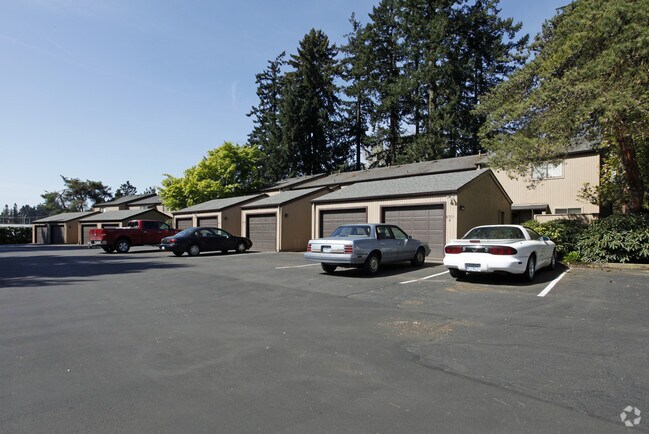

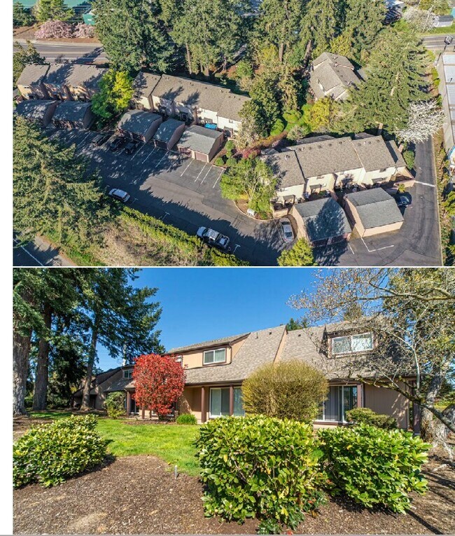

Property Detail
6502 Wheatland Rd N
520392
ACRES 1.73
Multifamilydwelling
Marion
CM
Oregon
B and X Area of moderate flood hazard, usually the area between the limits of the 100-year and 500-year floods.
1.73 AC
2024
Keizer
2025
Portland
002503
Salem, OR
25,296 SF
NEARBY LISTINGS FOR SALE OR LEASE
DEMOGRAPHICS near 6502 Wheatland Rd N
1 mile
3 mile
5 mile
2024 Total Population
14,452
57,488
132,949
2029 Population
14,581
58,451
135,971
Pop Growth 2024-2029
+ 0.89%
+ 1.68%
+ 2.27%
Average Age
42
39
38
2024 Total Households
5,644
20,850
47,597
HH Growth 2024-2029
+ 0.94%
+ 1.69%
+ 2.40%
Median Household Inc
$79,475
$65,274
$60,574
Avg Household Size
2.50
2.70
2.70
2024 Avg HH Vehicles
2.00
2.00
2.00
Median Home Value
$370,551
$343,101
$330,405
Median Year Built
1990
1983
1979
Nearby Places
Map Layers
Map Styles
 Street
 Aerial
Transit
 Traffic
 Biking
Places
Listings with unknown addresses are not visible on the map
- Restaurants
- Banks
- Shops
- Fitness
- Groceries
PUBLIC TRANSPORTATION
COMMUTER RAIL
Salem (Amtrak Cascades - Amtrak, Coast Starlight - Amtrak)
Drive
Walk
Distance
Salem (Amtrak Cascades - Amtrak, Coast Starlight - Amtrak)
15 min
6.3 mi
Freight Ports
Port of Portland
Drive
Walk
Distance
Port of Portland
58 min
44.5 mi
SALE & LEASE HISTORY
LISTING DATE
SALE/LEASE

Aug 13, 2021
For Sale
Nearby Properties
Address
Land Use
TOTAL SIZE
Lot Size
Zoning
Address
Land Use
TOTAL SIZE
Lot Size
Zoning
58,868 SF
38.09 AC
P; RM
Address
Land Use
TOTAL SIZE
Lot Size
Zoning
94,577 SF
10.65 AC
PA
Address
Land Use
TOTAL SIZE
Lot Size
Zoning
236,632 SF
24.45 AC
CO
Address
Land Use
TOTAL SIZE
Lot Size
Zoning
318,068 SF
14.57 AC
RM2
Address
Land Use
TOTAL SIZE
Lot Size
Zoning
1,490 SF
17.41 AC
PA
Address
Land Use
TOTAL SIZE
Lot Size
Zoning
84,940 SF
16.75 AC
IBP
Address
Land Use
TOTAL SIZE
Lot Size
Zoning
68,512 SF
9.09 AC
P
Address
Land Use
TOTAL SIZE
Lot Size
Zoning
29.36 AC
IG; CR
Address
Land Use
TOTAL SIZE
Lot Size
Zoning
161,418 SF
4.48 AC
MU
Address
Land Use
TOTAL SIZE
Lot Size
Zoning
134,440 SF
12.25 AC
IBP
Address
Land Use
TOTAL SIZE
Lot Size
Zoning
42,077 SF
8.54 AC
P
Address
Land Use
TOTAL SIZE
Lot Size
Zoning
150,649 SF
3.67 AC
MU
Address
Land Use
TOTAL SIZE
Lot Size
Zoning
171,349 SF
6.88 AC
RM
Address
Land Use
TOTAL SIZE
Lot Size
Zoning
101,921 SF
3.76 AC
MU
Address
Land Use
TOTAL SIZE
Lot Size
Zoning
74,549 SF
1.62 AC
IC
Address
Land Use
TOTAL SIZE
Lot Size
Zoning
123,752 SF
10.14 AC
IBP
Address
Land Use
TOTAL SIZE
Lot Size
Zoning
49,861 SF
8.60 AC
IC
Address
Land Use
TOTAL SIZE
Lot Size
Zoning
105,537 SF
5.86 AC
RS
Address
Land Use
TOTAL SIZE
Lot Size
Zoning
54,745 SF
5.32 AC
IBP
Address
Land Use
TOTAL SIZE
Lot Size
Zoning
136,937 SF
6.44 AC
RM2
Address
Land Use
TOTAL SIZE
Lot Size
Zoning
102,832 SF
4.93 AC
MU
Address
Land Use
TOTAL SIZE
Lot Size
Zoning
80,628 SF
3.70 AC
RM2
Address
Land Use
TOTAL SIZE
Lot Size
Zoning
Address
Land Use
TOTAL SIZE
Lot Size
Zoning
93,718 SF
7.23 AC
CM
Address
Land Use
TOTAL SIZE
Lot Size
Zoning
120,177 SF
6.60 AC
MU
Address
Land Use
TOTAL SIZE
Lot Size
Zoning
104,415 SF
11.51 AC
IC
Address
Land Use
TOTAL SIZE
Lot Size
Zoning
160,626 SF
12.15 AC
RM2
Address
Land Use
TOTAL SIZE
Lot Size
Zoning
101,224 SF
3.93 AC
RM
Address
Land Use
TOTAL SIZE
Lot Size
Zoning
74,688 SF
3.18 AC
CO
Address
Land Use
TOTAL SIZE
Lot Size
Zoning
79,446 SF
4.86 AC
CM
The World's #1 Commercial Real Estate Marketplace
Connect with us
© 2026 CoStar Group
The information above has been obtained from sources believed reliable. While we do not doubt its accuracy we have not verified it and make no guarantee, warranty or representation about it. It is your responsibility to independently confirm its accuracy and completeness. Any projections, opinions, assumptions, or estimates used are for example only and do not represent the current or future performance of the property. The value of this transaction to you depends on tax and other factors which should be evaluated by your tax, financial, and legal advisors. You and your advisors should conduct a careful, independent investigation of the property to determine to your satisfaction the suitability of the property for your needs.