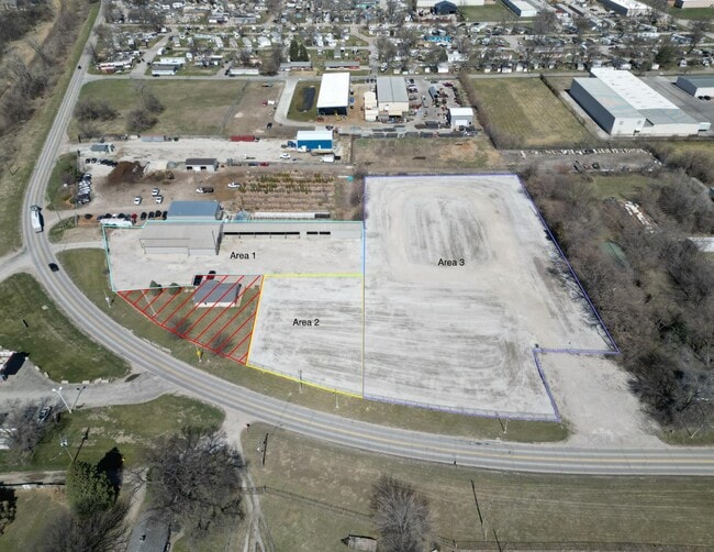
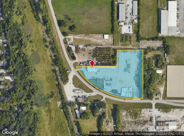
Property Record
6471 John J Pershing Dr, Omaha, NE 68112

Current Lease Availabilities
NEARBY LISTINGS FOR SALE OR LEASE
Property Detail
6471 John J Pershing Dr
Omaha-Council Bluffs, NE-IA
Omaha Acres
1127-0006-19
OMAHA ACRES LOT 27 BLOCK 0 -EX IRREG W 95 FT FOR ST- LOT 25 & IRREG LOT 26 N & E OF PERSHING DR & -EX IRREG S 30 FT- W 1/2 LOT 27
Warehouse
Douglas
X
Nebraska
31055C0229H
27
2024
4.33 AC
2025
Northeast Omaha
000400
Omaha/Council Bluffs
8,429 SF
DEMOGRAPHICS near 6471 John J Pershing Dr
1 Mile
3 Mile
5 Mile
2024 Total Population
8,695
52,586
165,576
2029 Population
8,948
53,776
168,928
Pop Growth 2024-2029
+ 2.91%
+ 2.26%
+ 2.02%
Average Age
36
36
37
2024 Total Households
3,125
19,055
67,022
HH Growth 2024-2029
+ 2.88%
+ 2.26%
+ 2.21%
Median Household Inc
$40,173
$38,416
$47,248
Avg Household Size
2.70
2.60
2.30
2024 Avg HH Vehicles
2.00
2.00
2.00
Median Home Value
$109,244
$113,053
$158,806
Median Year Built
1947
1955
1956
Nearby Places
Map Layers
Map Styles
 Street
 Aerial
- Restaurants
- Banks
- Shops
- Fitness
- Groceries
PUBLIC TRANSPORTATION
COMMUTER RAIL
DRIVE
WALK
Distance
12 min
6.5 mi
DRIVE
WALK
Distance
13 min
6.8 mi
AIRPORT
Eppley Airfield
DRIVE
WALK
Distance
Eppley Airfield
10 min
4.0 mi
Nearby Properties
Address
Land Use
TOTAL SIZE
Lot Size
Zoning
Address
Land Use
TOTAL SIZE
Lot Size
Zoning
39.68 AC
Address
Land Use
TOTAL SIZE
Lot Size
Zoning
18.12 AC
Address
Land Use
TOTAL SIZE
Lot Size
Zoning
540,097 SF
20.98 AC
GI
Address
Land Use
TOTAL SIZE
Lot Size
Zoning
184,154 SF
9.93 AC
Address
Land Use
TOTAL SIZE
Lot Size
Zoning
200,000 SF
11.49 AC
GI
Address
Land Use
TOTAL SIZE
Lot Size
Zoning
164,320 SF
6.88 AC
Address
Land Use
TOTAL SIZE
Lot Size
Zoning
142,451 SF
19.14 AC
Address
Land Use
TOTAL SIZE
Lot Size
Zoning
178,896 SF
16.92 AC
Address
Land Use
TOTAL SIZE
Lot Size
Zoning
113,216 SF
12.93 AC
GI
Address
Land Use
TOTAL SIZE
Lot Size
Zoning
58,945 SF
3.97 AC
Address
Land Use
TOTAL SIZE
Lot Size
Zoning
Address
Land Use
TOTAL SIZE
Lot Size
Zoning
111,770 SF
2.65 AC
Address
Land Use
TOTAL SIZE
Lot Size
Zoning
149,796 SF
13.08 AC
GI
Address
Land Use
TOTAL SIZE
Lot Size
Zoning
97,422 SF
4.06 AC
Address
Land Use
TOTAL SIZE
Lot Size
Zoning
383,283 SF
11.94 AC
GI
Address
Land Use
TOTAL SIZE
Lot Size
Zoning
198,000 SF
14.90 AC
GI
Address
Land Use
TOTAL SIZE
Lot Size
Zoning
1.78 AC
Address
Land Use
TOTAL SIZE
Lot Size
Zoning
246,595 SF
17.53 AC
HI
Address
Land Use
TOTAL SIZE
Lot Size
Zoning
1.90 AC
Address
Land Use
TOTAL SIZE
Lot Size
Zoning
4.76 AC
Address
Land Use
TOTAL SIZE
Lot Size
Zoning
90,000 SF
7.64 AC
GI
Address
Land Use
TOTAL SIZE
Lot Size
Zoning
92,214 SF
4.67 AC
GI
Address
Land Use
TOTAL SIZE
Lot Size
Zoning
88,628 SF
7.80 AC
GI
Address
Land Use
TOTAL SIZE
Lot Size
Zoning
28,084 SF
5.22 AC
Address
Land Use
TOTAL SIZE
Lot Size
Zoning
74,920 SF
4.53 AC
Address
Land Use
TOTAL SIZE
Lot Size
Zoning
9.25 AC
Address
Land Use
TOTAL SIZE
Lot Size
Zoning
62,500 SF
9.84 AC
Address
Land Use
TOTAL SIZE
Lot Size
Zoning
88,125 SF
18.15 AC
GI
Address
Land Use
TOTAL SIZE
Lot Size
Zoning
86,745 SF
7.17 AC
The World's #1 Commercial Real Estate Marketplace
Connect with us
© 2026 CoStar Group
The information above has been obtained from sources believed reliable. While we do not doubt its accuracy we have not verified it and make no guarantee, warranty or representation about it. It is your responsibility to independently confirm its accuracy and completeness. Any projections, opinions, assumptions, or estimates used are for example only and do not represent the current or future performance of the property. The value of this transaction to you depends on tax and other factors which should be evaluated by your tax, financial, and legal advisors. You and your advisors should conduct a careful, independent investigation of the property to determine to your satisfaction the suitability of the property for your needs.