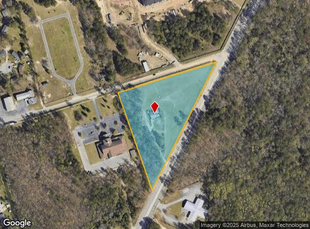
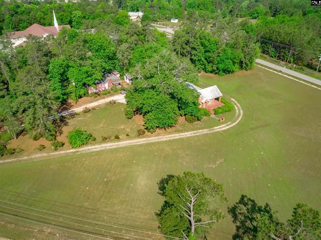
Property Record
6505 N Main St, Columbia, SC 29203

NEARBY LISTINGS FOR SALE OR LEASE
Property Detail
6505 N Main St
Columbia, SC
Estate Of Henry Monteith
11716-01-04
Richland
Sfr
South Carolina
X
5 AC
45079C0234L
North Columbia
1,967 SF
Columbia
DEMOGRAPHICS near 6505 N Main St
1 Mile
3 Mile
5 Mile
2024 Total Population
5,357
44,430
126,211
2029 Population
5,494
45,286
128,516
Pop Growth 2024-2029
+ 2.56%
+ 1.93%
+ 1.83%
Average Age
43
40
38
2024 Total Households
2,276
19,251
55,685
HH Growth 2024-2029
+ 2.59%
+ 1.98%
+ 1.86%
Median Household Inc
$32,479
$36,425
$43,382
Avg Household Size
2.20
2.20
2.10
2024 Avg HH Vehicles
2.00
1.00
2.00
Median Home Value
$97,197
$134,524
$182,394
Median Year Built
1965
1967
1970
Nearby Places
Map Layers
Map Styles
 Street
 Aerial
- Restaurants
- Banks
- Shops
- Fitness
- Groceries
PUBLIC TRANSPORTATION
COMMUTER RAIL
Columbia Amtrak Station (Silver Star - Amtrak)
DRIVE
WALK
Distance
Columbia Amtrak Station (Silver Star - Amtrak)
14 min
7.0 mi
AIRPORT
Columbia Metro
DRIVE
WALK
Distance
Columbia Metro
32 min
18.7 mi
Freight Ports
North Charleston Terminal
DRIVE
WALK
Distance
North Charleston Terminal
132 min
115.0 mi
SALE & LEASE HISTORY
LISTING DATE
SALE/LEASE

May 17, 2022
For Sale
Mar 12, 2024
For Sale
Mar 02, 2020
For Sale
Nearby Properties
Address
Land Use
TOTAL SIZE
Lot Size
Zoning
Address
Land Use
TOTAL SIZE
Lot Size
Zoning
20,434 SF
17.20 AC
C-1
Address
Land Use
TOTAL SIZE
Lot Size
Zoning
354,813 SF
20.66 AC
RM-HD
Address
Land Use
TOTAL SIZE
Lot Size
Zoning
172,390 SF
19.87 AC
GC
Address
Land Use
TOTAL SIZE
Lot Size
Zoning
313,244 SF
12.75 AC
RM-HD
Address
Land Use
TOTAL SIZE
Lot Size
Zoning
260,572 SF
15 AC
GC
Address
Land Use
TOTAL SIZE
Lot Size
Zoning
200,609 SF
17.97 AC
GC
Address
Land Use
TOTAL SIZE
Lot Size
Zoning
239,450 SF
16.85 AC
GC
Address
Land Use
TOTAL SIZE
Lot Size
Zoning
183,237 SF
13.65 AC
GC
Address
Land Use
TOTAL SIZE
Lot Size
Zoning
2,456 SF
5 AC
C-1
Address
Land Use
TOTAL SIZE
Lot Size
Zoning
96,189 SF
2.22 AC
C-1
Address
Land Use
TOTAL SIZE
Lot Size
Zoning
23,379 SF
3.76 AC
M-1
Address
Land Use
TOTAL SIZE
Lot Size
Zoning
223,692 SF
12 AC
GC
Address
Land Use
TOTAL SIZE
Lot Size
Zoning
67,200 SF
1.72 AC
C-1
Address
Land Use
TOTAL SIZE
Lot Size
Zoning
51,353 SF
7.01 AC
GC
Address
Land Use
TOTAL SIZE
Lot Size
Zoning
132,097 SF
10.63 AC
GC
Address
Land Use
TOTAL SIZE
Lot Size
Zoning
1,199.74 AC
OI
Address
Land Use
TOTAL SIZE
Lot Size
Zoning
124,272 SF
7.06 AC
RM-HD
Address
Land Use
TOTAL SIZE
Lot Size
Zoning
84,909 SF
8.26 AC
GC
Address
Land Use
TOTAL SIZE
Lot Size
Zoning
63,842 SF
3.52 AC
C-3
Address
Land Use
TOTAL SIZE
Lot Size
Zoning
4,986 SF
5.74 AC
PUD-C
Address
Land Use
TOTAL SIZE
Lot Size
Zoning
183,184 SF
10.63 AC
GC
Address
Land Use
TOTAL SIZE
Lot Size
Zoning
61,472 SF
6.28 AC
GC
Address
Land Use
TOTAL SIZE
Lot Size
Zoning
134,400 SF
5.85 AC
RG-2
Address
Land Use
TOTAL SIZE
Lot Size
Zoning
199,962 SF
40.13 AC
RG-1
Address
Land Use
TOTAL SIZE
Lot Size
Zoning
96,248 SF
5.97 AC
RM-2
Address
Land Use
TOTAL SIZE
Lot Size
Zoning
8,032 SF
3.20 AC
C-1
Address
Land Use
TOTAL SIZE
Lot Size
Zoning
194,212 SF
15.10 AC
RG-2
Address
Land Use
TOTAL SIZE
Lot Size
Zoning
107,302 SF
16.77 AC
EC
Address
Land Use
TOTAL SIZE
Lot Size
Zoning
193,053 SF
7.43 AC
R-1
Address
Land Use
TOTAL SIZE
Lot Size
Zoning
58,094 SF
4.43 AC
M-1
The World's #1 Commercial Real Estate Marketplace
Connect with us
© 2025 CoStar Group
The information above has been obtained from sources believed reliable. While we do not doubt its accuracy we have not verified it and make no guarantee, warranty or representation about it. It is your responsibility to independently confirm its accuracy and completeness. Any projections, opinions, assumptions, or estimates used are for example only and do not represent the current or future performance of the property. The value of this transaction to you depends on tax and other factors which should be evaluated by your tax, financial, and legal advisors. You and your advisors should conduct a careful, independent investigation of the property to determine to your satisfaction the suitability of the property for your needs.