Property Record
6507 Highway 290 E, Brenham, TX 77833
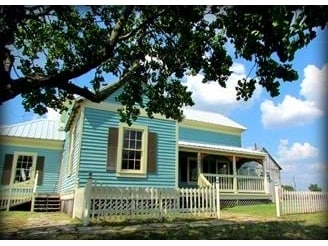

Property Detail
6507 Highway 290 E
0075-000-22000
A0075 LAWERENCE, DAVID, TRACT 220, ACRES 1.42, (0.631 + 0.789 ACRES)
Commercialnec
Washington
B and X Area of moderate flood hazard, usually the area between the limits of the 100-year and 500-year floods.
Texas
2025
1.42 AC
2025
Central Texas Area
170601
Other Market Areas
7,551 SF
Brenham, TX
NEARBY LISTINGS FOR SALE OR LEASE
-
-
View all Brenham listings for sale on LoopNet.com
DEMOGRAPHICS near 6507 Highway 290 E
1 mile
3 mile
5 mile
2025 Total Population
399
1,724
6,768
2030 Population
418
1,809
7,133
Pop Growth 2025-2030
+ 4.76%
+ 4.93%
+ 5.39%
Average Age
46
46
43
2025 Total Households
154
670
2,594
HH Growth 2025-2030
+ 5.84%
+ 5.97%
+ 6.25%
Median Household Inc
$78,693
$81,834
$78,521
Avg Household Size
2.50
2.50
2.40
2025 Avg HH Vehicles
3.00
2.00
2.00
Median Home Value
$356,382
$373,964
$348,272
Median Year Built
2001
2000
1998
Nearby Places
Map Layers
Map Styles
 Street
 Aerial
Layers
 Traffic
 Biking
Places
Listings with unknown addresses are not visible on the map
- Restaurants
- Banks
- Shops
- Fitness
- Groceries
Nearby Properties
Address
Land Use
TOTAL SIZE
Lot Size
Zoning
Address
Land Use
TOTAL SIZE
Lot Size
Zoning
26,964 SF
16.05 AC
Address
Land Use
TOTAL SIZE
Lot Size
Zoning
4,151 SF
373.66 AC
Address
Land Use
TOTAL SIZE
Lot Size
Zoning
Address
Land Use
TOTAL SIZE
Lot Size
Zoning
3,300 SF
225.57 AC
Address
Land Use
TOTAL SIZE
Lot Size
Zoning
1,000 SF
165.61 AC
Address
Land Use
TOTAL SIZE
Lot Size
Zoning
46,596 SF
5.50 AC
Address
Land Use
TOTAL SIZE
Lot Size
Zoning
30,208 SF
25.42 AC
Address
Land Use
TOTAL SIZE
Lot Size
Zoning
132.01 AC
Address
Land Use
TOTAL SIZE
Lot Size
Zoning
Address
Land Use
TOTAL SIZE
Lot Size
Zoning
200.05 AC
Address
Land Use
TOTAL SIZE
Lot Size
Zoning
76,000 SF
97 AC
Address
Land Use
TOTAL SIZE
Lot Size
Zoning
3,613 SF
30 AC
Address
Land Use
TOTAL SIZE
Lot Size
Zoning
5,900 SF
5.66 AC
Address
Land Use
TOTAL SIZE
Lot Size
Zoning
295.31 AC
Address
Land Use
TOTAL SIZE
Lot Size
Zoning
1,339 SF
100.24 AC
Address
Land Use
TOTAL SIZE
Lot Size
Zoning
157.30 AC
Address
Land Use
TOTAL SIZE
Lot Size
Zoning
17,760 SF
10.10 AC
Address
Land Use
TOTAL SIZE
Lot Size
Zoning
8,610 SF
2.83 AC
Address
Land Use
TOTAL SIZE
Lot Size
Zoning
26,492 SF
5.90 AC
Address
Land Use
TOTAL SIZE
Lot Size
Zoning
9,136 SF
20.34 AC
Address
Land Use
TOTAL SIZE
Lot Size
Zoning
295.31 AC
Address
Land Use
TOTAL SIZE
Lot Size
Zoning
87.64 AC
Address
Land Use
TOTAL SIZE
Lot Size
Zoning
75.96 AC
Address
Land Use
TOTAL SIZE
Lot Size
Zoning
4,193 SF
75.28 AC
Address
Land Use
TOTAL SIZE
Lot Size
Zoning
12,665 SF
6.21 AC
Address
Land Use
TOTAL SIZE
Lot Size
Zoning
1,360 SF
162.60 AC
Address
Land Use
TOTAL SIZE
Lot Size
Zoning
1,325 SF
63.23 AC
Address
Land Use
TOTAL SIZE
Lot Size
Zoning
65.09 AC
Address
Land Use
TOTAL SIZE
Lot Size
Zoning
61.33 AC
The World's #1 Commercial Real Estate Marketplace
Connect with us
© 2026 CoStar Group
The information above has been obtained from sources believed reliable. While we do not doubt its accuracy we have not verified it and make no guarantee, warranty or representation about it. It is your responsibility to independently confirm its accuracy and completeness. Any projections, opinions, assumptions, or estimates used are for example only and do not represent the current or future performance of the property. The value of this transaction to you depends on tax and other factors which should be evaluated by your tax, financial, and legal advisors. You and your advisors should conduct a careful, independent investigation of the property to determine to your satisfaction the suitability of the property for your needs.