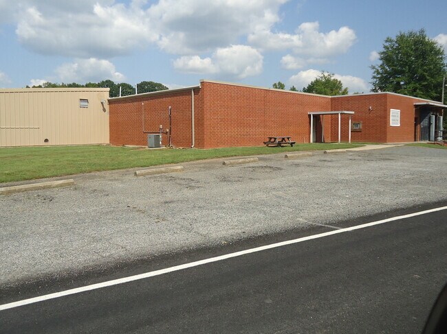
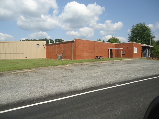
Property Record
651 Garner Rd, Denton, NC 27239

Property Detail
651 Garner Rd
07-035-0-000-0004-0-0-0
L4 BK2582-1900 GARNER RD
Manufacturinglight
DAVIDSON
RA1
North Carolina
B and X Area of moderate flood hazard, usually the area between the limits of the 100-year and 500-year floods.
33.93 AC
2025
South Davidson County
2025
Greensboro/Winston-Salem
062002
Winston-Salem, NC
15,200 SF
NEARBY LISTINGS FOR SALE OR LEASE
-
-
View all Denton listings for sale on LoopNet.com
DEMOGRAPHICS near 651 Garner Rd
1 mile
3 mile
5 mile
2025 Total Population
244
3,642
7,394
2030 Population
257
3,811
7,731
Pop Growth 2025-2030
+ 5.33%
+ 4.64%
+ 4.56%
Average Age
43
43
44
2025 Total Households
102
1,523
3,082
HH Growth 2025-2030
+ 4.90%
+ 4.73%
+ 4.64%
Median Household Inc
$46,833
$47,753
$52,962
Avg Household Size
2.40
2.30
2.30
2025 Avg HH Vehicles
2.00
2.00
2.00
Median Home Value
$199,999
$190,745
$199,458
Median Year Built
1982
1982
1984
Nearby Places
Map Layers
Map Styles
 Street
 Aerial
Transit
 Traffic
 Biking
Places
Listings with unknown addresses are not visible on the map
- Restaurants
- Banks
- Shops
- Fitness
- Groceries
SALE & LEASE HISTORY
LISTING DATE
SALE/LEASE

Oct 12, 2022
For Sale
Nearby Properties
Address
Land Use
TOTAL SIZE
Lot Size
Zoning
Address
Land Use
TOTAL SIZE
Lot Size
Zoning
119,123 SF
57.62 AC
RA1
Address
Land Use
TOTAL SIZE
Lot Size
Zoning
44,898 SF
47.21 AC
RA
Address
Land Use
TOTAL SIZE
Lot Size
Zoning
14,515 SF
17.54 AC
R8
Address
Land Use
TOTAL SIZE
Lot Size
Zoning
900 SF
6.59 AC
RA2
Address
Land Use
TOTAL SIZE
Lot Size
Zoning
15,038 SF
2.27 AC
HB
Address
Land Use
TOTAL SIZE
Lot Size
Zoning
48,158 SF
4.59 AC
LI
Address
Land Use
TOTAL SIZE
Lot Size
Zoning
108,305 SF
37.71 AC
RA
Address
Land Use
TOTAL SIZE
Lot Size
Zoning
78,416 SF
189.02 AC
LI
Address
Land Use
TOTAL SIZE
Lot Size
Zoning
63,750 SF
17.13 AC
LI
Address
Land Use
TOTAL SIZE
Lot Size
Zoning
14,872 SF
2.01 AC
HB
Address
Land Use
TOTAL SIZE
Lot Size
Zoning
43,008 SF
5.91 AC
HB
Address
Land Use
TOTAL SIZE
Lot Size
Zoning
12,715 SF
1.95 AC
HB
Address
Land Use
TOTAL SIZE
Lot Size
Zoning
34,912 SF
7.89 AC
R15
Address
Land Use
TOTAL SIZE
Lot Size
Zoning
5,340 SF
1.27 AC
NB
Address
Land Use
TOTAL SIZE
Lot Size
Zoning
139,329 SF
12.68 AC
LI
Address
Land Use
TOTAL SIZE
Lot Size
Zoning
9,265 SF
1.28 AC
HB
Address
Land Use
TOTAL SIZE
Lot Size
Zoning
16,000 SF
7.14 AC
RA2
Address
Land Use
TOTAL SIZE
Lot Size
Zoning
7,408 SF
0.83 AC
HB
Address
Land Use
TOTAL SIZE
Lot Size
Zoning
19,876 SF
5.36 AC
LI
Address
Land Use
TOTAL SIZE
Lot Size
Zoning
16,287 SF
16.97 AC
RA1
Address
Land Use
TOTAL SIZE
Lot Size
Zoning
7,972 SF
3.70 AC
R8
Address
Land Use
TOTAL SIZE
Lot Size
Zoning
7,200 SF
7.02 AC
LI
Address
Land Use
TOTAL SIZE
Lot Size
Zoning
4,500 SF
1.04 AC
R15
Address
Land Use
TOTAL SIZE
Lot Size
Zoning
7,674 SF
0.87 AC
HB
Address
Land Use
TOTAL SIZE
Lot Size
Zoning
23,800 SF
5.02 AC
LI
Address
Land Use
TOTAL SIZE
Lot Size
Zoning
5,428 SF
0.89 AC
R8
Address
Land Use
TOTAL SIZE
Lot Size
Zoning
4,576 SF
0.67 AC
HB
Address
Land Use
TOTAL SIZE
Lot Size
Zoning
17.02 AC
RA
Address
Land Use
TOTAL SIZE
Lot Size
Zoning
2,256 SF
3.03 AC
R8
Address
Land Use
TOTAL SIZE
Lot Size
Zoning
11,180 SF
6.33 AC
LI
The World's #1 Commercial Real Estate Marketplace
Connect with us
© 2026 CoStar Group
The information above has been obtained from sources believed reliable. While we do not doubt its accuracy we have not verified it and make no guarantee, warranty or representation about it. It is your responsibility to independently confirm its accuracy and completeness. Any projections, opinions, assumptions, or estimates used are for example only and do not represent the current or future performance of the property. The value of this transaction to you depends on tax and other factors which should be evaluated by your tax, financial, and legal advisors. You and your advisors should conduct a careful, independent investigation of the property to determine to your satisfaction the suitability of the property for your needs.