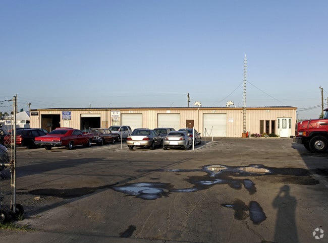
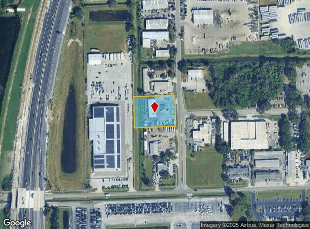
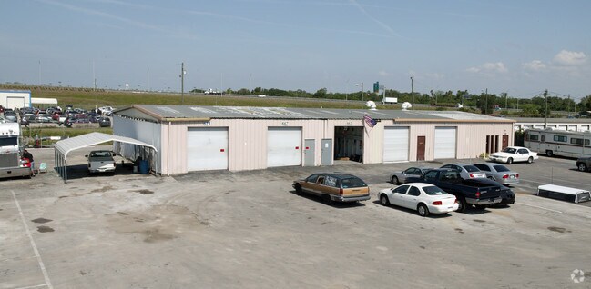
Property Record
651 L F Roper Pky, Ocoee, FL 34761
NEARBY LISTINGS FOR SALE OR LEASE
Property Detail
651 L F Roper Pky
Orlando-Kissimmee-Sanford, FL
West Orange Indus Pk Ut 2
19-2228-9153-00-300
WEST ORANGE IND PARK UNIT 2 5/84 LOT A-3
Autorepair
Orange
X
Florida
12095C0220H
a-3
2024
1.34 AC
2025
NW Orange County
018100
Orlando
6,158 SF
DEMOGRAPHICS near 651 L F Roper Pky
1 Mile
3 Mile
5 Mile
2024 Total Population
2,757
66,775
151,469
2029 Population
2,856
68,731
156,017
Pop Growth 2024-2029
+ 3.59%
+ 2.93%
+ 3.00%
Average Age
40
40
39
2024 Total Households
871
23,278
51,600
HH Growth 2024-2029
+ 3.67%
+ 2.93%
+ 3.02%
Median Household Inc
$37,000
$73,527
$78,824
Avg Household Size
2.80
2.80
2.90
2024 Avg HH Vehicles
2.00
2.00
2.00
Median Home Value
$323,092
$334,887
$344,804
Median Year Built
1981
1995
1996
Nearby Places
Map Layers
Map Styles
 Street
 Aerial
- Restaurants
- Banks
- Shops
- Fitness
- Groceries
PUBLIC TRANSPORTATION
AIRPORT
Orlando International
DRIVE
WALK
Distance
Orlando International
34 min
23.5 mi
Orlando Sanford International
DRIVE
WALK
Distance
Orlando Sanford International
52 min
39.0 mi
Nearby Properties
Address
Land Use
TOTAL SIZE
Lot Size
Zoning
Address
Land Use
TOTAL SIZE
Lot Size
Zoning
840,260 SF
65.85 AC
C-2
Address
Land Use
TOTAL SIZE
Lot Size
Zoning
632,562 SF
55 AC
PCD
Address
Land Use
TOTAL SIZE
Lot Size
Zoning
481,795 SF
16.56 AC
I-1
Address
Land Use
TOTAL SIZE
Lot Size
Zoning
669,041 SF
43.79 AC
I-1
Address
Land Use
TOTAL SIZE
Lot Size
Zoning
782,050 SF
44.78 AC
A-1
Address
Land Use
TOTAL SIZE
Lot Size
Zoning
668,180 SF
52.21 AC
PUD-PU
Address
Land Use
TOTAL SIZE
Lot Size
Zoning
693,608 SF
24.41 AC
PUD-HD
Address
Land Use
TOTAL SIZE
Lot Size
Zoning
368,910 SF
14.02 AC
CAPUD
Address
Land Use
TOTAL SIZE
Lot Size
Zoning
342,875 SF
11.35 AC
PUD-COMM
Address
Land Use
TOTAL SIZE
Lot Size
Zoning
446,425 SF
25.15 AC
PUD-IND
Address
Land Use
TOTAL SIZE
Lot Size
Zoning
347,605 SF
9.10 AC
C-2
Address
Land Use
TOTAL SIZE
Lot Size
Zoning
347,506 SF
3.55 AC
PUD-MD
Address
Land Use
TOTAL SIZE
Lot Size
Zoning
167,285 SF
164.77 AC
C-3
Address
Land Use
TOTAL SIZE
Lot Size
Zoning
314,643 SF
38.04 AC
PUD
Address
Land Use
TOTAL SIZE
Lot Size
Zoning
263,067 SF
41.46 AC
P-D
Address
Land Use
TOTAL SIZE
Lot Size
Zoning
265,223 SF
1.89 AC
R-3
Address
Land Use
TOTAL SIZE
Lot Size
Zoning
209,545 SF
20.04 AC
R-3
Address
Land Use
TOTAL SIZE
Lot Size
Zoning
203,729 SF
11.46 AC
PUD-HD
Address
Land Use
TOTAL SIZE
Lot Size
Zoning
196,924 SF
2.53 AC
P-S
Address
Land Use
TOTAL SIZE
Lot Size
Zoning
221,959 SF
10.82 AC
P-D
Address
Land Use
TOTAL SIZE
Lot Size
Zoning
493,556 SF
28.89 AC
I-2
Address
Land Use
TOTAL SIZE
Lot Size
Zoning
364,641 SF
29.26 AC
R-3
Address
Land Use
TOTAL SIZE
Lot Size
Zoning
80,744 SF
9.40 AC
R-2
Address
Land Use
TOTAL SIZE
Lot Size
Zoning
179,371 SF
21.52 AC
A-1
Address
Land Use
TOTAL SIZE
Lot Size
Zoning
261,608 SF
21.73 AC
C-2
Address
Land Use
TOTAL SIZE
Lot Size
Zoning
170,960 SF
22.17 AC
R-2
Address
Land Use
TOTAL SIZE
Lot Size
Zoning
169,734 SF
2.46 AC
R-3
Address
Land Use
TOTAL SIZE
Lot Size
Zoning
151,838 SF
7.15 AC
R-1
Address
Land Use
TOTAL SIZE
Lot Size
Zoning
111,130 SF
15 AC
P-D
Address
Land Use
TOTAL SIZE
Lot Size
Zoning
94,877 SF
7.01 AC
PCD
The World's #1 Commercial Real Estate Marketplace
Connect with us
© 2025 CoStar Group
The information above has been obtained from sources believed reliable. While we do not doubt its accuracy we have not verified it and make no guarantee, warranty or representation about it. It is your responsibility to independently confirm its accuracy and completeness. Any projections, opinions, assumptions, or estimates used are for example only and do not represent the current or future performance of the property. The value of this transaction to you depends on tax and other factors which should be evaluated by your tax, financial, and legal advisors. You and your advisors should conduct a careful, independent investigation of the property to determine to your satisfaction the suitability of the property for your needs.