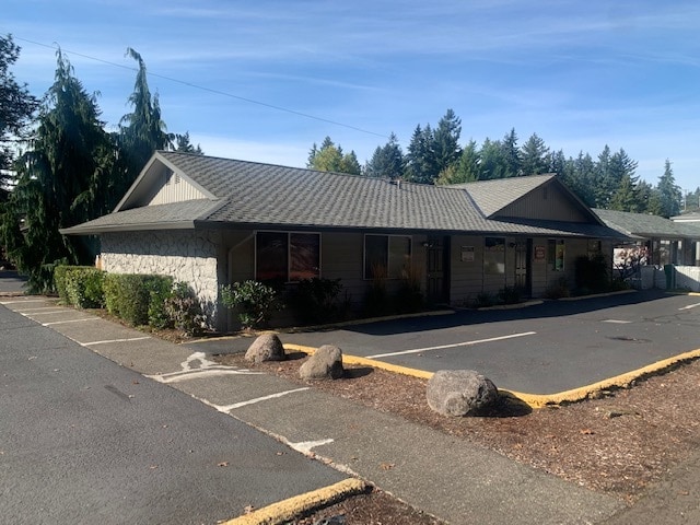
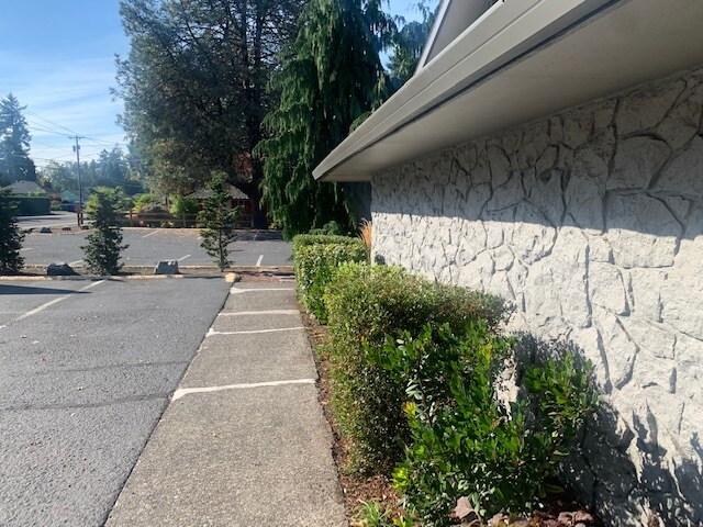
Property Record
6537 Se King Rd, Portland, OR 97222

NEARBY LISTINGS FOR SALE OR LEASE
Property Detail
6537 Se King Rd
Portland-Vancouver-Hillsboro, OR-WA
Haney View
00063059
652 HANEY VIEW PT LTS 1&23 BLK 1
Commercialbuilding
Clackamas
X
Oregon
41051C0400H
1,23
0
0.18 AC
2025
Clackamas/Milwaukie
021601
Portland
DEMOGRAPHICS near 6537 Se King Rd
1 Mile
3 Mile
5 Mile
2024 Total Population
15,532
133,029
349,809
2029 Population
15,846
133,455
349,340
Pop Growth 2024-2029
+ 2.02%
+ 0.32%
(0.13%)
Average Age
41
41
41
2024 Total Households
6,137
52,968
138,975
HH Growth 2024-2029
+ 1.99%
+ 0.27%
(0.31%)
Median Household Inc
$75,642
$81,016
$86,424
Avg Household Size
2.40
2.40
2.40
2024 Avg HH Vehicles
2.00
2.00
2.00
Median Home Value
$396,451
$463,889
$494,071
Median Year Built
1969
1970
1972
Nearby Places
Map Layers
Map Styles
 Street
 Aerial
- Restaurants
- Banks
- Shops
- Fitness
- Groceries
PUBLIC TRANSPORTATION
COMMUTER RAIL
DRIVE
WALK
Distance
13 min
7.2 mi
DRIVE
WALK
Distance
20 min
9.0 mi
AIRPORT
Portland International
DRIVE
WALK
Distance
Portland International
22 min
13.2 mi
Freight Ports
Port of Portland
DRIVE
WALK
Distance
Port of Portland
23 min
11.6 mi
SALE & LEASE HISTORY
LISTING DATE
SALE/LEASE

Oct 24, 2021
For Sale
Nearby Properties
Address
Land Use
TOTAL SIZE
Lot Size
Zoning
Address
Land Use
TOTAL SIZE
Lot Size
Zoning
22 AC
PMU1
Address
Land Use
TOTAL SIZE
Lot Size
Zoning
822,867 SF
103.39 AC
CI1
Address
Land Use
TOTAL SIZE
Lot Size
Zoning
28.83 AC
RCO
Address
Land Use
TOTAL SIZE
Lot Size
Zoning
Address
Land Use
TOTAL SIZE
Lot Size
Zoning
Address
Land Use
TOTAL SIZE
Lot Size
Zoning
Address
Land Use
TOTAL SIZE
Lot Size
Zoning
828 SF
23.69 AC
MR2
Address
Land Use
TOTAL SIZE
Lot Size
Zoning
6.48 AC
R-3
Address
Land Use
TOTAL SIZE
Lot Size
Zoning
15.05 AC
CC
Address
Land Use
TOTAL SIZE
Lot Size
Zoning
3,550 SF
3.99 AC
DMU
Address
Land Use
TOTAL SIZE
Lot Size
Zoning
2,183 SF
6 AC
RCHDR
Address
Land Use
TOTAL SIZE
Lot Size
Zoning
2,108 SF
12.08 AC
HDR
Address
Land Use
TOTAL SIZE
Lot Size
Zoning
11 AC
RCHDR
Address
Land Use
TOTAL SIZE
Lot Size
Zoning
Address
Land Use
TOTAL SIZE
Lot Size
Zoning
Address
Land Use
TOTAL SIZE
Lot Size
Zoning
24 AC
LI
Address
Land Use
TOTAL SIZE
Lot Size
Zoning
57,300 SF
4.38 AC
R5
Address
Land Use
TOTAL SIZE
Lot Size
Zoning
20 AC
RTL
Address
Land Use
TOTAL SIZE
Lot Size
Zoning
14.06 AC
C3
Address
Land Use
TOTAL SIZE
Lot Size
Zoning
Address
Land Use
TOTAL SIZE
Lot Size
Zoning
500 SF
9 AC
RCHDR
Address
Land Use
TOTAL SIZE
Lot Size
Zoning
0.26 AC
C3
Address
Land Use
TOTAL SIZE
Lot Size
Zoning
64,658 SF
7.79 AC
R5
Address
Land Use
TOTAL SIZE
Lot Size
Zoning
11.35 AC
C3
Address
Land Use
TOTAL SIZE
Lot Size
Zoning
1,032 SF
5.50 AC
MR2
Address
Land Use
TOTAL SIZE
Lot Size
Zoning
62,048 SF
8.58 AC
R20
Address
Land Use
TOTAL SIZE
Lot Size
Zoning
5.24 AC
SCMU
Address
Land Use
TOTAL SIZE
Lot Size
Zoning
143,116 SF
0.92 AC
CM2
Address
Land Use
TOTAL SIZE
Lot Size
Zoning
3.10 AC
RCO
Address
Land Use
TOTAL SIZE
Lot Size
Zoning
11.10 AC
HDR
The World's #1 Commercial Real Estate Marketplace
Connect with us
© 2025 CoStar Group
The information above has been obtained from sources believed reliable. While we do not doubt its accuracy we have not verified it and make no guarantee, warranty or representation about it. It is your responsibility to independently confirm its accuracy and completeness. Any projections, opinions, assumptions, or estimates used are for example only and do not represent the current or future performance of the property. The value of this transaction to you depends on tax and other factors which should be evaluated by your tax, financial, and legal advisors. You and your advisors should conduct a careful, independent investigation of the property to determine to your satisfaction the suitability of the property for your needs.