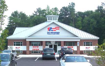
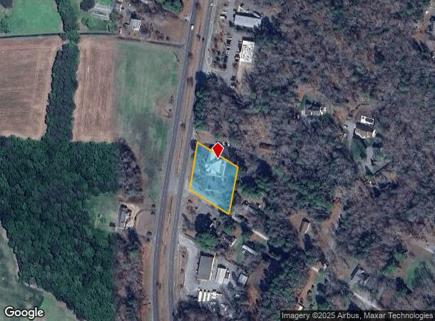
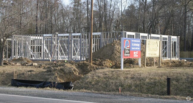
Property Record
6511 George Wash Memorial Hwy, , VA
NEARBY LISTINGS FOR SALE OR LEASE
Property Detail
6511 George Wash Memorial Hwy
20784
Plat: Pb22 661
Financialbuilding
SHORT LANE
X
Gloucester
51073C0120F
Virginia
2025
0.92 AC
2025
Gloucester
1002034018
Hampton Roads
3,721 SF
Virginia Beach-Norfolk-Newport News, VA-NC
DEMOGRAPHICS near 6511 George Wash Memorial Hwy
1 Mile
3 Mile
5 Mile
2024 Total Population
1,013
7,404
16,970
2029 Population
1,097
7,765
17,714
Pop Growth 2024-2029
+ 8.29%
+ 4.88%
+ 4.38%
Average Age
43
44
43
2024 Total Households
391
2,876
6,574
HH Growth 2024-2029
+ 8.18%
+ 4.83%
+ 4.32%
Median Household Inc
$76,982
$76,739
$81,125
Avg Household Size
2.40
2.40
2.50
2024 Avg HH Vehicles
2.00
2.00
2.00
Median Home Value
$295,789
$279,659
$278,978
Median Year Built
1999
1989
1987
Nearby Places
Map Layers
Map Styles
 Street
 Aerial
- Restaurants
- Banks
- Shops
- Fitness
- Groceries
PUBLIC TRANSPORTATION
AIRPORT
Newport News/Williamsburg International
DRIVE
WALK
Distance
Newport News/Williamsburg International
32 min
20.3 mi
Freight Ports
Virginia Port Authority - Newport News
DRIVE
WALK
Distance
Virginia Port Authority - Newport News
50 min
33.6 mi
Nearby Properties
Address
Land Use
TOTAL SIZE
Lot Size
Zoning
Address
Land Use
TOTAL SIZE
Lot Size
Zoning
70,334 SF
18.98 AC
B-1
Address
Land Use
TOTAL SIZE
Lot Size
Zoning
49,507 SF
56.81 AC
SC-1
Address
Land Use
TOTAL SIZE
Lot Size
Zoning
35,711 SF
136.70 AC
SC-1
Address
Land Use
TOTAL SIZE
Lot Size
Zoning
223,593 SF
21.45 AC
B-1
Address
Land Use
TOTAL SIZE
Lot Size
Zoning
16,980 SF
19.50 AC
B-2
Address
Land Use
TOTAL SIZE
Lot Size
Zoning
9.77 AC
B-1
Address
Land Use
TOTAL SIZE
Lot Size
Zoning
16,889 SF
7.52 AC
SF-1
Address
Land Use
TOTAL SIZE
Lot Size
Zoning
87,604 SF
16.14 AC
B-1
Address
Land Use
TOTAL SIZE
Lot Size
Zoning
36,824 SF
3.73 AC
B-1
Address
Land Use
TOTAL SIZE
Lot Size
Zoning
104,911 SF
21.38 AC
B-1
Address
Land Use
TOTAL SIZE
Lot Size
Zoning
59,580 SF
41.98 AC
SC-1
Address
Land Use
TOTAL SIZE
Lot Size
Zoning
37,200 SF
6.37 AC
B-2
Address
Land Use
TOTAL SIZE
Lot Size
Zoning
110,191 SF
23.37 AC
B-1
Address
Land Use
TOTAL SIZE
Lot Size
Zoning
78,198 SF
11.16 AC
B-1
Address
Land Use
TOTAL SIZE
Lot Size
Zoning
175,323 SF
16.18 AC
I-1
Address
Land Use
TOTAL SIZE
Lot Size
Zoning
41,528 SF
1.61 AC
B-1
Address
Land Use
TOTAL SIZE
Lot Size
Zoning
49,849 SF
4.24 AC
B-1
Address
Land Use
TOTAL SIZE
Lot Size
Zoning
16,048 SF
9.90 AC
B-1
Address
Land Use
TOTAL SIZE
Lot Size
Zoning
70,334 SF
18.98 AC
B-1
Address
Land Use
TOTAL SIZE
Lot Size
Zoning
5,850 SF
5.28 AC
B-1
Address
Land Use
TOTAL SIZE
Lot Size
Zoning
38,538 SF
6.09 AC
SF-1
Address
Land Use
TOTAL SIZE
Lot Size
Zoning
72,837 SF
6.40 AC
B-2
Address
Land Use
TOTAL SIZE
Lot Size
Zoning
1.76 AC
MF-1
Address
Land Use
TOTAL SIZE
Lot Size
Zoning
1.52 AC
MF-1
Address
Land Use
TOTAL SIZE
Lot Size
Zoning
38,928 SF
5.60 AC
B-1
Address
Land Use
TOTAL SIZE
Lot Size
Zoning
12,707 SF
3.22 AC
B-2
Address
Land Use
TOTAL SIZE
Lot Size
Zoning
2.16 AC
MF-1
Address
Land Use
TOTAL SIZE
Lot Size
Zoning
6.56 AC
B-1
Address
Land Use
TOTAL SIZE
Lot Size
Zoning
11,174 SF
7 AC
B-1
Address
Land Use
TOTAL SIZE
Lot Size
Zoning
651.87 AC
PUD1
The World's #1 Commercial Real Estate Marketplace
Connect with us
© 2026 CoStar Group
The information above has been obtained from sources believed reliable. While we do not doubt its accuracy we have not verified it and make no guarantee, warranty or representation about it. It is your responsibility to independently confirm its accuracy and completeness. Any projections, opinions, assumptions, or estimates used are for example only and do not represent the current or future performance of the property. The value of this transaction to you depends on tax and other factors which should be evaluated by your tax, financial, and legal advisors. You and your advisors should conduct a careful, independent investigation of the property to determine to your satisfaction the suitability of the property for your needs.