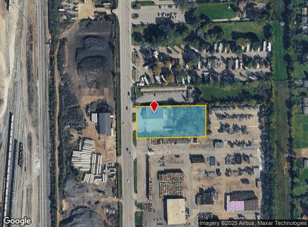
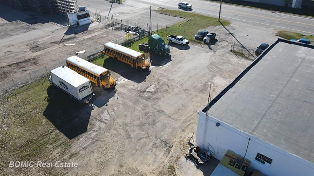
Property Record
6512 N Dort Hwy, Flint, MI 48505
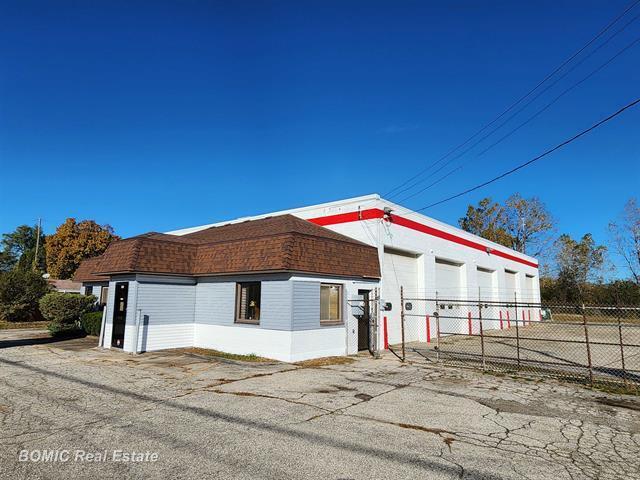
This Property Is For Sale
NEARBY LISTINGS FOR SALE OR LEASE
Property Detail
6512 N Dort Hwy
47-29-102-043
UNPLATTED. PART OF W 1/2 OF NW 1/4 OF SEC 29, T8N, R7E. BEG AT A PT ON E LINE OF DORT HWY N 0 DEG 56 MIN E, 1081.65 FT FROM
Commercialnec
Genesee
X
Michigan
26049C0183D
1.62 AC
2024
Flint
2025
Detroit
001800
Flint, MI
7,640 SF
DEMOGRAPHICS near 6512 N Dort Hwy
1 Mile
3 Mile
5 Mile
2024 Total Population
4,365
52,716
122,525
2029 Population
4,476
54,248
124,555
Pop Growth 2024-2029
+ 2.54%
+ 2.91%
+ 1.66%
Average Age
33
39
40
2024 Total Households
1,702
21,559
50,495
HH Growth 2024-2029
+ 2.53%
+ 2.93%
+ 1.66%
Median Household Inc
$23,287
$32,544
$37,275
Avg Household Size
2.50
2.30
2.30
2024 Avg HH Vehicles
1.00
1.00
1.00
Median Home Value
$59,798
$62,922
$74,089
Median Year Built
1960
1960
1959
Nearby Places
Map Layers
Map Styles
 Street
 Aerial
- Restaurants
- Banks
- Shops
- Fitness
- Groceries
PUBLIC TRANSPORTATION
COMMUTER RAIL
Flint Amtrak Station (Blue Water - Amtrak)
DRIVE
WALK
Distance
Flint Amtrak Station (Blue Water - Amtrak)
8 min
4.7 mi
AIRPORT
Bishop International
DRIVE
WALK
Distance
Bishop International
25 min
12.7 mi
Freight Ports
Port of Toledo
DRIVE
WALK
Distance
Port of Toledo
141 min
118.6 mi
Nearby Properties
Address
Land Use
TOTAL SIZE
Lot Size
Zoning
Address
Land Use
TOTAL SIZE
Lot Size
Zoning
46,808 SF
32.06 AC
I-2 HVY IN
Address
Land Use
TOTAL SIZE
Lot Size
Zoning
329,849 SF
21.20 AC
CE
Address
Land Use
TOTAL SIZE
Lot Size
Zoning
156,250 SF
Address
Land Use
TOTAL SIZE
Lot Size
Zoning
114,888 SF
11.86 AC
I-2 HVY IN
Address
Land Use
TOTAL SIZE
Lot Size
Zoning
182,408 SF
Address
Land Use
TOTAL SIZE
Lot Size
Zoning
Address
Land Use
TOTAL SIZE
Lot Size
Zoning
Address
Land Use
TOTAL SIZE
Lot Size
Zoning
173,312 SF
23.49 AC
CE
Address
Land Use
TOTAL SIZE
Lot Size
Zoning
101,744 SF
4.90 AC
TN-2
Address
Land Use
TOTAL SIZE
Lot Size
Zoning
726 SF
10.40 AC
R-4 MANUF
Address
Land Use
TOTAL SIZE
Lot Size
Zoning
43,751 SF
3.14 AC
TN-2
Address
Land Use
TOTAL SIZE
Lot Size
Zoning
52,434 SF
4.09 AC
CE
Address
Land Use
TOTAL SIZE
Lot Size
Zoning
114,221 SF
6.16 AC
CC
Address
Land Use
TOTAL SIZE
Lot Size
Zoning
9,934 SF
9.70 AC
I-2 HVY IN
Address
Land Use
TOTAL SIZE
Lot Size
Zoning
76,051 SF
8.31 AC
C-2 HWY CO
Address
Land Use
TOTAL SIZE
Lot Size
Zoning
39,274 SF
20.76 AC
CE
Address
Land Use
TOTAL SIZE
Lot Size
Zoning
110,985 SF
11.25 AC
Address
Land Use
TOTAL SIZE
Lot Size
Zoning
80,999 SF
23.82 AC
CE
Address
Land Use
TOTAL SIZE
Lot Size
Zoning
108,740 SF
5.56 AC
CE
Address
Land Use
TOTAL SIZE
Lot Size
Zoning
123,690 SF
9.73 AC
PC
Address
Land Use
TOTAL SIZE
Lot Size
Zoning
3,434 SF
5.63 AC
I-1 LHGT I
Address
Land Use
TOTAL SIZE
Lot Size
Zoning
10.15 AC
Address
Land Use
TOTAL SIZE
Lot Size
Zoning
49,798 SF
4.22 AC
CC
Address
Land Use
TOTAL SIZE
Lot Size
Zoning
20.06 AC
Address
Land Use
TOTAL SIZE
Lot Size
Zoning
86,786 SF
9.41 AC
CE
Address
Land Use
TOTAL SIZE
Lot Size
Zoning
50,760 SF
5.99 AC
GI-1
Address
Land Use
TOTAL SIZE
Lot Size
Zoning
163,940 SF
14.53 AC
MR-1
Address
Land Use
TOTAL SIZE
Lot Size
Zoning
25,800 SF
4.94 AC
I-2 HVY IN
Address
Land Use
TOTAL SIZE
Lot Size
Zoning
3.11 AC
Address
Land Use
TOTAL SIZE
Lot Size
Zoning
17,570 SF
15.65 AC
CE
The World's #1 Commercial Real Estate Marketplace
Connect with us
© 2025 CoStar Group
The information above has been obtained from sources believed reliable. While we do not doubt its accuracy we have not verified it and make no guarantee, warranty or representation about it. It is your responsibility to independently confirm its accuracy and completeness. Any projections, opinions, assumptions, or estimates used are for example only and do not represent the current or future performance of the property. The value of this transaction to you depends on tax and other factors which should be evaluated by your tax, financial, and legal advisors. You and your advisors should conduct a careful, independent investigation of the property to determine to your satisfaction the suitability of the property for your needs.