Property Record
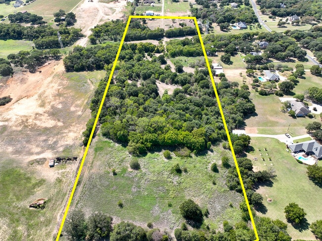
6515 Bennett Lawson Rd, Mansfield, TX 76063


Property Detail
6515 Bennett Lawson Rd
Dallas-Fort Worth-Arlington, TX
GIBSON, JAMES SURVEY ABSTRACT 620 TRACT 1A & 2A2
03910156
TARRANT
Timberlandforesttreesagricultural
Texas
A Areas with a 1% annual chance of flooding and a 26% chance of flooding over the life of a 30-year mortgage.
19.88 AC
2025
Southeast Ft Worth
2025
Dallas/Ft Worth
111318
NEARBY LISTINGS FOR SALE OR LEASE
DEMOGRAPHICS near 6515 Bennett Lawson Rd
1 mile
3 mile
5 mile
2025 Total Population
872
22,473
96,528
2030 Population
934
23,976
102,596
Pop Growth 2025-2030
+ 7.11%
+ 6.69%
+ 6.29%
Average Age
42
39
39
2025 Total Households
308
7,604
33,187
HH Growth 2025-2030
+ 7.14%
+ 6.88%
+ 6.44%
Median Household Inc
$96,621
$98,441
$102,865
Avg Household Size
2.80
2.90
2.90
2025 Avg HH Vehicles
2.00
2.00
2.00
Median Home Value
$389,795
$424,001
$380,560
Median Year Built
1989
2002
1997
Nearby Places
Map Layers
Map Styles
 Street
 Aerial
Layers
 Traffic
 Biking
Places
Listings with unknown addresses are not visible on the map
- Restaurants
- Banks
- Shops
- Fitness
- Groceries
PUBLIC TRANSPORTATION
AIRPORT
Dallas-Fort Worth International
Drive
Walk
Distance
Dallas-Fort Worth International
48 min
31.1 mi
Dallas Love Field
Drive
Walk
Distance
Dallas Love Field
58 min
39.6 mi
SALE & LEASE HISTORY
LISTING DATE
SALE/LEASE

Oct 03, 2022
For Sale
Nearby Properties
Address
Land Use
TOTAL SIZE
Lot Size
Zoning
Address
Land Use
TOTAL SIZE
Lot Size
Zoning
160,000 SF
26.90 AC
Address
Land Use
TOTAL SIZE
Lot Size
Zoning
298,988 SF
7.16 AC
Address
Land Use
TOTAL SIZE
Lot Size
Zoning
199,066 SF
66.49 AC
Address
Land Use
TOTAL SIZE
Lot Size
Zoning
170,082 SF
36.49 AC
Address
Land Use
TOTAL SIZE
Lot Size
Zoning
231,551 SF
25.69 AC
Address
Land Use
TOTAL SIZE
Lot Size
Zoning
234,580 SF
65.82 AC
Address
Land Use
TOTAL SIZE
Lot Size
Zoning
229,168 SF
6.13 AC
Address
Land Use
TOTAL SIZE
Lot Size
Zoning
149,494 SF
3.73 AC
Address
Land Use
TOTAL SIZE
Lot Size
Zoning
79,070 SF
11.98 AC
Address
Land Use
TOTAL SIZE
Lot Size
Zoning
44,669 SF
9.05 AC
Address
Land Use
TOTAL SIZE
Lot Size
Zoning
22.84 AC
Address
Land Use
TOTAL SIZE
Lot Size
Zoning
41,960 SF
13.70 AC
Address
Land Use
TOTAL SIZE
Lot Size
Zoning
143,210 SF
9.78 AC
Address
Land Use
TOTAL SIZE
Lot Size
Zoning
143,104 SF
7.75 AC
Address
Land Use
TOTAL SIZE
Lot Size
Zoning
73,323 SF
11.87 AC
Address
Land Use
TOTAL SIZE
Lot Size
Zoning
1,008 SF
20.48 AC
Address
Land Use
TOTAL SIZE
Lot Size
Zoning
112,110 SF
14.64 AC
Address
Land Use
TOTAL SIZE
Lot Size
Zoning
38,400 SF
43.84 AC
Address
Land Use
TOTAL SIZE
Lot Size
Zoning
2,088 SF
19.19 AC
Address
Land Use
TOTAL SIZE
Lot Size
Zoning
50,000 SF
17.96 AC
Address
Land Use
TOTAL SIZE
Lot Size
Zoning
107,055 SF
9.92 AC
Address
Land Use
TOTAL SIZE
Lot Size
Zoning
191,419 SF
19.10 AC
Address
Land Use
TOTAL SIZE
Lot Size
Zoning
11,388 SF
232.89 AC
Address
Land Use
TOTAL SIZE
Lot Size
Zoning
37,133 SF
19.10 AC
Address
Land Use
TOTAL SIZE
Lot Size
Zoning
80,424 SF
4.20 AC
Address
Land Use
TOTAL SIZE
Lot Size
Zoning
77,845 SF
13.52 AC
Address
Land Use
TOTAL SIZE
Lot Size
Zoning
3,852 SF
5.75 AC
Address
Land Use
TOTAL SIZE
Lot Size
Zoning
78,306 SF
5.13 AC
Address
Land Use
TOTAL SIZE
Lot Size
Zoning
78,000 SF
9.06 AC
Address
Land Use
TOTAL SIZE
Lot Size
Zoning
37,500 SF
1 AC
The World's #1 Commercial Real Estate Marketplace
Connect with us
© 2026 CoStar Group
The information above has been obtained from sources believed reliable. While we do not doubt its accuracy we have not verified it and make no guarantee, warranty or representation about it. It is your responsibility to independently confirm its accuracy and completeness. Any projections, opinions, assumptions, or estimates used are for example only and do not represent the current or future performance of the property. The value of this transaction to you depends on tax and other factors which should be evaluated by your tax, financial, and legal advisors. You and your advisors should conduct a careful, independent investigation of the property to determine to your satisfaction the suitability of the property for your needs.