Property Record
6515 S High St, Lockbourne, OH 43137
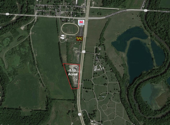
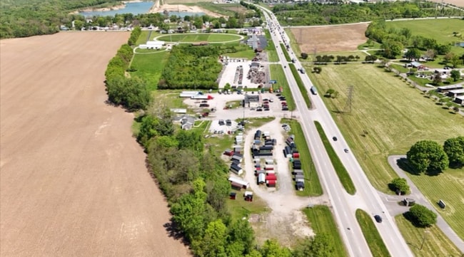
This Property Is For Sale
NEARBY LISTINGS FOR SALE OR LEASE
Property Detail
6515 S High St
Columbus, OH
Congress Lands
150-000177
6555 S HIGH ST 2 ACRES R22 T3-4 S33-4 LOT 1
Restaurantbuilding
Franklin
X
Ohio
39129C0050J
1
2024
2 AC
2024
Southwest
009590
Columbus
3,652 SF
DEMOGRAPHICS near 6515 S High St
1 Mile
3 Mile
5 Mile
2024 Total Population
306
13,330
50,412
2029 Population
302
13,691
51,154
Pop Growth 2024-2029
(1.31%)
+ 2.71%
+ 1.47%
Average Age
38
39
40
2024 Total Households
109
4,772
18,851
HH Growth 2024-2029
(1.83%)
+ 2.70%
+ 1.39%
Median Household Inc
$73,928
$91,851
$79,469
Avg Household Size
2.80
2.80
2.60
2024 Avg HH Vehicles
2.00
2.00
2.00
Median Home Value
$286,841
$250,653
$234,882
Median Year Built
1983
1993
1993
Nearby Places
Map Layers
Map Styles
 Street
 Aerial
- Restaurants
- Banks
- Shops
- Fitness
- Groceries
PUBLIC TRANSPORTATION
AIRPORT
Rickenbacker International
DRIVE
WALK
Distance
Rickenbacker International
10 min
5.0 mi
John Glenn Columbus International
DRIVE
WALK
Distance
John Glenn Columbus International
28 min
18.8 mi
Freight Ports
Port of Toledo
DRIVE
WALK
Distance
Port of Toledo
198 min
148.3 mi
Nearby Properties
Address
Land Use
TOTAL SIZE
Lot Size
Zoning
Address
Land Use
TOTAL SIZE
Lot Size
Zoning
33,110 SF
168.33 AC
Address
Land Use
TOTAL SIZE
Lot Size
Zoning
587,462 SF
480.43 AC
Address
Land Use
TOTAL SIZE
Lot Size
Zoning
218,744 SF
167.80 AC
Address
Land Use
TOTAL SIZE
Lot Size
Zoning
1,075,600 SF
49.33 AC
Address
Land Use
TOTAL SIZE
Lot Size
Zoning
20,888 SF
181 AC
Address
Land Use
TOTAL SIZE
Lot Size
Zoning
1,054,500 SF
59.77 AC
Address
Land Use
TOTAL SIZE
Lot Size
Zoning
1,600,052 SF
70.19 AC
Address
Land Use
TOTAL SIZE
Lot Size
Zoning
816,200 SF
51.08 AC
Address
Land Use
TOTAL SIZE
Lot Size
Zoning
676,000 SF
35.76 AC
Address
Land Use
TOTAL SIZE
Lot Size
Zoning
Address
Land Use
TOTAL SIZE
Lot Size
Zoning
592,120 SF
38.67 AC
Address
Land Use
TOTAL SIZE
Lot Size
Zoning
547,200 SF
43.58 AC
Address
Land Use
TOTAL SIZE
Lot Size
Zoning
130,865 SF
9.97 AC
Address
Land Use
TOTAL SIZE
Lot Size
Zoning
767,697 SF
39.49 AC
Address
Land Use
TOTAL SIZE
Lot Size
Zoning
590,225 SF
42.21 AC
Address
Land Use
TOTAL SIZE
Lot Size
Zoning
245,756 SF
102.40 AC
Address
Land Use
TOTAL SIZE
Lot Size
Zoning
362,940 SF
8.69 AC
Address
Land Use
TOTAL SIZE
Lot Size
Zoning
943,080 SF
63.91 AC
Address
Land Use
TOTAL SIZE
Lot Size
Zoning
107,676 SF
14.15 AC
Address
Land Use
TOTAL SIZE
Lot Size
Zoning
Address
Land Use
TOTAL SIZE
Lot Size
Zoning
475,409 SF
28.63 AC
Address
Land Use
TOTAL SIZE
Lot Size
Zoning
507,600 SF
28.80 AC
Address
Land Use
TOTAL SIZE
Lot Size
Zoning
Address
Land Use
TOTAL SIZE
Lot Size
Zoning
261,000 SF
22.92 AC
Address
Land Use
TOTAL SIZE
Lot Size
Zoning
Address
Land Use
TOTAL SIZE
Lot Size
Zoning
277,500 SF
16.91 AC
Address
Land Use
TOTAL SIZE
Lot Size
Zoning
111,874 SF
21.97 AC
Address
Land Use
TOTAL SIZE
Lot Size
Zoning
118,968 SF
13.09 AC
Address
Land Use
TOTAL SIZE
Lot Size
Zoning
60,893 SF
19.92 AC
Address
Land Use
TOTAL SIZE
Lot Size
Zoning
The World's #1 Commercial Real Estate Marketplace
Connect with us
© 2025 CoStar Group
The information above has been obtained from sources believed reliable. While we do not doubt its accuracy we have not verified it and make no guarantee, warranty or representation about it. It is your responsibility to independently confirm its accuracy and completeness. Any projections, opinions, assumptions, or estimates used are for example only and do not represent the current or future performance of the property. The value of this transaction to you depends on tax and other factors which should be evaluated by your tax, financial, and legal advisors. You and your advisors should conduct a careful, independent investigation of the property to determine to your satisfaction the suitability of the property for your needs.