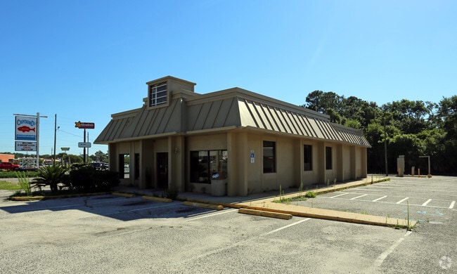
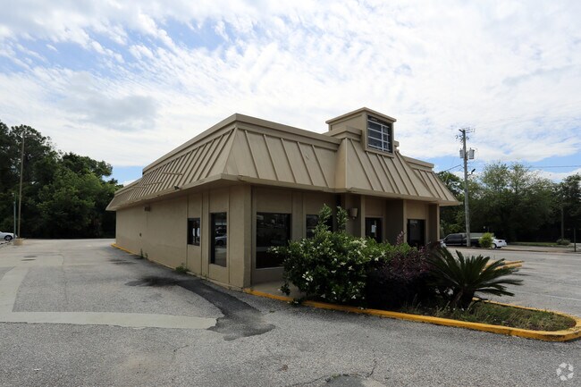
Property Record
6515 Caroline St, Milton, FL 32570

Save to a Folder
{{folder.Name}}
{{folder.ListingIds.length}} Properties
{{folder.ListingIds.length}} Property
Create a New Folder
Property Detail
6515 Caroline St
04-1N-28-0000-03700-0000
**DESCRIPTION UPDATE FOR 2024** COM AT SE COR OF 04-1N-28W THN N00*13'10W ALONG E SEC LN 500 FT THN N90*0000'W 677.59 FT THN N00*00'E 15 FT THN N90*00'W 25 FT TO POB & CONTINUE 206.94 FT TO E R/W OF HWY 90 THN S29*55'00W ALONG R/W 132.68 FT THN S90*0
Commercialacreage
SANTA ROSA
C2
Florida
B and X Area of moderate flood hazard, usually the area between the limits of the 100-year and 500-year floods.
0.70 AC
2024
Avalon Beach/Milton
2025
Pensacola
010602
Pensacola-Ferry Pass-Brent, FL
2,194 SF
NEARBY LISTINGS FOR SALE OR LEASE
DEMOGRAPHICS near 6515 Caroline St
1 mile
3 mile
5 mile
2025 Total Population
4,648
29,309
57,528
2030 Population
5,067
31,770
62,453
Pop Growth 2025-2030
+ 9.01%
+ 8.40%
+ 8.56%
Average Age
39
40
41
2025 Total Households
1,887
11,316
21,757
HH Growth 2025-2030
+ 8.96%
+ 8.21%
+ 8.40%
Median Household Inc
$60,174
$74,002
$78,074
Avg Household Size
2.40
2.50
2.60
2025 Avg HH Vehicles
1.00
2.00
2.00
Median Home Value
$173,466
$260,850
$275,031
Median Year Built
1975
1990
1993
Nearby Places
Map Layers
Map Styles
 Street
 Aerial
Layers
 Traffic
 Biking
Places
Listings with unknown addresses are not visible on the map
- Restaurants
- Banks
- Shops
- Fitness
- Groceries
PUBLIC TRANSPORTATION
AIRPORT
Pensacola International
Drive
Walk
Distance
Pensacola International
32 min
18.8 mi
Freight Ports
Port of Mobile
Drive
Walk
Distance
Port of Mobile
82 min
68.9 mi
SALE & LEASE HISTORY
LISTING DATE
SALE/LEASE

Sep 23, 2016
For Sale
Nearby Properties
Address
Land Use
TOTAL SIZE
Lot Size
Zoning
Address
Land Use
TOTAL SIZE
Lot Size
Zoning
173,250 SF
28.91 AC
C1
Address
Land Use
TOTAL SIZE
Lot Size
Zoning
80,314 SF
9.76 AC
C1
Address
Land Use
TOTAL SIZE
Lot Size
Zoning
8,223 SF
40 AC
Address
Land Use
TOTAL SIZE
Lot Size
Zoning
102,921 SF
5 AC
R3
Address
Land Use
TOTAL SIZE
Lot Size
Zoning
113,178 SF
8.61 AC
HCD
Address
Land Use
TOTAL SIZE
Lot Size
Zoning
151,842 SF
14.28 AC
C2
Address
Land Use
TOTAL SIZE
Lot Size
Zoning
113,652 SF
9.52 AC
C2
Address
Land Use
TOTAL SIZE
Lot Size
Zoning
82,878 SF
9.07 AC
HCD
Address
Land Use
TOTAL SIZE
Lot Size
Zoning
76.81 AC
R1
Address
Land Use
TOTAL SIZE
Lot Size
Zoning
98,250 SF
49.63 AC
HCD
Address
Land Use
TOTAL SIZE
Lot Size
Zoning
147,443 SF
11.44 AC
I1
Address
Land Use
TOTAL SIZE
Lot Size
Zoning
39,570 SF
0.36 AC
C1
Address
Land Use
TOTAL SIZE
Lot Size
Zoning
81,150 SF
4.86 AC
HCD
Address
Land Use
TOTAL SIZE
Lot Size
Zoning
68,026 SF
2.07 AC
RC1
Address
Land Use
TOTAL SIZE
Lot Size
Zoning
48,210 SF
8.98 AC
C2
Address
Land Use
TOTAL SIZE
Lot Size
Zoning
16,903 SF
11 AC
AG-RR
Address
Land Use
TOTAL SIZE
Lot Size
Zoning
91,887 SF
10.83 AC
C1
Address
Land Use
TOTAL SIZE
Lot Size
Zoning
10 AC
R1A
Address
Land Use
TOTAL SIZE
Lot Size
Zoning
37,820 SF
16.98 AC
HCD
Address
Land Use
TOTAL SIZE
Lot Size
Zoning
51,760 SF
5.50 AC
HCD
Address
Land Use
TOTAL SIZE
Lot Size
Zoning
40,142 SF
5.28 AC
R3
Address
Land Use
TOTAL SIZE
Lot Size
Zoning
41,105 SF
8.16 AC
HCD
Address
Land Use
TOTAL SIZE
Lot Size
Zoning
43,312 SF
15 AC
HCD
Address
Land Use
TOTAL SIZE
Lot Size
Zoning
46,613 SF
5.72 AC
C1
Address
Land Use
TOTAL SIZE
Lot Size
Zoning
72,208 SF
66.85 AC
C2
Address
Land Use
TOTAL SIZE
Lot Size
Zoning
60,717 SF
4.43 AC
HCD
Address
Land Use
TOTAL SIZE
Lot Size
Zoning
15 AC
R1A
Address
Land Use
TOTAL SIZE
Lot Size
Zoning
22.09 AC
PE
Address
Land Use
TOTAL SIZE
Lot Size
Zoning
52,334 SF
10 AC
HCD
The World's #1 Commercial Real Estate Marketplace
Connect with us
© 2026 CoStar Group
The information above has been obtained from sources believed reliable. While we do not doubt its accuracy we have not verified it and make no guarantee, warranty or representation about it. It is your responsibility to independently confirm its accuracy and completeness. Any projections, opinions, assumptions, or estimates used are for example only and do not represent the current or future performance of the property. The value of this transaction to you depends on tax and other factors which should be evaluated by your tax, financial, and legal advisors. You and your advisors should conduct a careful, independent investigation of the property to determine to your satisfaction the suitability of the property for your needs.