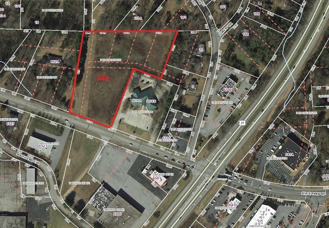
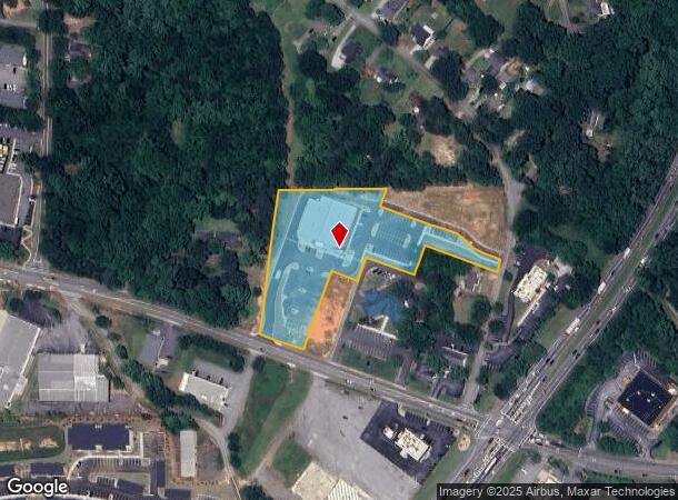
Property Record
6520 State Park Rd, Travelers Rest, SC 29690
NEARBY LISTINGS FOR SALE OR LEASE
Property Detail
6520 State Park Rd
Greenville-Anderson-Mauldin, SC
Subdivision Of Property Of J S Garrett
0491.00-03-032.02
MAP 0491.00; A
Storebuilding
Greenville
X
South Carolina
45045C0310E
032.02
2024
3.14 AC
2024
Travelers Rest
003906
Greenville/Spartanburg
DEMOGRAPHICS near 6520 State Park Rd
1 Mile
3 Mile
5 Mile
2024 Total Population
3,492
17,989
44,934
2029 Population
3,877
19,760
49,460
Pop Growth 2024-2029
+ 11.03%
+ 9.84%
+ 10.07%
Average Age
39
40
41
2024 Total Households
1,386
6,261
17,571
HH Growth 2024-2029
+ 11.18%
+ 10.65%
+ 10.40%
Median Household Inc
$36,166
$66,223
$60,905
Avg Household Size
2.50
2.40
2.40
2024 Avg HH Vehicles
2.00
2.00
2.00
Median Home Value
$250,000
$286,997
$248,400
Median Year Built
1992
1995
1990
Nearby Places
- Restaurants
- Banks
- Shops
- Fitness
- Groceries
PUBLIC TRANSPORTATION
COMMUTER RAIL
Greenville Amtrak Station (Crescent - Amtrak)
DRIVE
WALK
Distance
Greenville Amtrak Station (Crescent - Amtrak)
16 min
8.7 mi
AIRPORT
Greenville Spartanburg International
DRIVE
WALK
Distance
Greenville Spartanburg International
37 min
22.0 mi
Freight Ports
North Charleston Terminal
DRIVE
WALK
Distance
North Charleston Terminal
244 min
212.6 mi
SALE & LEASE HISTORY
LISTING DATE
SALE/LEASE

Sep 24, 2016
For Sale
Apr 05, 2017
For Sale
Nearby Properties
Address
Land Use
TOTAL SIZE
Lot Size
Zoning
Address
Land Use
TOTAL SIZE
Lot Size
Zoning
22.58 AC
RRROW
Address
Land Use
TOTAL SIZE
Lot Size
Zoning
703.30 AC
RS
Address
Land Use
TOTAL SIZE
Lot Size
Zoning
3.93 AC
R10
Address
Land Use
TOTAL SIZE
Lot Size
Zoning
19.25 AC
R15
Address
Land Use
TOTAL SIZE
Lot Size
Zoning
14.40 AC
I1
Address
Land Use
TOTAL SIZE
Lot Size
Zoning
7.56 AC
C2
Address
Land Use
TOTAL SIZE
Lot Size
Zoning
Address
Land Use
TOTAL SIZE
Lot Size
Zoning
Address
Land Use
TOTAL SIZE
Lot Size
Zoning
37 AC
S1
Address
Land Use
TOTAL SIZE
Lot Size
Zoning
149.88 AC
ESDPM
Address
Land Use
TOTAL SIZE
Lot Size
Zoning
159 AC
UNZONED
Address
Land Use
TOTAL SIZE
Lot Size
Zoning
6.22 AC
I1
Address
Land Use
TOTAL SIZE
Lot Size
Zoning
55.70 AC
UNZONED
Address
Land Use
TOTAL SIZE
Lot Size
Zoning
4.97 AC
C2
Address
Land Use
TOTAL SIZE
Lot Size
Zoning
9.60 AC
I1
Address
Land Use
TOTAL SIZE
Lot Size
Zoning
1,491 SF
27.82 AC
R15
Address
Land Use
TOTAL SIZE
Lot Size
Zoning
11.56 AC
I1
Address
Land Use
TOTAL SIZE
Lot Size
Zoning
34.67 AC
I1
Address
Land Use
TOTAL SIZE
Lot Size
Zoning
24.45 AC
I1
Address
Land Use
TOTAL SIZE
Lot Size
Zoning
58.29 AC
PD
Address
Land Use
TOTAL SIZE
Lot Size
Zoning
2.58 AC
PDR
Address
Land Use
TOTAL SIZE
Lot Size
Zoning
273.14 AC
ESDPM
Address
Land Use
TOTAL SIZE
Lot Size
Zoning
15.31 AC
UNZONED
Address
Land Use
TOTAL SIZE
Lot Size
Zoning
4.40 AC
I1
Address
Land Use
TOTAL SIZE
Lot Size
Zoning
58.70 AC
R75
Address
Land Use
TOTAL SIZE
Lot Size
Zoning
19.10 AC
NZ
Address
Land Use
TOTAL SIZE
Lot Size
Zoning
30.60 AC
I1
Address
Land Use
TOTAL SIZE
Lot Size
Zoning
19.60 AC
NZ
Address
Land Use
TOTAL SIZE
Lot Size
Zoning
19.96 AC
PD
Address
Land Use
TOTAL SIZE
Lot Size
Zoning
15.30 AC
RRROW
The World's #1 Commercial Real Estate Marketplace
Connect with us
© 2025 CoStar Group
The information above has been obtained from sources believed reliable. While we do not doubt its accuracy we have not verified it and make no guarantee, warranty or representation about it. It is your responsibility to independently confirm its accuracy and completeness. Any projections, opinions, assumptions, or estimates used are for example only and do not represent the current or future performance of the property. The value of this transaction to you depends on tax and other factors which should be evaluated by your tax, financial, and legal advisors. You and your advisors should conduct a careful, independent investigation of the property to determine to your satisfaction the suitability of the property for your needs.