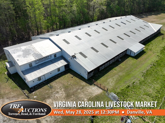
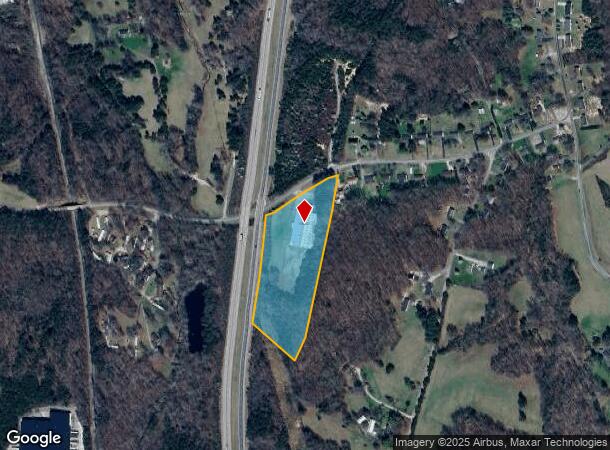
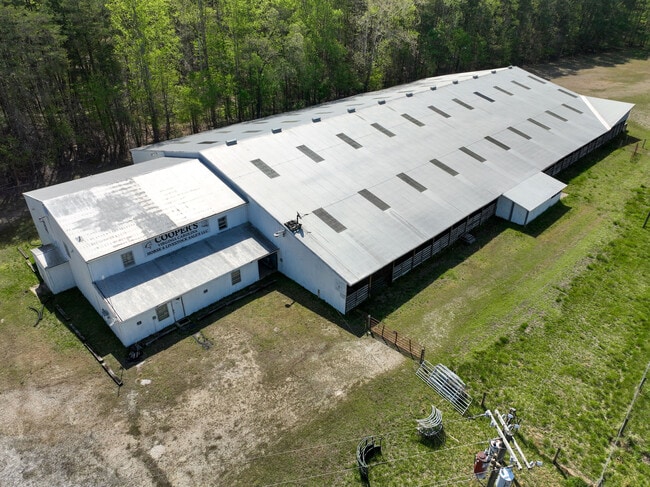
Property Record
652 Livestock Rd, Danville, VA 24540
NEARBY LISTINGS FOR SALE OR LEASE
-
-
View all Danville listings for sale on LoopNet.com
Property Detail
652 Livestock Rd
2420-94-1253
ST RD 721 PT TR 1
Industrialgeneral
Pittsylvania
X
Virginia
51143C0536E
6.38 AC
2025
Virginia South Central
2025
Other Market Areas
011400
Danville, VA
5,606 SF
DEMOGRAPHICS near 652 Livestock Rd
1 Mile
3 Mile
5 Mile
2024 Total Population
998
7,553
25,010
2029 Population
990
7,406
24,465
Pop Growth 2024-2029
(0.80%)
(1.95%)
(2.18%)
Average Age
44
43
42
2024 Total Households
412
3,151
10,624
HH Growth 2024-2029
(0.73%)
(2.00%)
(2.26%)
Median Household Inc
$61,596
$55,423
$43,611
Avg Household Size
2.40
2.30
2.30
2024 Avg HH Vehicles
2.00
2.00
2.00
Median Home Value
$148,226
$150,099
$129,066
Median Year Built
1980
1981
1973
Nearby Places
Map Layers
Map Styles
 Street
 Aerial
- Restaurants
- Banks
- Shops
- Fitness
- Groceries
PUBLIC TRANSPORTATION
COMMUTER RAIL
DRIVE
WALK
Distance
13 min
7.2 mi
SALE & LEASE HISTORY
LISTING DATE
SALE/LEASE

May 01, 2025
For Sale
Nearby Properties
Address
Land Use
TOTAL SIZE
Lot Size
Zoning
Address
Land Use
TOTAL SIZE
Lot Size
Zoning
12.20 AC
B-2
Address
Land Use
TOTAL SIZE
Lot Size
Zoning
2,516 SF
19.75 AC
DZ
Address
Land Use
TOTAL SIZE
Lot Size
Zoning
75,816 SF
7.04 AC
COND MULTI
Address
Land Use
TOTAL SIZE
Lot Size
Zoning
73,290 SF
5.94 AC
RMF
Address
Land Use
TOTAL SIZE
Lot Size
Zoning
21.40 AC
A-1
Address
Land Use
TOTAL SIZE
Lot Size
Zoning
8.52 AC
B-2
Address
Land Use
TOTAL SIZE
Lot Size
Zoning
20.17 AC
M-1
Address
Land Use
TOTAL SIZE
Lot Size
Zoning
43,942 SF
14.62 AC
NEIGHBORHO
Address
Land Use
TOTAL SIZE
Lot Size
Zoning
34,653 SF
8.87 AC
NEIGHBORHO
Address
Land Use
TOTAL SIZE
Lot Size
Zoning
2,788 SF
5.38 AC
RMF
Address
Land Use
TOTAL SIZE
Lot Size
Zoning
4.08 AC
B-2
Address
Land Use
TOTAL SIZE
Lot Size
Zoning
129,864 SF
14.35 AC
M-1
Address
Land Use
TOTAL SIZE
Lot Size
Zoning
14,550 SF
2.06 AC
HIGHWAY RE
Address
Land Use
TOTAL SIZE
Lot Size
Zoning
23,046 SF
1.38 AC
OLD TOWN R
Address
Land Use
TOTAL SIZE
Lot Size
Zoning
41,490 SF
2.91 AC
HIGHWAY RE
Address
Land Use
TOTAL SIZE
Lot Size
Zoning
5,980 SF
2.58 AC
B-2
Address
Land Use
TOTAL SIZE
Lot Size
Zoning
7,440 SF
3.89 AC
MULTI-FAMI
Address
Land Use
TOTAL SIZE
Lot Size
Zoning
2,128 SF
9.59 AC
B-2
Address
Land Use
TOTAL SIZE
Lot Size
Zoning
9,015 SF
1.92 AC
R-1
Address
Land Use
TOTAL SIZE
Lot Size
Zoning
40,000 SF
4.39 AC
B-2
Address
Land Use
TOTAL SIZE
Lot Size
Zoning
20,412 SF
5.14 AC
B-2
Address
Land Use
TOTAL SIZE
Lot Size
Zoning
5,194 SF
2.80 AC
B-2
Address
Land Use
TOTAL SIZE
Lot Size
Zoning
9,140 SF
7 AC
R-1
Address
Land Use
TOTAL SIZE
Lot Size
Zoning
97,425 SF
10 AC
M-1
Address
Land Use
TOTAL SIZE
Lot Size
Zoning
11,682 SF
2.05 AC
OLD TOWN R
Address
Land Use
TOTAL SIZE
Lot Size
Zoning
3.15 AC
B-2
Address
Land Use
TOTAL SIZE
Lot Size
Zoning
8,000 SF
1.15 AC
B-2
Address
Land Use
TOTAL SIZE
Lot Size
Zoning
1.61 AC
RMF
Address
Land Use
TOTAL SIZE
Lot Size
Zoning
8,320 SF
2.36 AC
B-2
The World's #1 Commercial Real Estate Marketplace
Connect with us
© 2025 CoStar Group
The information above has been obtained from sources believed reliable. While we do not doubt its accuracy we have not verified it and make no guarantee, warranty or representation about it. It is your responsibility to independently confirm its accuracy and completeness. Any projections, opinions, assumptions, or estimates used are for example only and do not represent the current or future performance of the property. The value of this transaction to you depends on tax and other factors which should be evaluated by your tax, financial, and legal advisors. You and your advisors should conduct a careful, independent investigation of the property to determine to your satisfaction the suitability of the property for your needs.