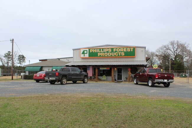
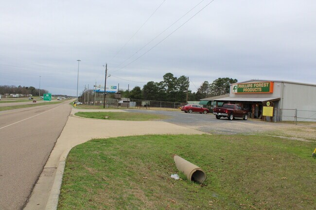
Property Record
652 Palmer Dr, Hooks, TX 75561

Property Detail
652 Palmer Dr
04280013100
GEORGE COLLUM A-119 6248/297 06/18/12 BLK/TRACT 93 18.2 ACRES
Commercialnec
Bowie
B and X Area of moderate flood hazard, usually the area between the limits of the 100-year and 500-year floods.
Texas
2024
18.20 AC
2025
Texas East Area
011302
Other Market Areas
19,669 SF
Texarkana, TX-AR
NEARBY LISTINGS FOR SALE OR LEASE
DEMOGRAPHICS near 652 Palmer Dr
1 mile
3 mile
5 mile
2025 Total Population
1,359
3,617
4,781
2030 Population
1,351
3,587
4,753
Pop Growth 2025-2030
(0.59%)
(0.83%)
(0.59%)
Average Age
40
40
41
2025 Total Households
582
1,483
1,941
HH Growth 2025-2030
(0.52%)
(0.81%)
(0.62%)
Median Household Inc
$50,278
$52,692
$54,895
Avg Household Size
2.30
2.40
2.40
2025 Avg HH Vehicles
2.00
2.00
2.00
Median Home Value
$147,852
$135,370
$146,153
Median Year Built
1981
1976
1977
Nearby Places
Map Layers
Map Styles
 Street
 Aerial
Transit
 Traffic
 Biking
Places
Listings with unknown addresses are not visible on the map
- Restaurants
- Banks
- Shops
- Fitness
- Groceries
PUBLIC TRANSPORTATION
AIRPORT
Texarkana Regional-Webb Field
Drive
Walk
Distance
Texarkana Regional-Webb Field
32 min
23.2 mi
Freight Ports
Port of Shreveport
Drive
Walk
Distance
Port of Shreveport
126 min
111.2 mi
SALE & LEASE HISTORY
LISTING DATE
SALE/LEASE

Feb 19, 2020
For Sale
Nearby Properties
Address
Land Use
TOTAL SIZE
Lot Size
Zoning
Address
Land Use
TOTAL SIZE
Lot Size
Zoning
16.86 AC
Address
Land Use
TOTAL SIZE
Lot Size
Zoning
5.20 AC
Address
Land Use
TOTAL SIZE
Lot Size
Zoning
262,312 SF
279.97 AC
Address
Land Use
TOTAL SIZE
Lot Size
Zoning
8.96 AC
Address
Land Use
TOTAL SIZE
Lot Size
Zoning
6.60 AC
Address
Land Use
TOTAL SIZE
Lot Size
Zoning
224,000 SF
146.94 AC
Address
Land Use
TOTAL SIZE
Lot Size
Zoning
27,000 SF
13.80 AC
Address
Land Use
TOTAL SIZE
Lot Size
Zoning
834.91 AC
Address
Land Use
TOTAL SIZE
Lot Size
Zoning
15,338 SF
2 AC
Address
Land Use
TOTAL SIZE
Lot Size
Zoning
79,784 SF
10 AC
Address
Land Use
TOTAL SIZE
Lot Size
Zoning
9,114 SF
6.76 AC
Address
Land Use
TOTAL SIZE
Lot Size
Zoning
26,684 SF
22.52 AC
Address
Land Use
TOTAL SIZE
Lot Size
Zoning
18,855 SF
10.25 AC
Address
Land Use
TOTAL SIZE
Lot Size
Zoning
5,765 SF
2.28 AC
Address
Land Use
TOTAL SIZE
Lot Size
Zoning
35.31 AC
Address
Land Use
TOTAL SIZE
Lot Size
Zoning
38,048 SF
4.06 AC
Address
Land Use
TOTAL SIZE
Lot Size
Zoning
19,600 SF
2.40 AC
Address
Land Use
TOTAL SIZE
Lot Size
Zoning
10,416 SF
1.19 AC
Address
Land Use
TOTAL SIZE
Lot Size
Zoning
10,810 SF
1.12 AC
Address
Land Use
TOTAL SIZE
Lot Size
Zoning
7,892 SF
1.75 AC
Address
Land Use
TOTAL SIZE
Lot Size
Zoning
10,152 SF
1.27 AC
Address
Land Use
TOTAL SIZE
Lot Size
Zoning
9,012 SF
1.44 AC
Address
Land Use
TOTAL SIZE
Lot Size
Zoning
37,920 SF
1.62 AC
Address
Land Use
TOTAL SIZE
Lot Size
Zoning
5,550 SF
210.88 AC
Address
Land Use
TOTAL SIZE
Lot Size
Zoning
864 SF
12.18 AC
Address
Land Use
TOTAL SIZE
Lot Size
Zoning
28,678 SF
9.81 AC
The World's #1 Commercial Real Estate Marketplace
Connect with us
© 2026 CoStar Group
The information above has been obtained from sources believed reliable. While we do not doubt its accuracy we have not verified it and make no guarantee, warranty or representation about it. It is your responsibility to independently confirm its accuracy and completeness. Any projections, opinions, assumptions, or estimates used are for example only and do not represent the current or future performance of the property. The value of this transaction to you depends on tax and other factors which should be evaluated by your tax, financial, and legal advisors. You and your advisors should conduct a careful, independent investigation of the property to determine to your satisfaction the suitability of the property for your needs.