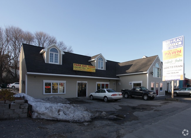
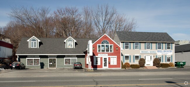
Property Record
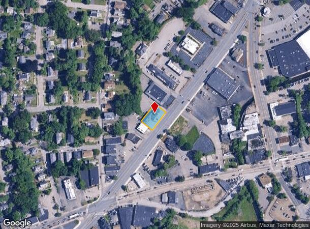
652 Park Ave, Worcester, MA 01603

NEARBY LISTINGS FOR SALE OR LEASE
Property Detail
652 Park Ave
WORC-000008-000025-000010B
Worcester
Officebuilding
Massachusetts
AE
10b
25027C0802E
0.23 AC
2025
Worcester Metro
2025
Boston
731002
Worcester, MA
5,717 SF
DEMOGRAPHICS near 652 Park Ave
1 Mile
3 Mile
5 Mile
2024 Total Population
21,863
130,888
216,741
2029 Population
21,446
128,861
214,086
Pop Growth 2024-2029
(1.91%)
(1.55%)
(1.22%)
Average Age
38
37
39
2024 Total Households
8,374
49,359
83,963
HH Growth 2024-2029
(1.86%)
(1.54%)
(1.20%)
Median Household Inc
$41,683
$53,888
$64,442
Avg Household Size
2.40
2.40
2.40
2024 Avg HH Vehicles
1.00
1.00
1.00
Median Home Value
$267,480
$309,525
$318,779
Median Year Built
1947
1948
1952
Nearby Places
Map Layers
Map Styles
 Street
 Aerial
- Restaurants
- Banks
- Shops
- Fitness
- Groceries
PUBLIC TRANSPORTATION
COMMUTER RAIL
DRIVE
WALK
Distance
5 min
2.8 mi
Worcester (Framingham/Worcester Line - Massachusetts Bay Transportation Authority Commuter Rail (Purple Line))
DRIVE
WALK
Distance
Worcester (Framingham/Worcester Line - Massachusetts Bay Transportation Authority Commuter Rail (Purple Line))
6 min
2.9 mi
AIRPORT
Worcester Regional
DRIVE
WALK
Distance
Worcester Regional
11 min
4.4 mi
Freight Ports
Port of Boston
DRIVE
WALK
Distance
Port of Boston
65 min
48.0 mi
Nearby Properties
Address
Land Use
TOTAL SIZE
Lot Size
Zoning
Address
Land Use
TOTAL SIZE
Lot Size
Zoning
669,637 SF
17.46 AC
BG-6
Address
Land Use
TOTAL SIZE
Lot Size
Zoning
49.51 AC
IN-S
Address
Land Use
TOTAL SIZE
Lot Size
Zoning
381,440 SF
2.74 AC
BG-6
Address
Land Use
TOTAL SIZE
Lot Size
Zoning
612,538 SF
3.98 AC
BG-6
Address
Land Use
TOTAL SIZE
Lot Size
Zoning
244,486 SF
42.64 AC
RL-7
Address
Land Use
TOTAL SIZE
Lot Size
Zoning
142.98 AC
Address
Land Use
TOTAL SIZE
Lot Size
Zoning
3.85 AC
RG-5
Address
Land Use
TOTAL SIZE
Lot Size
Zoning
25,000 SF
99.10 AC
MG-.5
Address
Land Use
TOTAL SIZE
Lot Size
Zoning
117,645 SF
3.11 AC
BO-1
Address
Land Use
TOTAL SIZE
Lot Size
Zoning
311,604 SF
2.37 AC
MG-2
Address
Land Use
TOTAL SIZE
Lot Size
Zoning
1,760 SF
105.54 AC
ML10
Address
Land Use
TOTAL SIZE
Lot Size
Zoning
157,385 SF
3.45 AC
BG-6
Address
Land Use
TOTAL SIZE
Lot Size
Zoning
164,378 SF
21.40 AC
Address
Land Use
TOTAL SIZE
Lot Size
Zoning
15.42 AC
RG-5
Address
Land Use
TOTAL SIZE
Lot Size
Zoning
19,319 SF
10.67 AC
RG-5
Address
Land Use
TOTAL SIZE
Lot Size
Zoning
177.12 AC
RL-7
Address
Land Use
TOTAL SIZE
Lot Size
Zoning
591,515 SF
33.04 AC
MG-1
Address
Land Use
TOTAL SIZE
Lot Size
Zoning
3.55 AC
RG-5
Address
Land Use
TOTAL SIZE
Lot Size
Zoning
69.46 AC
RS-7
Address
Land Use
TOTAL SIZE
Lot Size
Zoning
159,355 SF
207.62 AC
RL-7
Address
Land Use
TOTAL SIZE
Lot Size
Zoning
68.34 AC
ML10
Address
Land Use
TOTAL SIZE
Lot Size
Zoning
3.43 AC
ML10
Address
Land Use
TOTAL SIZE
Lot Size
Zoning
3.97 AC
BG-6
Address
Land Use
TOTAL SIZE
Lot Size
Zoning
37,093 SF
5.41 AC
RG-5
Address
Land Use
TOTAL SIZE
Lot Size
Zoning
181,408 SF
1.50 AC
BG-6
Address
Land Use
TOTAL SIZE
Lot Size
Zoning
78.19 AC
RL-7
Address
Land Use
TOTAL SIZE
Lot Size
Zoning
7,700 SF
80.72 AC
ML-.5
Address
Land Use
TOTAL SIZE
Lot Size
Zoning
41.84 AC
Address
Land Use
TOTAL SIZE
Lot Size
Zoning
643,250 SF
35.17 AC
RL-7
Address
Land Use
TOTAL SIZE
Lot Size
Zoning
175,200 SF
2.26 AC
BL-1
The World's #1 Commercial Real Estate Marketplace
Connect with us
© 2026 CoStar Group
The information above has been obtained from sources believed reliable. While we do not doubt its accuracy we have not verified it and make no guarantee, warranty or representation about it. It is your responsibility to independently confirm its accuracy and completeness. Any projections, opinions, assumptions, or estimates used are for example only and do not represent the current or future performance of the property. The value of this transaction to you depends on tax and other factors which should be evaluated by your tax, financial, and legal advisors. You and your advisors should conduct a careful, independent investigation of the property to determine to your satisfaction the suitability of the property for your needs.