Property Record
6520 410Th St, North Branch, MN 55056
NEARBY LISTINGS FOR SALE OR LEASE
-
-
View all North Branch listings for sale on LoopNet.com
Property Detail
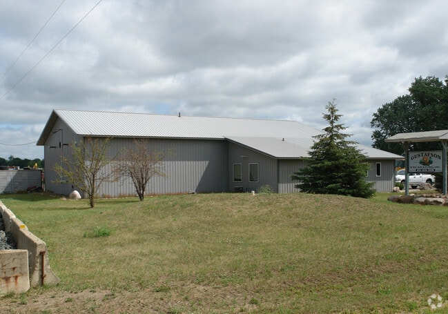
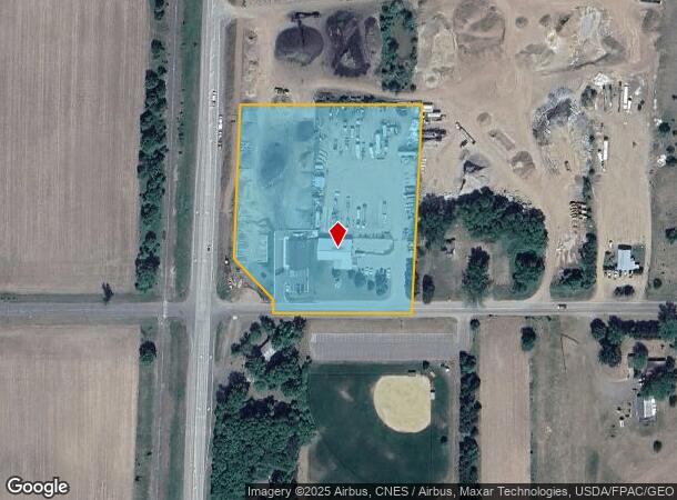
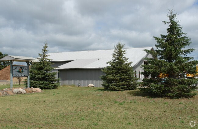
6520 410Th St
11-00060-20
Sw1/4 S4 T35 R21
Commercialnec
THAT PT OF SW 1/4 OF SW 1/4 DESC AS FOL: COMM AT SW COR OF SAID SW 1/4 OF SW 1/4;TH ON AN ASSUM BEAR OF E ALONG S LINE OF
X
Chisago
27025C0165D
Minnesota
2025
5.10 AC
2024
Chisago County
110302
Minneapolis/St Paul
4,776 SF
Minneapolis-St. Paul-Bloomington, MN-WI
DEMOGRAPHICS near 6520 410Th St
1 Mile
3 Mile
5 Mile
2024 Total Population
782
8,135
14,019
2029 Population
826
8,613
14,878
Pop Growth 2024-2029
+ 5.63%
+ 5.88%
+ 6.13%
Average Age
38
38
39
2024 Total Households
269
3,030
5,129
HH Growth 2024-2029
+ 5.58%
+ 6.01%
+ 6.20%
Median Household Inc
$134,782
$89,993
$93,244
Avg Household Size
2.70
2.60
2.70
2024 Avg HH Vehicles
3.00
2.00
2.00
Median Home Value
$264,378
$256,068
$260,101
Median Year Built
1992
1992
1993
Nearby Places
Map Layers
Map Styles
 Street
 Aerial
- Restaurants
- Banks
- Shops
- Fitness
- Groceries
Nearby Properties
Address
Land Use
TOTAL SIZE
Lot Size
Zoning
Address
Land Use
TOTAL SIZE
Lot Size
Zoning
158,203 SF
74.66 AC
RR
Address
Land Use
TOTAL SIZE
Lot Size
Zoning
138,977 SF
58.21 AC
R1
Address
Land Use
TOTAL SIZE
Lot Size
Zoning
2,700 SF
52.19 AC
I2
Address
Land Use
TOTAL SIZE
Lot Size
Zoning
52,671 SF
8.94 AC
B3
Address
Land Use
TOTAL SIZE
Lot Size
Zoning
150,000 SF
27.15 AC
Address
Land Use
TOTAL SIZE
Lot Size
Zoning
61,103 SF
6.94 AC
Address
Land Use
TOTAL SIZE
Lot Size
Zoning
42,052 SF
3.89 AC
Address
Land Use
TOTAL SIZE
Lot Size
Zoning
41,062 SF
2.82 AC
Address
Land Use
TOTAL SIZE
Lot Size
Zoning
41,062 SF
2.36 AC
Address
Land Use
TOTAL SIZE
Lot Size
Zoning
41,062 SF
3.86 AC
Address
Land Use
TOTAL SIZE
Lot Size
Zoning
41,062 SF
2.52 AC
Address
Land Use
TOTAL SIZE
Lot Size
Zoning
53,041 SF
5.43 AC
B2
Address
Land Use
TOTAL SIZE
Lot Size
Zoning
58,368 SF
3.38 AC
R3
Address
Land Use
TOTAL SIZE
Lot Size
Zoning
80,358 SF
8.31 AC
B2
Address
Land Use
TOTAL SIZE
Lot Size
Zoning
58,024 SF
3.30 AC
R3
Address
Land Use
TOTAL SIZE
Lot Size
Zoning
45,756 SF
0.40 AC
CBD
Address
Land Use
TOTAL SIZE
Lot Size
Zoning
42,822 SF
3.04 AC
R3
Address
Land Use
TOTAL SIZE
Lot Size
Zoning
38,678 SF
2.78 AC
R3
Address
Land Use
TOTAL SIZE
Lot Size
Zoning
20,934 SF
1.92 AC
B3
Address
Land Use
TOTAL SIZE
Lot Size
Zoning
18,144 SF
2.50 AC
Address
Land Use
TOTAL SIZE
Lot Size
Zoning
135,510 SF
15.95 AC
B3
Address
Land Use
TOTAL SIZE
Lot Size
Zoning
103,679 SF
17.47 AC
I
Address
Land Use
TOTAL SIZE
Lot Size
Zoning
1,820 SF
17.90 AC
R4
Address
Land Use
TOTAL SIZE
Lot Size
Zoning
19,006 SF
5.03 AC
RR
Address
Land Use
TOTAL SIZE
Lot Size
Zoning
57,840 SF
10.18 AC
I2
Address
Land Use
TOTAL SIZE
Lot Size
Zoning
28,670 SF
2.51 AC
R3
Address
Land Use
TOTAL SIZE
Lot Size
Zoning
6,000 SF
20 AC
AG1
Address
Land Use
TOTAL SIZE
Lot Size
Zoning
12,000 SF
8.70 AC
RR
Address
Land Use
TOTAL SIZE
Lot Size
Zoning
8,246 SF
1.90 AC
B3
Address
Land Use
TOTAL SIZE
Lot Size
Zoning
41,260 SF
0.05 AC
I2
The World's #1 Commercial Real Estate Marketplace
Connect with us
© 2026 CoStar Group
The information above has been obtained from sources believed reliable. While we do not doubt its accuracy we have not verified it and make no guarantee, warranty or representation about it. It is your responsibility to independently confirm its accuracy and completeness. Any projections, opinions, assumptions, or estimates used are for example only and do not represent the current or future performance of the property. The value of this transaction to you depends on tax and other factors which should be evaluated by your tax, financial, and legal advisors. You and your advisors should conduct a careful, independent investigation of the property to determine to your satisfaction the suitability of the property for your needs.