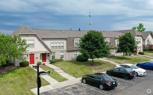
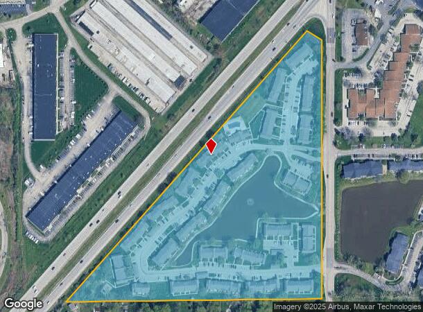
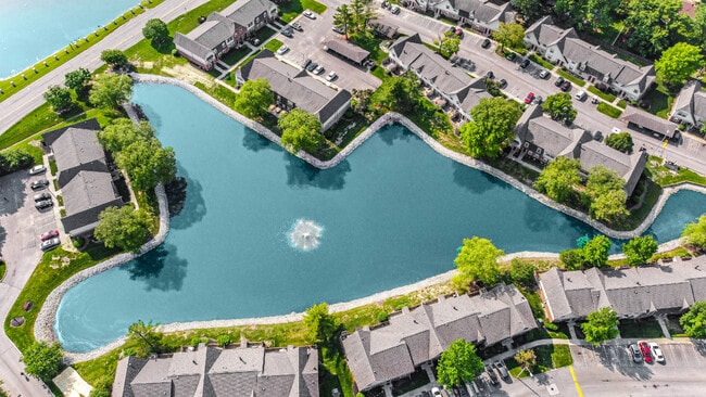
Property Record
6520 Graham Rd, Indianapolis, IN 46220
NEARBY LISTINGS FOR SALE OR LEASE
-
-
View all Indianapolis listings for sale on LoopNet.com
Property Detail
6520 Graham Rd
Indianapolis-Carmel-Greenwood, IN
PT E1/2 NE1/4 S33 T17 R4 BEG 414.041FT N OF SE CORW 1144.957FT NE 1573.273FT SERLY115.354FT S 1107.703FT TO BEG 16.526AC
49-02-33-115-139.000-800
Marion
Apartment
Indiana
2023
16.53 AC
2024
Devonshire
321400
Indianapolis
2,044 SF
DEMOGRAPHICS near 6520 Graham Rd
1 Mile
3 Mile
5 Mile
2024 Total Population
6,312
62,694
193,362
2029 Population
6,170
61,798
193,216
Pop Growth 2024-2029
(2.25%)
(1.43%)
(0.08%)
Average Age
40
40
39
2024 Total Households
2,462
29,015
85,756
HH Growth 2024-2029
(2.27%)
(1.41%)
(0.18%)
Median Household Inc
$101,581
$67,344
$61,636
Avg Household Size
2.50
2.10
2.20
2024 Avg HH Vehicles
2.00
2.00
2.00
Median Home Value
$309,208
$256,666
$236,962
Median Year Built
1967
1973
1971
Nearby Places
Map Layers
Map Styles
 Street
 Aerial
- Restaurants
- Banks
- Shops
- Fitness
- Groceries
PUBLIC TRANSPORTATION
AIRPORT
Indianapolis International
DRIVE
WALK
Distance
Indianapolis International
41 min
24.4 mi
Freight Ports
Port of Toledo
DRIVE
WALK
Distance
Port of Toledo
253 min
215.3 mi
Nearby Properties
Address
Land Use
TOTAL SIZE
Lot Size
Zoning
Address
Land Use
TOTAL SIZE
Lot Size
Zoning
366,825 SF
26.60 AC
ZO01
Address
Land Use
TOTAL SIZE
Lot Size
Zoning
21,742 SF
39.35 AC
ZO01
Address
Land Use
TOTAL SIZE
Lot Size
Zoning
8,551 SF
45.92 AC
ZO01
Address
Land Use
TOTAL SIZE
Lot Size
Zoning
16,704 SF
109.83 AC
ZO01
Address
Land Use
TOTAL SIZE
Lot Size
Zoning
4,246 SF
89.83 AC
ZO01
Address
Land Use
TOTAL SIZE
Lot Size
Zoning
4,146 SF
45.91 AC
ZO01
Address
Land Use
TOTAL SIZE
Lot Size
Zoning
10,911 SF
11.56 AC
ZO01
Address
Land Use
TOTAL SIZE
Lot Size
Zoning
5,314 SF
13.92 AC
ZO01
Address
Land Use
TOTAL SIZE
Lot Size
Zoning
8,157 SF
113.93 AC
ZO01
Address
Land Use
TOTAL SIZE
Lot Size
Zoning
6,229 SF
36.20 AC
ZO01
Address
Land Use
TOTAL SIZE
Lot Size
Zoning
6,366 SF
19.40 AC
ZO01
Address
Land Use
TOTAL SIZE
Lot Size
Zoning
5,149 SF
10.56 AC
ZO01
Address
Land Use
TOTAL SIZE
Lot Size
Zoning
143,890 SF
37.81 AC
ZO01
Address
Land Use
TOTAL SIZE
Lot Size
Zoning
91,717 SF
37.30 AC
Address
Land Use
TOTAL SIZE
Lot Size
Zoning
76,657 SF
9.45 AC
ZO01
Address
Land Use
TOTAL SIZE
Lot Size
Zoning
118,729 SF
13.39 AC
ZO01
Address
Land Use
TOTAL SIZE
Lot Size
Zoning
151,823 SF
57.55 AC
ZO01
Address
Land Use
TOTAL SIZE
Lot Size
Zoning
23,452 SF
14.94 AC
ZO01
Address
Land Use
TOTAL SIZE
Lot Size
Zoning
24,112 SF
5.22 AC
ZO01
Address
Land Use
TOTAL SIZE
Lot Size
Zoning
13,087 SF
57.88 AC
Address
Land Use
TOTAL SIZE
Lot Size
Zoning
118,439 SF
10.88 AC
ZO01
Address
Land Use
TOTAL SIZE
Lot Size
Zoning
260,937 SF
24.61 AC
ZO01
Address
Land Use
TOTAL SIZE
Lot Size
Zoning
5,110 SF
27.06 AC
Address
Land Use
TOTAL SIZE
Lot Size
Zoning
1,120 SF
6.50 AC
ZO01
Address
Land Use
TOTAL SIZE
Lot Size
Zoning
6.73 AC
ZO01
Address
Land Use
TOTAL SIZE
Lot Size
Zoning
260 SF
17.56 AC
ZO01
Address
Land Use
TOTAL SIZE
Lot Size
Zoning
13,789 SF
3.93 AC
ZO01
Address
Land Use
TOTAL SIZE
Lot Size
Zoning
2,313 SF
35.45 AC
ZO01
Address
Land Use
TOTAL SIZE
Lot Size
Zoning
134,072 SF
21.45 AC
ZO01
Address
Land Use
TOTAL SIZE
Lot Size
Zoning
155,344 SF
8.77 AC
ZO01
The World's #1 Commercial Real Estate Marketplace
Connect with us
© 2026 CoStar Group
The information above has been obtained from sources believed reliable. While we do not doubt its accuracy we have not verified it and make no guarantee, warranty or representation about it. It is your responsibility to independently confirm its accuracy and completeness. Any projections, opinions, assumptions, or estimates used are for example only and do not represent the current or future performance of the property. The value of this transaction to you depends on tax and other factors which should be evaluated by your tax, financial, and legal advisors. You and your advisors should conduct a careful, independent investigation of the property to determine to your satisfaction the suitability of the property for your needs.