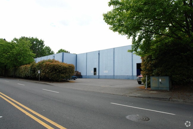
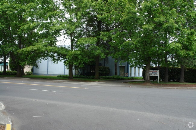
Property Record
6520 N Basin Ave, Portland, OR 97217


Property Detail
6520 N Basin Ave
R315693
SECTION 17 1N 1E, TL 900 1.00 ACRES
Industrialgeneral
Multnomah
GI2
Oregon
B and X Area of moderate flood hazard, usually the area between the limits of the 100-year and 500-year floods.
1 AC
2025
Hayden Island/Swan Island
2025
Portland
980000
Portland-Vancouver-Hillsboro, OR-WA
19,360 SF
NEARBY LISTINGS FOR SALE OR LEASE
DEMOGRAPHICS near 6520 N Basin Ave
1 mile
3 mile
5 mile
2025 Total Population
10,974
99,762
269,368
2030 Population
10,854
99,534
269,493
Pop Growth 2025-2030
(1.09%)
(0.23%)
+ 0.05%
Average Age
36
38
40
2025 Total Households
3,507
44,098
127,583
HH Growth 2025-2030
(1.74%)
(0.29%)
+ 0.09%
Median Household Inc
$117,499
$94,924
$91,797
Avg Household Size
2.50
2.10
2.00
2025 Avg HH Vehicles
2.00
2.00
1.00
Median Home Value
$629,817
$628,354
$709,612
Median Year Built
1947
1963
1973
Nearby Places
Map Layers
Map Styles
 Street
 Aerial
Transit
 Traffic
 Biking
Places
Listings with unknown addresses are not visible on the map
- Restaurants
- Banks
- Shops
- Fitness
- Groceries
PUBLIC TRANSPORTATION
COMMUTER RAIL
Drive
Walk
Distance
11 min
4.6 mi
Drive
Walk
Distance
18 min
9.1 mi
AIRPORT
Portland International
Drive
Walk
Distance
Portland International
25 min
11.3 mi
Freight Ports
Port of Portland
Drive
Walk
Distance
Port of Portland
12 min
5.6 mi
Nearby Properties
Address
Land Use
TOTAL SIZE
Lot Size
Zoning
Address
Land Use
TOTAL SIZE
Lot Size
Zoning
200,109 SF
70.44 AC
IH
Address
Land Use
TOTAL SIZE
Lot Size
Zoning
395,815 SF
2.66 AC
IRD
Address
Land Use
TOTAL SIZE
Lot Size
Zoning
882,480 SF
80.73 AC
CI1
Address
Land Use
TOTAL SIZE
Lot Size
Zoning
326,547 SF
2.42 AC
RH
Address
Land Use
TOTAL SIZE
Lot Size
Zoning
437,419 SF
37.90 AC
IG2
Address
Land Use
TOTAL SIZE
Lot Size
Zoning
Address
Land Use
TOTAL SIZE
Lot Size
Zoning
Address
Land Use
TOTAL SIZE
Lot Size
Zoning
243,371 SF
0.67 AC
CI2
Address
Land Use
TOTAL SIZE
Lot Size
Zoning
262,045 SF
17.10 AC
R5
Address
Land Use
TOTAL SIZE
Lot Size
Zoning
645,294 SF
5.64 AC
CO2D
Address
Land Use
TOTAL SIZE
Lot Size
Zoning
193,898 SF
2.50 AC
IRD
Address
Land Use
TOTAL SIZE
Lot Size
Zoning
134,398 SF
3.17 AC
CG
Address
Land Use
TOTAL SIZE
Lot Size
Zoning
1,660,710 SF
110.33 AC
IG2
Address
Land Use
TOTAL SIZE
Lot Size
Zoning
191,506 SF
10.43 AC
IH
Address
Land Use
TOTAL SIZE
Lot Size
Zoning
265,110 SF
1.32 AC
EX
Address
Land Use
TOTAL SIZE
Lot Size
Zoning
537,280 SF
NULL
Address
Land Use
TOTAL SIZE
Lot Size
Zoning
265,300 SF
0.92 AC
EX
Address
Land Use
TOTAL SIZE
Lot Size
Zoning
85,000 SF
1.65 AC
CI2
Address
Land Use
TOTAL SIZE
Lot Size
Zoning
318,562 SF
33.59 AC
CI1
Address
Land Use
TOTAL SIZE
Lot Size
Zoning
97,000 SF
NULL
Address
Land Use
TOTAL SIZE
Lot Size
Zoning
308,619 SF
0.92 AC
EX
Address
Land Use
TOTAL SIZE
Lot Size
Zoning
Address
Land Use
TOTAL SIZE
Lot Size
Zoning
40,595 SF
1.99 AC
IRD
Address
Land Use
TOTAL SIZE
Lot Size
Zoning
11,375 SF
1.46 AC
CI2
Address
Land Use
TOTAL SIZE
Lot Size
Zoning
73,657 SF
1.90 AC
CI1
Address
Land Use
TOTAL SIZE
Lot Size
Zoning
266,958 SF
1.65 AC
EXDG
Address
Land Use
TOTAL SIZE
Lot Size
Zoning
8.01 AC
EG2
Address
Land Use
TOTAL SIZE
Lot Size
Zoning
112,578 SF
2.94 AC
CI2
Address
Land Use
TOTAL SIZE
Lot Size
Zoning
963,658 SF
64.43 AC
IH
Address
Land Use
TOTAL SIZE
Lot Size
Zoning
37,770 SF
6.90 AC
EG2
The World's #1 Commercial Real Estate Marketplace
Connect with us
© 2026 CoStar Group
The information above has been obtained from sources believed reliable. While we do not doubt its accuracy we have not verified it and make no guarantee, warranty or representation about it. It is your responsibility to independently confirm its accuracy and completeness. Any projections, opinions, assumptions, or estimates used are for example only and do not represent the current or future performance of the property. The value of this transaction to you depends on tax and other factors which should be evaluated by your tax, financial, and legal advisors. You and your advisors should conduct a careful, independent investigation of the property to determine to your satisfaction the suitability of the property for your needs.