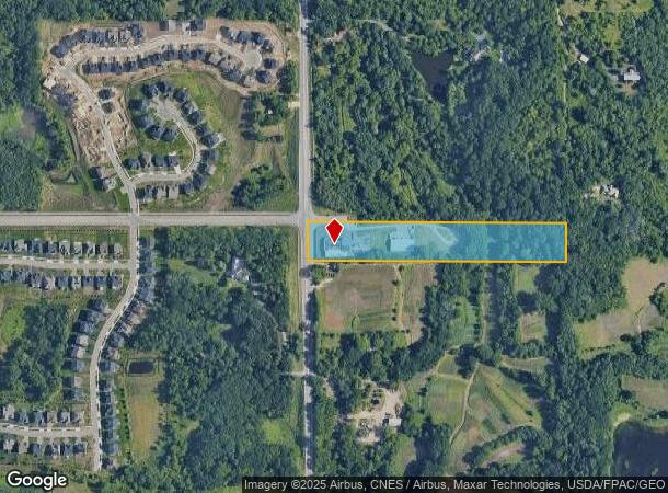
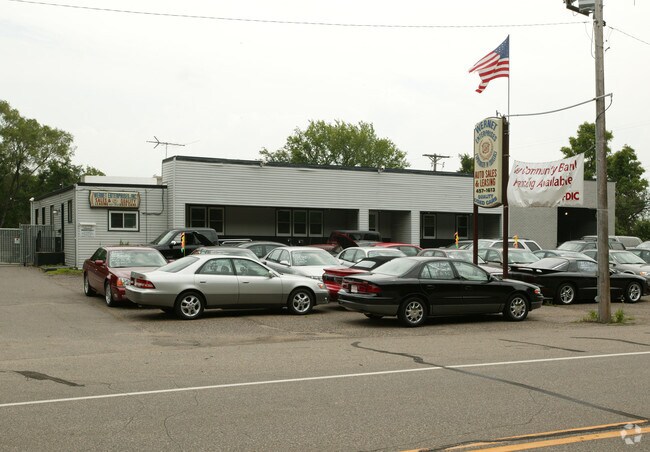
Property Record
6520 S Robert Trl, Inver Grove Heights, MN 55077

NEARBY LISTINGS FOR SALE OR LEASE
Property Detail
6520 S Robert Trl
20-00500-50-010
SECTION 5 TWN 27 RANGE 22 5 27 22 N 198 FT OF N 1/2 OF W 1/2 OF SW 1/4 SUBJ TO HGWY ESMNT OVER W 70 FT
Industrialgeneral
Dakota
X
Minnesota
27037C0105E
10
2024
5.96 AC
2024
South Central
060505
Minneapolis/St Paul
19,030 SF
Minneapolis-St. Paul-Bloomington, MN-WI
DEMOGRAPHICS near 6520 S Robert Trl
1 Mile
3 Mile
5 Mile
2024 Total Population
2,313
50,012
138,060
2029 Population
2,470
51,157
141,109
Pop Growth 2024-2029
+ 6.79%
+ 2.29%
+ 2.21%
Average Age
39
41
40
2024 Total Households
749
20,345
56,100
HH Growth 2024-2029
+ 6.68%
+ 2.32%
+ 2.24%
Median Household Inc
$151,770
$82,681
$85,705
Avg Household Size
2.80
2.40
2.40
2024 Avg HH Vehicles
2.00
2.00
2.00
Median Home Value
$579,019
$318,481
$320,170
Median Year Built
2010
1983
1981
Nearby Places
Map Layers
Map Styles
 Street
 Aerial
- Restaurants
- Banks
- Shops
- Fitness
- Groceries
PUBLIC TRANSPORTATION
COMMUTER RAIL
DRIVE
WALK
Distance
14 min
6.7 mi
AIRPORT
Minneapolis-St Paul International/Wold-Chamberlain
DRIVE
WALK
Distance
Minneapolis-St Paul International/Wold-Chamberlain
16 min
9.8 mi
Nearby Properties
Address
Land Use
TOTAL SIZE
Lot Size
Zoning
Address
Land Use
TOTAL SIZE
Lot Size
Zoning
479,742 SF
11.35 AC
Address
Land Use
TOTAL SIZE
Lot Size
Zoning
Address
Land Use
TOTAL SIZE
Lot Size
Zoning
146,085 SF
46.83 AC
Address
Land Use
TOTAL SIZE
Lot Size
Zoning
247,470 SF
2.21 AC
Address
Land Use
TOTAL SIZE
Lot Size
Zoning
293,970 SF
31.92 AC
Address
Land Use
TOTAL SIZE
Lot Size
Zoning
223,583 SF
5.32 AC
Address
Land Use
TOTAL SIZE
Lot Size
Zoning
381,158 SF
11.86 AC
Address
Land Use
TOTAL SIZE
Lot Size
Zoning
317,235 SF
32.38 AC
Address
Land Use
TOTAL SIZE
Lot Size
Zoning
300,000 SF
18.44 AC
Address
Land Use
TOTAL SIZE
Lot Size
Zoning
605,774 SF
44.50 AC
Address
Land Use
TOTAL SIZE
Lot Size
Zoning
228,810 SF
6.30 AC
Address
Land Use
TOTAL SIZE
Lot Size
Zoning
245,570 SF
2.85 AC
Address
Land Use
TOTAL SIZE
Lot Size
Zoning
Address
Land Use
TOTAL SIZE
Lot Size
Zoning
212,331 SF
9.27 AC
Address
Land Use
TOTAL SIZE
Lot Size
Zoning
163,985 SF
7.06 AC
Address
Land Use
TOTAL SIZE
Lot Size
Zoning
1,339,582 SF
78.22 AC
Address
Land Use
TOTAL SIZE
Lot Size
Zoning
541,075 SF
88.93 AC
Address
Land Use
TOTAL SIZE
Lot Size
Zoning
293,717 SF
33.30 AC
Address
Land Use
TOTAL SIZE
Lot Size
Zoning
206,503 SF
5.61 AC
Address
Land Use
TOTAL SIZE
Lot Size
Zoning
482,008 SF
23.78 AC
Address
Land Use
TOTAL SIZE
Lot Size
Zoning
229,442 SF
9.50 AC
Address
Land Use
TOTAL SIZE
Lot Size
Zoning
227,200 SF
14.78 AC
Address
Land Use
TOTAL SIZE
Lot Size
Zoning
237,170 SF
7.90 AC
Address
Land Use
TOTAL SIZE
Lot Size
Zoning
532,778 SF
4.99 AC
Address
Land Use
TOTAL SIZE
Lot Size
Zoning
221,019 SF
37.17 AC
Address
Land Use
TOTAL SIZE
Lot Size
Zoning
217,832 SF
15.13 AC
Address
Land Use
TOTAL SIZE
Lot Size
Zoning
138,609 SF
3.76 AC
Address
Land Use
TOTAL SIZE
Lot Size
Zoning
78,700 SF
6.12 AC
Address
Land Use
TOTAL SIZE
Lot Size
Zoning
160,669 SF
5.10 AC
The World's #1 Commercial Real Estate Marketplace
Connect with us
© 2025 CoStar Group
The information above has been obtained from sources believed reliable. While we do not doubt its accuracy we have not verified it and make no guarantee, warranty or representation about it. It is your responsibility to independently confirm its accuracy and completeness. Any projections, opinions, assumptions, or estimates used are for example only and do not represent the current or future performance of the property. The value of this transaction to you depends on tax and other factors which should be evaluated by your tax, financial, and legal advisors. You and your advisors should conduct a careful, independent investigation of the property to determine to your satisfaction the suitability of the property for your needs.