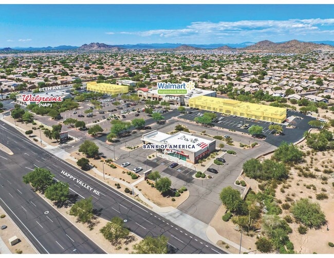
Property Record
6520 W Happy Valley Rd, Phoenix, AZ 85083


NEARBY LISTINGS FOR SALE OR LEASE
Property Detail
6520 W Happy Valley Rd
Phoenix-Mesa-Scottsdale, AZ
Happy Valley Center 2
201-35-074
HAPPY VALLEY CENTER 2 MCR 930-02
Regionalshoppingcenterormallwithanchorstore
Maricopa
X
Arizona
04013C1255L
3
2025
3.40 AC
2025
Surprise/North Peoria
611500
Phoenix
15,910 SF
DEMOGRAPHICS near 6520 W Happy Valley Rd
1 Mile
3 Mile
5 Mile
2024 Total Population
9,438
60,091
165,515
2029 Population
10,139
64,721
178,663
Pop Growth 2024-2029
+ 7.43%
+ 7.70%
+ 7.94%
Average Age
39
40
40
2024 Total Households
3,091
19,922
58,104
HH Growth 2024-2029
+ 7.44%
+ 7.73%
+ 8.04%
Median Household Inc
$148,802
$135,013
$110,401
Avg Household Size
3.00
2.90
2.80
2024 Avg HH Vehicles
3.00
2.00
2.00
Median Home Value
$466,592
$505,665
$441,676
Median Year Built
2000
2000
1997
Nearby Places
Map Layers
Map Styles
 Street
 Aerial
- Restaurants
- Banks
- Shops
- Fitness
- Groceries
PUBLIC TRANSPORTATION
AIRPORT
Phoenix Sky Harbor International
DRIVE
WALK
Distance
Phoenix Sky Harbor International
45 min
30.5 mi
SALE & LEASE HISTORY
LISTING DATE
SALE/LEASE

Jul 28, 2017
For Lease
Nearby Properties
Address
Land Use
TOTAL SIZE
Lot Size
Zoning
Address
Land Use
TOTAL SIZE
Lot Size
Zoning
239,750 SF
85.34 AC
SR43
Address
Land Use
TOTAL SIZE
Lot Size
Zoning
4,500 SF
13.50 AC
PAD
Address
Land Use
TOTAL SIZE
Lot Size
Zoning
291,137 SF
38.49 AC
AG
Address
Land Use
TOTAL SIZE
Lot Size
Zoning
89,875 SF
72.52 AC
R-43AG
Address
Land Use
TOTAL SIZE
Lot Size
Zoning
103,384 SF
15.25 AC
PAD
Address
Land Use
TOTAL SIZE
Lot Size
Zoning
127,100 SF
3.57 AC
PAD
Address
Land Use
TOTAL SIZE
Lot Size
Zoning
96,016 SF
4.47 AC
PAD
Address
Land Use
TOTAL SIZE
Lot Size
Zoning
102,816 SF
35.12 AC
AG
Address
Land Use
TOTAL SIZE
Lot Size
Zoning
88,542 SF
14.50 AC
R-10
Address
Land Use
TOTAL SIZE
Lot Size
Zoning
84,341 SF
14.58 AC
R-43
Address
Land Use
TOTAL SIZE
Lot Size
Zoning
72,097 SF
13.72 AC
R-43AG
Address
Land Use
TOTAL SIZE
Lot Size
Zoning
73,662 SF
13.70 AC
R-6
Address
Land Use
TOTAL SIZE
Lot Size
Zoning
78,822 SF
8.14 AC
AG
Address
Land Use
TOTAL SIZE
Lot Size
Zoning
73,694 SF
11.09 AC
R-6
Address
Land Use
TOTAL SIZE
Lot Size
Zoning
128,321 SF
6.69 AC
PAD
Address
Land Use
TOTAL SIZE
Lot Size
Zoning
249,001 SF
5.86 AC
M-M
Address
Land Use
TOTAL SIZE
Lot Size
Zoning
57,952 SF
5.19 AC
R-35
Address
Land Use
TOTAL SIZE
Lot Size
Zoning
73,841 SF
14.13 AC
R-43AG
Address
Land Use
TOTAL SIZE
Lot Size
Zoning
55,305 SF
5.78 AC
PAD
Address
Land Use
TOTAL SIZE
Lot Size
Zoning
61,713 SF
5.88 AC
C-C
Address
Land Use
TOTAL SIZE
Lot Size
Zoning
81,896 SF
9.95 AC
PAD
Address
Land Use
TOTAL SIZE
Lot Size
Zoning
59,760 SF
5.17 AC
PAD
Address
Land Use
TOTAL SIZE
Lot Size
Zoning
25,950 SF
37.51 AC
S-1
Address
Land Use
TOTAL SIZE
Lot Size
Zoning
130,241 SF
5.11 AC
SU
Address
Land Use
TOTAL SIZE
Lot Size
Zoning
57,428 SF
5.38 AC
C-R
Address
Land Use
TOTAL SIZE
Lot Size
Zoning
21,784 SF
6.70 AC
R-18
Address
Land Use
TOTAL SIZE
Lot Size
Zoning
39,729 SF
5.50 AC
C-C
Address
Land Use
TOTAL SIZE
Lot Size
Zoning
67,277 SF
6.54 AC
PAD
Address
Land Use
TOTAL SIZE
Lot Size
Zoning
24,200 SF
4.12 AC
C-C
The World's #1 Commercial Real Estate Marketplace
Connect with us
© 2025 CoStar Group
The information above has been obtained from sources believed reliable. While we do not doubt its accuracy we have not verified it and make no guarantee, warranty or representation about it. It is your responsibility to independently confirm its accuracy and completeness. Any projections, opinions, assumptions, or estimates used are for example only and do not represent the current or future performance of the property. The value of this transaction to you depends on tax and other factors which should be evaluated by your tax, financial, and legal advisors. You and your advisors should conduct a careful, independent investigation of the property to determine to your satisfaction the suitability of the property for your needs.