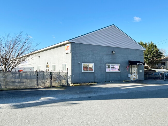
Property Record
6521 Governor Printz Blvd, Wilmington, DE 19809
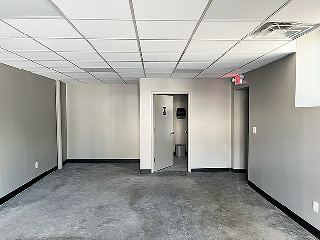
Current Lease Availabilities
NEARBY LISTINGS FOR SALE OR LEASE
Property Detail
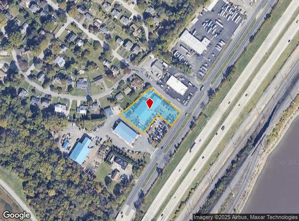
6521 Governor Printz Blvd
Philadelphia-Camden-Wilmington, PA-NJ-DE-MD
Delaire
06-125.00-029
LG 4 5.0830 AC .2403 AC
Autorepair
New Castle
A
Delaware
10003C0088L
3
2024
1.15 AC
2024
Wilmington
010502
Philadelphia
12,150 SF
DEMOGRAPHICS near 6521 Governor Printz Blvd
1 Mile
3 Mile
5 Mile
2024 Total Population
5,328
55,597
170,472
2029 Population
5,356
56,056
172,828
Pop Growth 2024-2029
+ 0.53%
+ 0.83%
+ 1.38%
Average Age
43
43
42
2024 Total Households
2,322
23,143
70,842
HH Growth 2024-2029
+ 0.34%
+ 0.83%
+ 1.46%
Median Household Inc
$91,864
$77,750
$69,573
Avg Household Size
2.20
2.30
2.30
2024 Avg HH Vehicles
2.00
2.00
2.00
Median Home Value
$299,329
$303,921
$307,775
Median Year Built
1956
1959
1959
Nearby Places
Map Layers
Map Styles
 Street
 Aerial
- Restaurants
- Banks
- Shops
- Fitness
- Groceries
PUBLIC TRANSPORTATION
COMMUTER RAIL
DRIVE
WALK
Distance
7 min
3.3 mi
Claymont (R2 - Southeastern Pennsylvania Transportation Authority Regional Rail (SEPTA Regional Rail))
DRIVE
WALK
Distance
Claymont (R2 - Southeastern Pennsylvania Transportation Authority Regional Rail (SEPTA Regional Rail))
8 min
3.4 mi
AIRPORT
Philadelphia International
DRIVE
WALK
Distance
Philadelphia International
26 min
16.3 mi
Freight Ports
Port of Wilmington, RI
DRIVE
WALK
Distance
Port of Wilmington, RI
12 min
6.6 mi
Nearby Properties
Address
Land Use
TOTAL SIZE
Lot Size
Zoning
Address
Land Use
TOTAL SIZE
Lot Size
Zoning
291,946 SF
21.27 AC
26R-2
Address
Land Use
TOTAL SIZE
Lot Size
Zoning
105.88 AC
26M-2
Address
Land Use
TOTAL SIZE
Lot Size
Zoning
109,145 SF
10.57 AC
S
Address
Land Use
TOTAL SIZE
Lot Size
Zoning
205,529 SF
42.34 AC
S
Address
Land Use
TOTAL SIZE
Lot Size
Zoning
20 AC
GI
Address
Land Use
TOTAL SIZE
Lot Size
Zoning
197,332 SF
12.13 AC
S
Address
Land Use
TOTAL SIZE
Lot Size
Zoning
231,920 SF
23.52 AC
S
Address
Land Use
TOTAL SIZE
Lot Size
Zoning
212,522 SF
16.04 AC
OR
Address
Land Use
TOTAL SIZE
Lot Size
Zoning
Address
Land Use
TOTAL SIZE
Lot Size
Zoning
204.56 AC
GI
Address
Land Use
TOTAL SIZE
Lot Size
Zoning
240,690 SF
18.44 AC
NCAP
Address
Land Use
TOTAL SIZE
Lot Size
Zoning
16,002 SF
16.91 AC
CR
Address
Land Use
TOTAL SIZE
Lot Size
Zoning
132,400 SF
7.79 AC
OR
Address
Land Use
TOTAL SIZE
Lot Size
Zoning
244,483 SF
10.01 AC
OR
Address
Land Use
TOTAL SIZE
Lot Size
Zoning
111,655 SF
50.62 AC
OR
Address
Land Use
TOTAL SIZE
Lot Size
Zoning
141,066 SF
36.52 AC
S
Address
Land Use
TOTAL SIZE
Lot Size
Zoning
359,520 SF
28.18 AC
HI
Address
Land Use
TOTAL SIZE
Lot Size
Zoning
180,096 SF
10.62 AC
ON
Address
Land Use
TOTAL SIZE
Lot Size
Zoning
324,733 SF
17.70 AC
NCAP
Address
Land Use
TOTAL SIZE
Lot Size
Zoning
212,990 SF
13.69 AC
S
Address
Land Use
TOTAL SIZE
Lot Size
Zoning
393,718 SF
42.16 AC
NCGA
Address
Land Use
TOTAL SIZE
Lot Size
Zoning
105,735 SF
113.29 AC
HI
Address
Land Use
TOTAL SIZE
Lot Size
Zoning
99,418 SF
7.17 AC
OR
Address
Land Use
TOTAL SIZE
Lot Size
Zoning
32.12 AC
Address
Land Use
TOTAL SIZE
Lot Size
Zoning
128,737 SF
5.44 AC
CR
Address
Land Use
TOTAL SIZE
Lot Size
Zoning
88,386 SF
3.77 AC
26R-2
Address
Land Use
TOTAL SIZE
Lot Size
Zoning
86,916 SF
24.70 AC
S
Address
Land Use
TOTAL SIZE
Lot Size
Zoning
71,400 SF
3.65 AC
OR
Address
Land Use
TOTAL SIZE
Lot Size
Zoning
72,024 SF
24.55 AC
S
Address
Land Use
TOTAL SIZE
Lot Size
Zoning
15,872 SF
10.25 AC
26C-2
The World's #1 Commercial Real Estate Marketplace
Connect with us
© 2025 CoStar Group
The information above has been obtained from sources believed reliable. While we do not doubt its accuracy we have not verified it and make no guarantee, warranty or representation about it. It is your responsibility to independently confirm its accuracy and completeness. Any projections, opinions, assumptions, or estimates used are for example only and do not represent the current or future performance of the property. The value of this transaction to you depends on tax and other factors which should be evaluated by your tax, financial, and legal advisors. You and your advisors should conduct a careful, independent investigation of the property to determine to your satisfaction the suitability of the property for your needs.