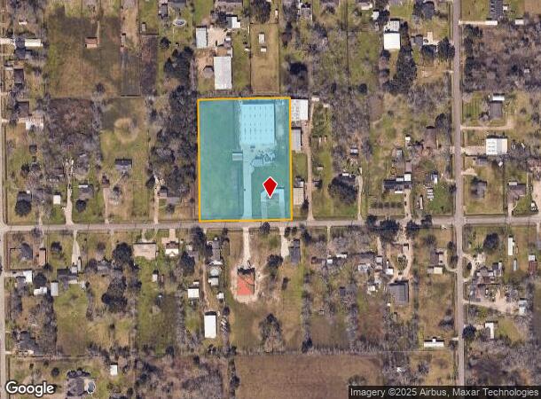
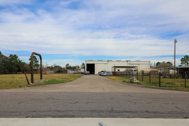
Property Record
6521 Amie Ln, Pearland, TX 77584


NEARBY LISTINGS FOR SALE OR LEASE
Property Detail
6521 Amie Ln
0245-0104-110
H T & B R R
Commercialnec
A0245 H T & B R R TRACT 24A-24A1-34A-34A1 ACRES 4.0023
AE
Brazoria
48039C0043K
Texas
2024
2 AC
2025
South Hwy 35
660902
Houston
21,594 SF
Houston-The Woodlands-Sugar Land, TX
DEMOGRAPHICS near 6521 Amie Ln
1 Mile
3 Mile
5 Mile
2024 Total Population
4,725
40,573
113,230
2029 Population
5,197
44,846
124,878
Pop Growth 2024-2029
+ 9.99%
+ 10.53%
+ 10.29%
Average Age
37
36
37
2024 Total Households
1,543
13,372
37,738
HH Growth 2024-2029
+ 10.17%
+ 10.69%
+ 10.40%
Median Household Inc
$99,887
$94,418
$107,390
Avg Household Size
3.00
3.00
2.90
2024 Avg HH Vehicles
2.00
2.00
2.00
Median Home Value
$287,054
$273,042
$299,661
Median Year Built
1999
1998
1999
Nearby Places
Map Layers
Map Styles
 Street
 Aerial
- Restaurants
- Banks
- Shops
- Fitness
- Groceries
PUBLIC TRANSPORTATION
AIRPORT
William P Hobby
DRIVE
WALK
Distance
William P Hobby
23 min
9.7 mi
Freight Ports
Port of Houston
DRIVE
WALK
Distance
Port of Houston
34 min
17.9 mi
SALE & LEASE HISTORY
LISTING DATE
SALE/LEASE

Sep 23, 2016
For Sale
May 14, 2021
For Sale
Mar 20, 2017
For Lease
Jan 18, 2022
For Sale
Nearby Properties
Address
Land Use
TOTAL SIZE
Lot Size
Zoning
Address
Land Use
TOTAL SIZE
Lot Size
Zoning
83.37 AC
0004
Address
Land Use
TOTAL SIZE
Lot Size
Zoning
64.56 AC
0016
Address
Land Use
TOTAL SIZE
Lot Size
Zoning
7.42 AC
Address
Land Use
TOTAL SIZE
Lot Size
Zoning
252,472 SF
13.28 AC
Address
Land Use
TOTAL SIZE
Lot Size
Zoning
79.45 AC
1000
Address
Land Use
TOTAL SIZE
Lot Size
Zoning
344,782 SF
14.14 AC
Address
Land Use
TOTAL SIZE
Lot Size
Zoning
113,376 SF
9.80 AC
Address
Land Use
TOTAL SIZE
Lot Size
Zoning
106,341 SF
12.12 AC
0550
Address
Land Use
TOTAL SIZE
Lot Size
Zoning
49.29 AC
0007
Address
Land Use
TOTAL SIZE
Lot Size
Zoning
19.61 AC
Address
Land Use
TOTAL SIZE
Lot Size
Zoning
95,592 SF
5.93 AC
Address
Land Use
TOTAL SIZE
Lot Size
Zoning
122,473 SF
2.30 AC
Address
Land Use
TOTAL SIZE
Lot Size
Zoning
55,751 SF
5.04 AC
Address
Land Use
TOTAL SIZE
Lot Size
Zoning
28,143 SF
13.08 AC
Address
Land Use
TOTAL SIZE
Lot Size
Zoning
3,159 SF
64.95 AC
0227
Address
Land Use
TOTAL SIZE
Lot Size
Zoning
57,558 SF
3.96 AC
0061
Address
Land Use
TOTAL SIZE
Lot Size
Zoning
67,000 SF
28.97 AC
Address
Land Use
TOTAL SIZE
Lot Size
Zoning
Address
Land Use
TOTAL SIZE
Lot Size
Zoning
67,130 SF
17.70 AC
0151
Address
Land Use
TOTAL SIZE
Lot Size
Zoning
9.72 AC
Address
Land Use
TOTAL SIZE
Lot Size
Zoning
84,254 SF
5.45 AC
Address
Land Use
TOTAL SIZE
Lot Size
Zoning
86,246 SF
5 AC
Address
Land Use
TOTAL SIZE
Lot Size
Zoning
27,648 SF
3.23 AC
0009
Address
Land Use
TOTAL SIZE
Lot Size
Zoning
32,596 SF
22.44 AC
1010
Address
Land Use
TOTAL SIZE
Lot Size
Zoning
26,586 SF
4.81 AC
0001
Address
Land Use
TOTAL SIZE
Lot Size
Zoning
4,290 SF
38.48 AC
Address
Land Use
TOTAL SIZE
Lot Size
Zoning
43,816 SF
1.86 AC
Address
Land Use
TOTAL SIZE
Lot Size
Zoning
55,826 SF
2.79 AC
Address
Land Use
TOTAL SIZE
Lot Size
Zoning
153,736 SF
9.25 AC
Address
Land Use
TOTAL SIZE
Lot Size
Zoning
21,637 SF
2 AC
0028
The World's #1 Commercial Real Estate Marketplace
Connect with us
© 2025 CoStar Group
The information above has been obtained from sources believed reliable. While we do not doubt its accuracy we have not verified it and make no guarantee, warranty or representation about it. It is your responsibility to independently confirm its accuracy and completeness. Any projections, opinions, assumptions, or estimates used are for example only and do not represent the current or future performance of the property. The value of this transaction to you depends on tax and other factors which should be evaluated by your tax, financial, and legal advisors. You and your advisors should conduct a careful, independent investigation of the property to determine to your satisfaction the suitability of the property for your needs.