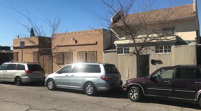
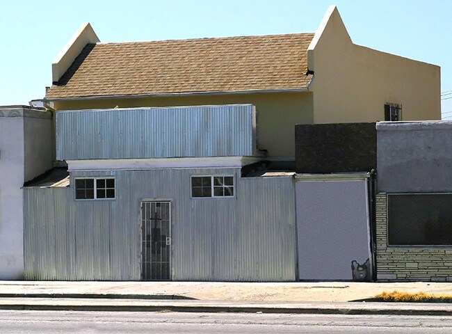
Property Record
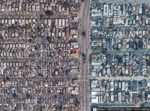
6521 S Vermont Ave, Los Angeles, CA 90044

NEARBY LISTINGS FOR SALE OR LEASE
Property Detail
6521 S Vermont Ave
Los Angeles-Long Beach-Glendale, CA
4388
6014-005-006
TRACT # 4388 LOT 4
Commercialofficeresidentialmixeduse
Los Angeles
X
California
06037C1781G
4
2024
0.12 AC
2025
Inglewood/South LA
237401
Los Angeles
3,757 SF
DEMOGRAPHICS near 6521 S Vermont Ave
1 Mile
3 Mile
5 Mile
2024 Total Population
56,389
447,700
1,062,023
2029 Population
54,237
428,926
1,021,866
Pop Growth 2024-2029
(3.82%)
(4.19%)
(3.78%)
Average Age
36
36
37
2024 Total Households
15,112
123,030
319,455
HH Growth 2024-2029
(4.08%)
(4.44%)
(3.79%)
Median Household Inc
$49,245
$50,988
$52,651
Avg Household Size
3.50
3.40
3.10
2024 Avg HH Vehicles
2.00
2.00
2.00
Median Home Value
$568,822
$631,777
$675,324
Median Year Built
1948
1948
1953
Nearby Places
Map Layers
Map Styles
 Street
 Aerial
- Restaurants
- Banks
- Shops
- Fitness
- Groceries
PUBLIC TRANSPORTATION
COMMUTER RAIL
DRIVE
WALK
Distance
13 min
8.0 mi
Union Station (91 Line - Southern California Regional Rail Authority (Metrolink), Antelope Valley Line - Southern California Regional Rail Authority (Metrolink), Orange County Line - Southern California Regional Rail Authority (Metrolink), Riverside Line - Southern California Regional Rail Authority (Metrolink), San Bernardino Line - Southern California Regional Rail Authority (Metrolink), Ventura County Line - Southern California Regional Rail Authority (Metrolink))
DRIVE
WALK
Distance
Union Station (91 Line - Southern California Regional Rail Authority (Metrolink), Antelope Valley Line - Southern California Regional Rail Authority (Metrolink), Orange County Line - Southern California Regional Rail Authority (Metrolink), Riverside Line - Southern California Regional Rail Authority (Metrolink), San Bernardino Line - Southern California Regional Rail Authority (Metrolink), Ventura County Line - Southern California Regional Rail Authority (Metrolink))
15 min
8.2 mi
AIRPORT
Los Angeles International
DRIVE
WALK
Distance
Los Angeles International
16 min
8.3 mi
Long Beach (Daugherty Field)
DRIVE
WALK
Distance
Long Beach (Daugherty Field)
25 min
17.8 mi
Bob Hope
DRIVE
WALK
Distance
Bob Hope
32 min
23.2 mi
Freight Ports
Port of Long Beach
DRIVE
WALK
Distance
Port of Long Beach
28 min
19.7 mi
SALE & LEASE HISTORY
LISTING DATE
SALE/LEASE

Nov 12, 2019
For Sale
Feb 27, 2019
For Lease
Nearby Properties
Address
Land Use
TOTAL SIZE
Lot Size
Zoning
Address
Land Use
TOTAL SIZE
Lot Size
Zoning
2,531,696 SF
79.60 AC
INCR*
Address
Land Use
TOTAL SIZE
Lot Size
Zoning
420,864 SF
63.07 AC
LAUSC-1A
Address
Land Use
TOTAL SIZE
Lot Size
Zoning
256,059 SF
Address
Land Use
TOTAL SIZE
Lot Size
Zoning
337,025 SF
14.59 AC
LAUSC-1A
Address
Land Use
TOTAL SIZE
Lot Size
Zoning
298,630 SF
4.64 AC
LAUSC-1B
Address
Land Use
TOTAL SIZE
Lot Size
Zoning
377,946 SF
5.03 AC
LAUSC-1A
Address
Land Use
TOTAL SIZE
Lot Size
Zoning
188,146 SF
1.54 AC
LAUSC-1A
Address
Land Use
TOTAL SIZE
Lot Size
Zoning
95,639 SF
0.53 AC
LAC2
Address
Land Use
TOTAL SIZE
Lot Size
Zoning
116,827 SF
0.64 AC
LAC2
Address
Land Use
TOTAL SIZE
Lot Size
Zoning
57,488 SF
4.30 AC
LAPF
Address
Land Use
TOTAL SIZE
Lot Size
Zoning
564,529 SF
2.67 AC
LAUSC-1B
Address
Land Use
TOTAL SIZE
Lot Size
Zoning
150,790 SF
0.74 AC
LAC2
Address
Land Use
TOTAL SIZE
Lot Size
Zoning
261,502 SF
0.84 AC
LACM
Address
Land Use
TOTAL SIZE
Lot Size
Zoning
134,044 SF
1.90 AC
LAC2
Address
Land Use
TOTAL SIZE
Lot Size
Zoning
729,505 SF
8.74 AC
LAUSC-1A
Address
Land Use
TOTAL SIZE
Lot Size
Zoning
353,009 SF
3.97 AC
LAUSC-2
Address
Land Use
TOTAL SIZE
Lot Size
Zoning
81,735 SF
4.10 AC
LAR4
Address
Land Use
TOTAL SIZE
Lot Size
Zoning
905,884 SF
4.38 AC
LAUSC-2
Address
Land Use
TOTAL SIZE
Lot Size
Zoning
103,656 SF
6.98 AC
LCM1
Address
Land Use
TOTAL SIZE
Lot Size
Zoning
402,118 SF
9.39 AC
LAC2
Address
Land Use
TOTAL SIZE
Lot Size
Zoning
133,455 SF
1.04 AC
LAC2
Address
Land Use
TOTAL SIZE
Lot Size
Zoning
111,213 SF
12.04 AC
LAR4
Address
Land Use
TOTAL SIZE
Lot Size
Zoning
173,222 SF
0.96 AC
LAR3
Address
Land Use
TOTAL SIZE
Lot Size
Zoning
188,030 SF
3.09 AC
LAR5
Address
Land Use
TOTAL SIZE
Lot Size
Zoning
115,366 SF
0.85 AC
LAM1
Address
Land Use
TOTAL SIZE
Lot Size
Zoning
135,060 SF
Address
Land Use
TOTAL SIZE
Lot Size
Zoning
122,154 SF
2.81 AC
LAP
Address
Land Use
TOTAL SIZE
Lot Size
Zoning
Address
Land Use
TOTAL SIZE
Lot Size
Zoning
51,006 SF
0.50 AC
LAC2
Address
Land Use
TOTAL SIZE
Lot Size
Zoning
102,260 SF
16.84 AC
LAR4
The World's #1 Commercial Real Estate Marketplace
Connect with us
© 2025 CoStar Group
The information above has been obtained from sources believed reliable. While we do not doubt its accuracy we have not verified it and make no guarantee, warranty or representation about it. It is your responsibility to independently confirm its accuracy and completeness. Any projections, opinions, assumptions, or estimates used are for example only and do not represent the current or future performance of the property. The value of this transaction to you depends on tax and other factors which should be evaluated by your tax, financial, and legal advisors. You and your advisors should conduct a careful, independent investigation of the property to determine to your satisfaction the suitability of the property for your needs.