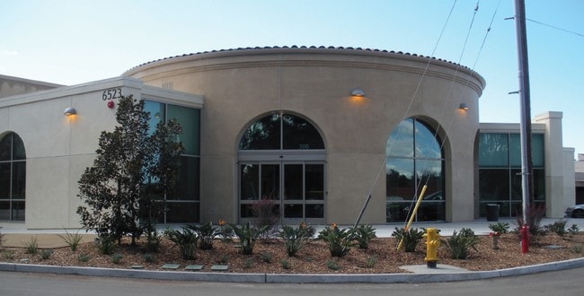
Property Record
6525 Helen Woodward Way, Solana Beach, CA 92075

NEARBY LISTINGS FOR SALE OR LEASE
Property Detail
6525 Helen Woodward Way
San Diego-Carlsbad, CA
Santa Fe Valley Lands
269-080-05
BLK Q LOT 11 ST CLSD ADJ&(EX RD)ALL N OF S LI BLK K MP 1742 IN TR 001924
Animalhospitalvet
San Diego
AE
California
06073C1327G
11
2024
5.62 AC
2025
Del Mar/S Bch/Rho SF
017307
San Diego
60,754 SF
DEMOGRAPHICS near 6525 Helen Woodward Way
1 Mile
3 Mile
5 Mile
2024 Total Population
1,352
31,411
153,917
2029 Population
1,284
30,840
152,176
Pop Growth 2024-2029
(5.03%)
(1.82%)
(1.13%)
Average Age
50
41
41
2024 Total Households
550
10,450
54,537
HH Growth 2024-2029
(5.45%)
(2.22%)
(1.20%)
Median Household Inc
$222,903
$210,276
$175,181
Avg Household Size
2.50
3.00
2.80
2024 Avg HH Vehicles
3.00
2.00
2.00
Median Home Value
$1,139,955
$1,136,475
$1,089,942
Median Year Built
1992
2002
1990
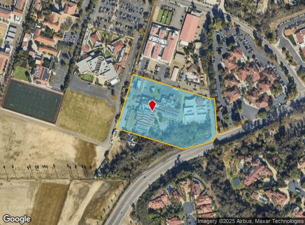
Nearby Places
Map Layers
Map Styles
 Street
 Aerial
- Restaurants
- Banks
- Shops
- Fitness
- Groceries
PUBLIC TRANSPORTATION
COMMUTER RAIL
Solana Beach (Coaster - San Diego North County Transit District (Coaster/Sprinter/Breeze))
DRIVE
WALK
Distance
Solana Beach (Coaster - San Diego North County Transit District (Coaster/Sprinter/Breeze))
13 min
5.9 mi
Sorrento Valley (Coaster - San Diego North County Transit District (Coaster/Sprinter/Breeze))
DRIVE
WALK
Distance
Sorrento Valley (Coaster - San Diego North County Transit District (Coaster/Sprinter/Breeze))
16 min
9.8 mi
AIRPORT
San Diego International
DRIVE
WALK
Distance
San Diego International
32 min
22.7 mi
Freight Ports
Port of San Diego
DRIVE
WALK
Distance
Port of San Diego
37 min
27.1 mi
Nearby Properties
Address
Land Use
TOTAL SIZE
Lot Size
Zoning
Address
Land Use
TOTAL SIZE
Lot Size
Zoning
3.67 AC
IP-2-1
Address
Land Use
TOTAL SIZE
Lot Size
Zoning
5.41 AC
IP-2-1
Address
Land Use
TOTAL SIZE
Lot Size
Zoning
14.16 AC
RM-1-3
Address
Land Use
TOTAL SIZE
Lot Size
Zoning
48.48 AC
RS-1-14
Address
Land Use
TOTAL SIZE
Lot Size
Zoning
5 AC
IP-2-1
Address
Land Use
TOTAL SIZE
Lot Size
Zoning
1.98 AC
CC-1-3
Address
Land Use
TOTAL SIZE
Lot Size
Zoning
46,415 SF
5.96 AC
S88
Address
Land Use
TOTAL SIZE
Lot Size
Zoning
8.78 AC
CVPD-SF2
Address
Land Use
TOTAL SIZE
Lot Size
Zoning
1.55 AC
CC-1-3
Address
Land Use
TOTAL SIZE
Lot Size
Zoning
56,591 SF
18.54 AC
S88
Address
Land Use
TOTAL SIZE
Lot Size
Zoning
59,754 SF
6.18 AC
C36
Address
Land Use
TOTAL SIZE
Lot Size
Zoning
14,598 SF
1.01 AC
C36
Address
Land Use
TOTAL SIZE
Lot Size
Zoning
69,484 SF
173.79 AC
A70
Address
Land Use
TOTAL SIZE
Lot Size
Zoning
49,792 SF
2.48 AC
RR
Address
Land Use
TOTAL SIZE
Lot Size
Zoning
71,469 SF
2.29 AC
AR-1-1
Address
Land Use
TOTAL SIZE
Lot Size
Zoning
9,700 SF
1.02 AC
S88
Address
Land Use
TOTAL SIZE
Lot Size
Zoning
82,555 SF
4.31 AC
C36
Address
Land Use
TOTAL SIZE
Lot Size
Zoning
3,628 SF
22.55 AC
RR
Address
Land Use
TOTAL SIZE
Lot Size
Zoning
4.89 AC
CVPD-SF1A
Address
Land Use
TOTAL SIZE
Lot Size
Zoning
37,004 SF
0.95 AC
CC-1-3
Address
Land Use
TOTAL SIZE
Lot Size
Zoning
40,565 SF
0.79 AC
CC-1-3
Address
Land Use
TOTAL SIZE
Lot Size
Zoning
97,797 SF
4.98 AC
RT-1-2
Address
Land Use
TOTAL SIZE
Lot Size
Zoning
98,397 SF
5.95 AC
RM-1-3
Address
Land Use
TOTAL SIZE
Lot Size
Zoning
37,517 SF
1.01 AC
CC-1-3
Address
Land Use
TOTAL SIZE
Lot Size
Zoning
39,878 SF
0.70 AC
CC-1-3
Address
Land Use
TOTAL SIZE
Lot Size
Zoning
6,306 SF
15 AC
A70
Address
Land Use
TOTAL SIZE
Lot Size
Zoning
5.98 AC
RX-1-1
Address
Land Use
TOTAL SIZE
Lot Size
Zoning
33,000 SF
372.75 AC
OF-1-1
Address
Land Use
TOTAL SIZE
Lot Size
Zoning
42,505 SF
1.69 AC
C30
The World's #1 Commercial Real Estate Marketplace
Connect with us
© 2026 CoStar Group
The information above has been obtained from sources believed reliable. While we do not doubt its accuracy we have not verified it and make no guarantee, warranty or representation about it. It is your responsibility to independently confirm its accuracy and completeness. Any projections, opinions, assumptions, or estimates used are for example only and do not represent the current or future performance of the property. The value of this transaction to you depends on tax and other factors which should be evaluated by your tax, financial, and legal advisors. You and your advisors should conduct a careful, independent investigation of the property to determine to your satisfaction the suitability of the property for your needs.