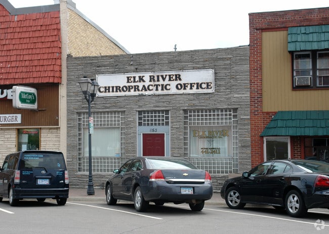
Property Record
653 Main St Nw, Elk River, MN 55330

NEARBY LISTINGS FOR SALE OR LEASE
Property Detail
653 Main St Nw
Minneapolis-St. Paul-Bloomington, MN-WI
Village (Elk River)
75-405-0420
E 25 FT OF W 59 FT OF LOT 1, BLK 4
Commercialofficeresidentialmixeduse
Sherburne
X
Minnesota
27003C0150E
1
2025
0.09 AC
2025
Sherburne County
030503
Minneapolis/St Paul
384 SF
DEMOGRAPHICS near 653 Main St Nw
1 Mile
3 Mile
5 Mile
2024 Total Population
4,954
31,022
48,218
2029 Population
5,423
34,192
53,104
Pop Growth 2024-2029
+ 9.47%
+ 10.22%
+ 10.13%
Average Age
39
38
38
2024 Total Households
2,139
11,167
16,939
HH Growth 2024-2029
+ 9.54%
+ 10.33%
+ 10.26%
Median Household Inc
$53,916
$91,922
$102,288
Avg Household Size
2.20
2.60
2.70
2024 Avg HH Vehicles
2.00
2.00
2.00
Median Home Value
$236,363
$281,121
$306,000
Median Year Built
1978
1994
1997
Nearby Places
Map Layers
Map Styles
 Street
 Aerial
- Restaurants
- Banks
- Shops
- Fitness
- Groceries
PUBLIC TRANSPORTATION
COMMUTER RAIL
Elk River Station (Northstar Corridor - Northstar Commuter Rail)
DRIVE
WALK
Distance
Elk River Station (Northstar Corridor - Northstar Commuter Rail)
5 min
2.4 mi
DRIVE
WALK
Distance
12 min
8.0 mi
AIRPORT
Minneapolis-St Paul International/Wold-Chamberlain
DRIVE
WALK
Distance
Minneapolis-St Paul International/Wold-Chamberlain
58 min
44.9 mi
SALE & LEASE HISTORY
LISTING DATE
SALE/LEASE

Dec 03, 2024
For Sale
Apr 16, 2025
For Sale
Nearby Properties
Address
Land Use
TOTAL SIZE
Lot Size
Zoning
Address
Land Use
TOTAL SIZE
Lot Size
Zoning
100,567 SF
32.13 AC
Address
Land Use
TOTAL SIZE
Lot Size
Zoning
245,262 SF
20.49 AC
Address
Land Use
TOTAL SIZE
Lot Size
Zoning
163,282 SF
5.25 AC
Address
Land Use
TOTAL SIZE
Lot Size
Zoning
88,188 SF
26.25 AC
Address
Land Use
TOTAL SIZE
Lot Size
Zoning
157,042 SF
24.60 AC
Address
Land Use
TOTAL SIZE
Lot Size
Zoning
3,000 SF
5.10 AC
Address
Land Use
TOTAL SIZE
Lot Size
Zoning
148,214 SF
8.73 AC
Address
Land Use
TOTAL SIZE
Lot Size
Zoning
23.48 AC
Address
Land Use
TOTAL SIZE
Lot Size
Zoning
103,080 SF
5.47 AC
Address
Land Use
TOTAL SIZE
Lot Size
Zoning
Address
Land Use
TOTAL SIZE
Lot Size
Zoning
139,077 SF
35.93 AC
Address
Land Use
TOTAL SIZE
Lot Size
Zoning
105,900 SF
26.26 AC
Address
Land Use
TOTAL SIZE
Lot Size
Zoning
Address
Land Use
TOTAL SIZE
Lot Size
Zoning
107,952 SF
3.52 AC
Address
Land Use
TOTAL SIZE
Lot Size
Zoning
114 SF
7.79 AC
Address
Land Use
TOTAL SIZE
Lot Size
Zoning
113 SF
8.08 AC
Address
Land Use
TOTAL SIZE
Lot Size
Zoning
113 SF
5.30 AC
Address
Land Use
TOTAL SIZE
Lot Size
Zoning
176,540 SF
14.08 AC
Address
Land Use
TOTAL SIZE
Lot Size
Zoning
84,491 SF
39.47 AC
Address
Land Use
TOTAL SIZE
Lot Size
Zoning
5,120 SF
4.91 AC
Address
Land Use
TOTAL SIZE
Lot Size
Zoning
59,941 SF
20.48 AC
Address
Land Use
TOTAL SIZE
Lot Size
Zoning
37,218 SF
3.41 AC
Address
Land Use
TOTAL SIZE
Lot Size
Zoning
90,810 SF
14.19 AC
Address
Land Use
TOTAL SIZE
Lot Size
Zoning
81,733 SF
8.89 AC
Address
Land Use
TOTAL SIZE
Lot Size
Zoning
3,000 SF
7.75 AC
Address
Land Use
TOTAL SIZE
Lot Size
Zoning
201,237 SF
21.20 AC
Address
Land Use
TOTAL SIZE
Lot Size
Zoning
85,493 SF
46.22 AC
Address
Land Use
TOTAL SIZE
Lot Size
Zoning
3.05 AC
Address
Land Use
TOTAL SIZE
Lot Size
Zoning
Address
Land Use
TOTAL SIZE
Lot Size
Zoning
The World's #1 Commercial Real Estate Marketplace
Connect with us
© 2026 CoStar Group
The information above has been obtained from sources believed reliable. While we do not doubt its accuracy we have not verified it and make no guarantee, warranty or representation about it. It is your responsibility to independently confirm its accuracy and completeness. Any projections, opinions, assumptions, or estimates used are for example only and do not represent the current or future performance of the property. The value of this transaction to you depends on tax and other factors which should be evaluated by your tax, financial, and legal advisors. You and your advisors should conduct a careful, independent investigation of the property to determine to your satisfaction the suitability of the property for your needs.