Property Record
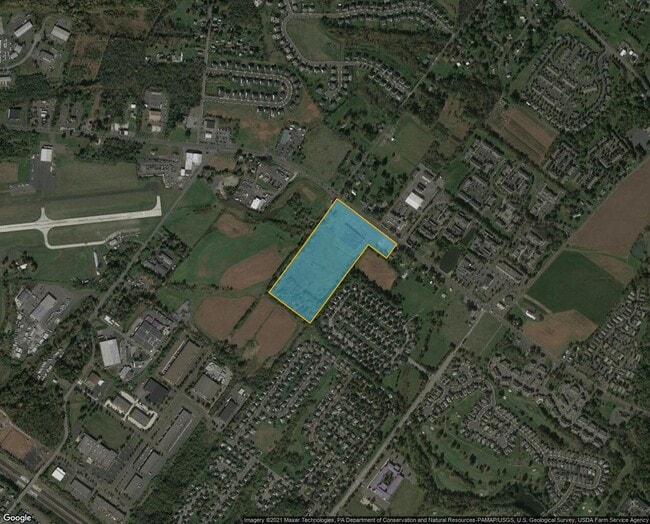
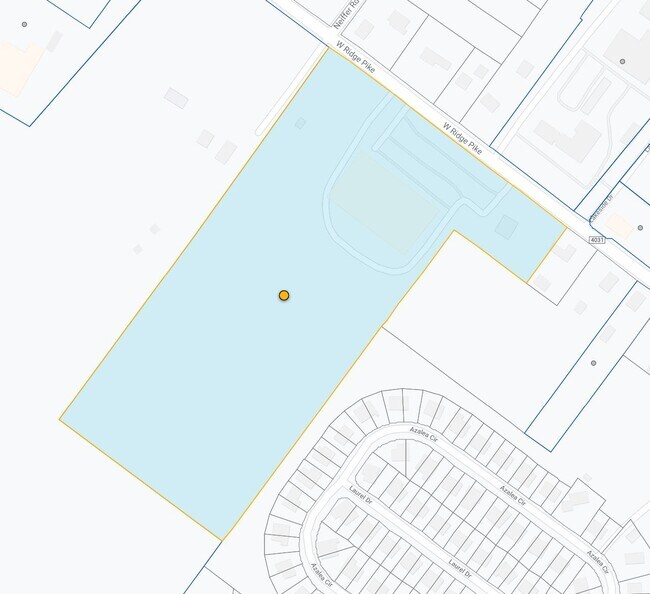
653 W Ridge Pike, Royersford, PA 19468

NEARBY LISTINGS FOR SALE OR LEASE
Property Detail
653 W Ridge Pike
Philadelphia-Camden-Wilmington, PA-NJ-DE-MD
Bowlero Limerick Llc
37-00-04051-007
911 X IRR 7.70 AC
Bowlingalley
Montgomery
X
Pennsylvania
42029C0025G
1
2024
7.70 AC
2025
West Montgomery County
208603
Philadelphia
50,298 SF
DEMOGRAPHICS near 653 W Ridge Pike
1 Mile
3 Mile
5 Mile
2024 Total Population
5,908
27,856
95,907
2029 Population
6,111
28,551
98,025
Pop Growth 2024-2029
+ 3.44%
+ 2.49%
+ 2.21%
Average Age
42
41
40
2024 Total Households
2,358
10,529
36,231
HH Growth 2024-2029
+ 3.60%
+ 2.59%
+ 2.27%
Median Household Inc
$104,430
$98,364
$98,429
Avg Household Size
2.50
2.60
2.60
2024 Avg HH Vehicles
2.00
2.00
2.00
Median Home Value
$324,038
$329,614
$310,650
Median Year Built
1998
1994
1985
Nearby Places
Map Layers
Map Styles
 Street
 Aerial
- Restaurants
- Banks
- Shops
- Fitness
- Groceries
PUBLIC TRANSPORTATION
AIRPORT
Lehigh Valley International
DRIVE
WALK
Distance
Lehigh Valley International
68 min
42.5 mi
Philadelphia International
DRIVE
WALK
Distance
Philadelphia International
66 min
43.0 mi
Freight Ports
Port of Philadelphia
DRIVE
WALK
Distance
Port of Philadelphia
61 min
35.9 mi
Nearby Properties
Address
Land Use
TOTAL SIZE
Lot Size
Zoning
Address
Land Use
TOTAL SIZE
Lot Size
Zoning
605,161 SF
78.08 AC
LLI
Address
Land Use
TOTAL SIZE
Lot Size
Zoning
1,298,806 SF
305.46 AC
HI
Address
Land Use
TOTAL SIZE
Lot Size
Zoning
268,366 SF
32.55 AC
R4
Address
Land Use
TOTAL SIZE
Lot Size
Zoning
271,556 SF
38.87 AC
R4
Address
Land Use
TOTAL SIZE
Lot Size
Zoning
316,623 SF
15.26 AC
R4
Address
Land Use
TOTAL SIZE
Lot Size
Zoning
233,630 SF
15 AC
R4
Address
Land Use
TOTAL SIZE
Lot Size
Zoning
185,077 SF
6.10 AC
MS
Address
Land Use
TOTAL SIZE
Lot Size
Zoning
125,788 SF
24.83 AC
R1
Address
Land Use
TOTAL SIZE
Lot Size
Zoning
152,928 SF
20.28 AC
R1
Address
Land Use
TOTAL SIZE
Lot Size
Zoning
103,819 SF
33 AC
R1
Address
Land Use
TOTAL SIZE
Lot Size
Zoning
124,079 SF
16.92 AC
MS
Address
Land Use
TOTAL SIZE
Lot Size
Zoning
97,188 SF
13.13 AC
OLI
Address
Land Use
TOTAL SIZE
Lot Size
Zoning
134,334 SF
21.95 AC
RB
Address
Land Use
TOTAL SIZE
Lot Size
Zoning
68,378 SF
27 AC
R3
Address
Land Use
TOTAL SIZE
Lot Size
Zoning
147,444 SF
16.09 AC
LLI
Address
Land Use
TOTAL SIZE
Lot Size
Zoning
82,802 SF
29.01 AC
R1
Address
Land Use
TOTAL SIZE
Lot Size
Zoning
98,208 SF
2.26 AC
CRSC
Address
Land Use
TOTAL SIZE
Lot Size
Zoning
214,914 SF
48.17 AC
OLI
Address
Land Use
TOTAL SIZE
Lot Size
Zoning
222,272 SF
21.60 AC
OLI
Address
Land Use
TOTAL SIZE
Lot Size
Zoning
83,186 SF
11.81 AC
CRSC
Address
Land Use
TOTAL SIZE
Lot Size
Zoning
74,270 SF
7.25 AC
MS
Address
Land Use
TOTAL SIZE
Lot Size
Zoning
245,651 SF
20.79 AC
R2
Address
Land Use
TOTAL SIZE
Lot Size
Zoning
68,775 SF
14.91 AC
OLI
Address
Land Use
TOTAL SIZE
Lot Size
Zoning
73,584 SF
0.74 AC
LI
Address
Land Use
TOTAL SIZE
Lot Size
Zoning
73,584 SF
0.64 AC
LI
Address
Land Use
TOTAL SIZE
Lot Size
Zoning
73,584 SF
0.72 AC
LI
Address
Land Use
TOTAL SIZE
Lot Size
Zoning
73,584 SF
0.68 AC
LI
Address
Land Use
TOTAL SIZE
Lot Size
Zoning
0.70 AC
LI
Address
Land Use
TOTAL SIZE
Lot Size
Zoning
115,054 SF
6.97 AC
R12
Address
Land Use
TOTAL SIZE
Lot Size
Zoning
70,315 SF
15.64 AC
R4
The World's #1 Commercial Real Estate Marketplace
Connect with us
© 2026 CoStar Group
The information above has been obtained from sources believed reliable. While we do not doubt its accuracy we have not verified it and make no guarantee, warranty or representation about it. It is your responsibility to independently confirm its accuracy and completeness. Any projections, opinions, assumptions, or estimates used are for example only and do not represent the current or future performance of the property. The value of this transaction to you depends on tax and other factors which should be evaluated by your tax, financial, and legal advisors. You and your advisors should conduct a careful, independent investigation of the property to determine to your satisfaction the suitability of the property for your needs.