Property Record
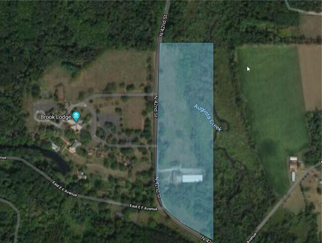
6530 N 42Nd St, Augusta, MI 49012

Property Detail
6530 N 42Nd St
04-27-155-010
SEC 27-1-9 COMM N 1/4 POST OF SEC TH S 00DEG-53'-17" E ALG THE N & S 1/4 LI OF SD SEC 1329.79 FT NW COR S1/2 NE1/4 TH N
Commercialnec
Kalamazoo
AG
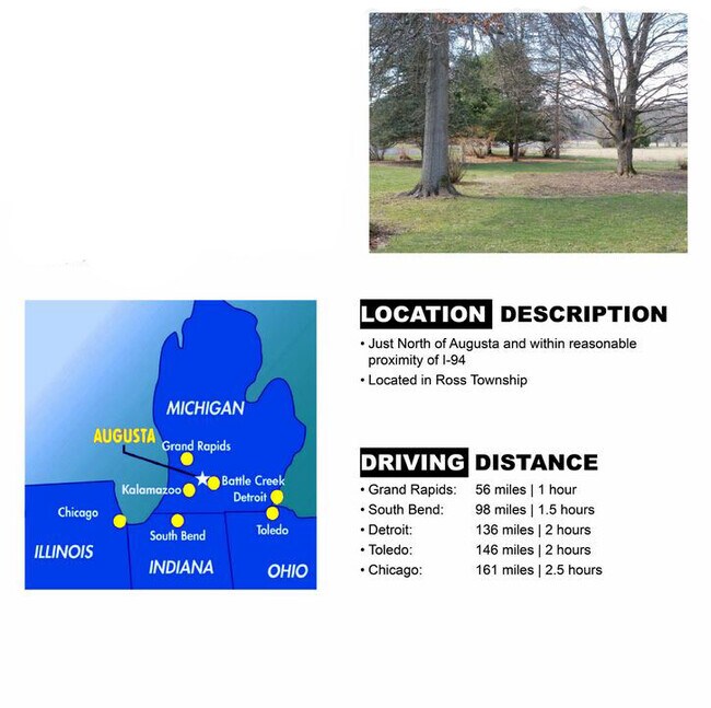
Michigan
A Areas with a 1% annual chance of flooding and a 26% chance of flooding over the life of a 30-year mortgage.
19.58 AC
0
NE Kalamazoo County
2025
West Michigan
002601
Kalamazoo-Portage, MI
1,685 SF
NEARBY LISTINGS FOR SALE OR LEASE
-
-
View all Augusta listings for sale on LoopNet.com
DEMOGRAPHICS near 6530 N 42Nd St
1 mile
3 mile
5 mile
2025 Total Population
100
3,719
13,417
2030 Population
99
3,780
13,718
Pop Growth 2025-2030
(1.00%)
+ 1.64%
+ 2.24%
Average Age
42
45
43
2025 Total Households
41
1,565
5,524
HH Growth 2025-2030
0.00%
+ 1.60%
+ 2.23%
Median Household Inc
$67,500
$91,346
$80,657
Avg Household Size
2.40
2.40
2.40
2025 Avg HH Vehicles
2.00
2.00
2.00
Median Home Value
$176,666
$334,025
$323,357
Median Year Built
1958
1969
1975
Nearby Places
Map Layers
Map Styles
 Street
 Aerial
Layers
 Traffic
 Biking
Places
Listings with unknown addresses are not visible on the map
- Restaurants
- Banks
- Shops
- Fitness
- Groceries
PUBLIC TRANSPORTATION
AIRPORT
Kalamazoo/Battle Creek International
Drive
Walk
Distance
Kalamazoo/Battle Creek International
30 min
17.0 mi
Freight Ports
Port of Toledo
Drive
Walk
Distance
Port of Toledo
166 min
134.6 mi
SALE & LEASE HISTORY
LISTING DATE
SALE/LEASE

Apr 02, 2020
For Sale
Nearby Properties
Address
Land Use
TOTAL SIZE
Lot Size
Zoning
Address
Land Use
TOTAL SIZE
Lot Size
Zoning
53,676 SF
22 AC
R-1
Address
Land Use
TOTAL SIZE
Lot Size
Zoning
44,920 SF
2.99 AC
C-1
Address
Land Use
TOTAL SIZE
Lot Size
Zoning
80,545 SF
9.29 AC
VILLAGE
Address
Land Use
TOTAL SIZE
Lot Size
Zoning
5,572 SF
5.24 AC
C-1
Address
Land Use
TOTAL SIZE
Lot Size
Zoning
13,269 SF
123.32 AC
C-1
Address
Land Use
TOTAL SIZE
Lot Size
Zoning
11,363 SF
137.70 AC
R-1
Address
Land Use
TOTAL SIZE
Lot Size
Zoning
1,596 SF
22.78 AC
AG
Address
Land Use
TOTAL SIZE
Lot Size
Zoning
Address
Land Use
TOTAL SIZE
Lot Size
Zoning
19,106 SF
155.30 AC
RR
Address
Land Use
TOTAL SIZE
Lot Size
Zoning
1,906 SF
77.61 AC
AG-2
Address
Land Use
TOTAL SIZE
Lot Size
Zoning
1,217 SF
0.22 AC
R-1
Address
Land Use
TOTAL SIZE
Lot Size
Zoning
Address
Land Use
TOTAL SIZE
Lot Size
Zoning
4,560 SF
1.53 AC
VILLAGE
Address
Land Use
TOTAL SIZE
Lot Size
Zoning
14,454 SF
1.51 AC
VILLAGE
Address
Land Use
TOTAL SIZE
Lot Size
Zoning
1,080 SF
108.20 AC
RR
Address
Land Use
TOTAL SIZE
Lot Size
Zoning
5,162 SF
0.53 AC
C-1
Address
Land Use
TOTAL SIZE
Lot Size
Zoning
21,492 SF
2.26 AC
VILLAGE
Address
Land Use
TOTAL SIZE
Lot Size
Zoning
1,914 SF
73.72 AC
RR
Address
Land Use
TOTAL SIZE
Lot Size
Zoning
192 SF
80 AC
RR
Address
Land Use
TOTAL SIZE
Lot Size
Zoning
12,607 SF
2.27 AC
C-1
Address
Land Use
TOTAL SIZE
Lot Size
Zoning
3,882 SF
24.41 AC
RR
Address
Land Use
TOTAL SIZE
Lot Size
Zoning
4,444 SF
0.24 AC
C-1
Address
Land Use
TOTAL SIZE
Lot Size
Zoning
53.51 AC
RR
Address
Land Use
TOTAL SIZE
Lot Size
Zoning
15,568 SF
0.19 AC
C-1
Address
Land Use
TOTAL SIZE
Lot Size
Zoning
0.36 AC
R-1
Address
Land Use
TOTAL SIZE
Lot Size
Zoning
2,056 SF
6.06 AC
RR
Address
Land Use
TOTAL SIZE
Lot Size
Zoning
40.62 AC
AG
Address
Land Use
TOTAL SIZE
Lot Size
Zoning
1,716 SF
78.67 AC
RR
Address
Land Use
TOTAL SIZE
Lot Size
Zoning
124.90 AC
R-1
The World's #1 Commercial Real Estate Marketplace
Connect with us
© 2026 CoStar Group
The information above has been obtained from sources believed reliable. While we do not doubt its accuracy we have not verified it and make no guarantee, warranty or representation about it. It is your responsibility to independently confirm its accuracy and completeness. Any projections, opinions, assumptions, or estimates used are for example only and do not represent the current or future performance of the property. The value of this transaction to you depends on tax and other factors which should be evaluated by your tax, financial, and legal advisors. You and your advisors should conduct a careful, independent investigation of the property to determine to your satisfaction the suitability of the property for your needs.