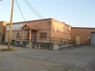
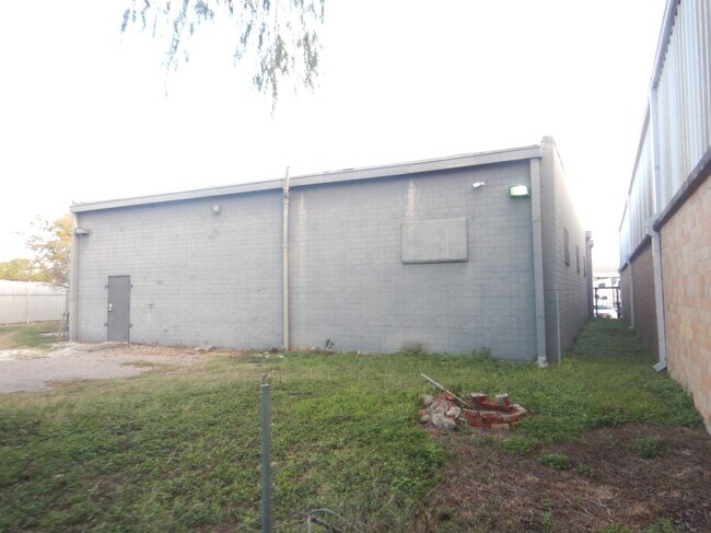
Property Record
6530 Supply Row, Houston, TX 77011
Current Lease Availabilities
NEARBY LISTINGS FOR SALE OR LEASE
Property Detail
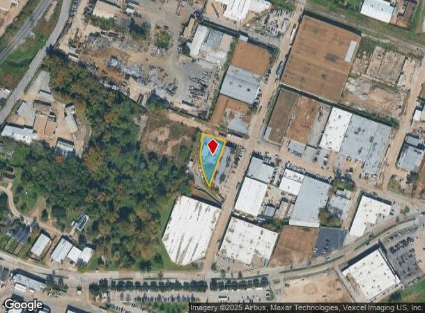
6530 Supply Row
0761650000005
Supply Row Center
Storebuilding
TR 5 SUPPLY ROW CENTER
X
Harris
48201C0885N
Texas
2024
0.39 AC
2025
Downtown Houston
310800
Houston
6,500 SF
Houston-Pasadena-The Woodlands, TX
DEMOGRAPHICS near 6530 Supply Row
1 mile
3 mile
5 mile
2024 Total Population
17,897
129,691
376,002
2029 Population
18,411
133,944
389,210
Pop Growth 2024-2029
+ 2.87%
+ 3.28%
+ 3.51%
Average Age
38
36
37
2024 Total Households
6,612
45,239
143,156
HH Growth 2024-2029
+ 2.86%
+ 3.55%
+ 3.90%
Median Household Inc
$35,817
$41,174
$48,508
Avg Household Size
2.60
2.50
2.40
2024 Avg HH Vehicles
2.00
2.00
2.00
Median Home Value
$256,859
$194,208
$190,823
Median Year Built
1951
1957
1968
Nearby Places
Map Layers
Map Styles
 Street
 Aerial
Transit
 Traffic
 Biking
Places
Listings with unknown addresses are not visible on the map
- Restaurants
- Banks
- Shops
- Fitness
- Groceries
PUBLIC TRANSPORTATION
TRANSIT/SUBWAY
Cesar Chavez / 67Th St Wb (METRORAIL GREEN LINE - Metropolitan Transit Authority of Harris County)
Drive
Walk
Distance
Cesar Chavez / 67Th St Wb (METRORAIL GREEN LINE - Metropolitan Transit Authority of Harris County)
1 min
7 min
0.4 mi
Cesar Chavez / 67Th St Eb (METRORAIL GREEN LINE - Metropolitan Transit Authority of Harris County)
Drive
Walk
Distance
Cesar Chavez / 67Th St Eb (METRORAIL GREEN LINE - Metropolitan Transit Authority of Harris County)
1 min
8 min
0.5 mi
Magnolia Park Transit Center Eb (METRORAIL GREEN LINE - Metropolitan Transit Authority of Harris County)
Drive
Walk
Distance
Magnolia Park Transit Center Eb (METRORAIL GREEN LINE - Metropolitan Transit Authority of Harris County)
2 min
13 min
0.7 mi
Magnolia Park Transit Center Wb (METRORAIL GREEN LINE - Metropolitan Transit Authority of Harris County)
Drive
Walk
Distance
Magnolia Park Transit Center Wb (METRORAIL GREEN LINE - Metropolitan Transit Authority of Harris County)
2 min
13 min
0.7 mi
Altic / Howard Hughes Eb (METRORAIL GREEN LINE - Metropolitan Transit Authority of Harris County, METRORAIL PURPLE LINE - Metropolitan Transit Authority of Harris County)
Drive
Walk
Distance
Altic / Howard Hughes Eb (METRORAIL GREEN LINE - Metropolitan Transit Authority of Harris County, METRORAIL PURPLE LINE - Metropolitan Transit Authority of Harris County)
2 min
18 min
0.9 mi
COMMUTER RAIL
Houston (Sunset Limited - Amtrak)
Drive
Walk
Distance
Houston (Sunset Limited - Amtrak)
11 min
6.1 mi
AIRPORT
William P Hobby
Drive
Walk
Distance
William P Hobby
19 min
9.0 mi
George Bush Intcntl/Houston
Drive
Walk
Distance
George Bush Intcntl/Houston
32 min
21.9 mi
Freight Ports
Port of Houston
Drive
Walk
Distance
Port of Houston
13 min
5.7 mi
Nearby Properties
Address
Land Use
TOTAL SIZE
Lot Size
Zoning
Address
Land Use
TOTAL SIZE
Lot Size
Zoning
1,392,720 SF
83.75 AC
Address
Land Use
TOTAL SIZE
Lot Size
Zoning
587,515 SF
4.85 AC
Address
Land Use
TOTAL SIZE
Lot Size
Zoning
453,987 SF
4.33 AC
Address
Land Use
TOTAL SIZE
Lot Size
Zoning
2,275,058 SF
24.47 AC
Address
Land Use
TOTAL SIZE
Lot Size
Zoning
403,242 SF
46.18 AC
Address
Land Use
TOTAL SIZE
Lot Size
Zoning
400,641 SF
1.86 AC
Address
Land Use
TOTAL SIZE
Lot Size
Zoning
406,772 SF
4.30 AC
Address
Land Use
TOTAL SIZE
Lot Size
Zoning
1,171,276 SF
44.19 AC
Address
Land Use
TOTAL SIZE
Lot Size
Zoning
463,768 SF
6.23 AC
Address
Land Use
TOTAL SIZE
Lot Size
Zoning
278,362 SF
1.70 AC
Address
Land Use
TOTAL SIZE
Lot Size
Zoning
159,235 SF
1.49 AC
Address
Land Use
TOTAL SIZE
Lot Size
Zoning
406,586 SF
4.03 AC
Address
Land Use
TOTAL SIZE
Lot Size
Zoning
242,936 SF
Address
Land Use
TOTAL SIZE
Lot Size
Zoning
329,500 SF
1.82 AC
Address
Land Use
TOTAL SIZE
Lot Size
Zoning
310,171 SF
2.35 AC
Address
Land Use
TOTAL SIZE
Lot Size
Zoning
17.84 AC
Address
Land Use
TOTAL SIZE
Lot Size
Zoning
186,460 SF
1.45 AC
Address
Land Use
TOTAL SIZE
Lot Size
Zoning
245,307 SF
1.67 AC
Address
Land Use
TOTAL SIZE
Lot Size
Zoning
198,023 SF
17.87 AC
Address
Land Use
TOTAL SIZE
Lot Size
Zoning
33.97 AC
Address
Land Use
TOTAL SIZE
Lot Size
Zoning
901,984 SF
59.37 AC
Address
Land Use
TOTAL SIZE
Lot Size
Zoning
504,018 SF
37.16 AC
Address
Land Use
TOTAL SIZE
Lot Size
Zoning
156,349 SF
1.44 AC
Address
Land Use
TOTAL SIZE
Lot Size
Zoning
923,370 SF
13.72 AC
Address
Land Use
TOTAL SIZE
Lot Size
Zoning
785,097 SF
27.77 AC
Address
Land Use
TOTAL SIZE
Lot Size
Zoning
111,415 SF
0.93 AC
Address
Land Use
TOTAL SIZE
Lot Size
Zoning
985,528 SF
22.64 AC
Address
Land Use
TOTAL SIZE
Lot Size
Zoning
923,370 SF
13.76 AC
Address
Land Use
TOTAL SIZE
Lot Size
Zoning
232,915 SF
7.89 AC
Address
Land Use
TOTAL SIZE
Lot Size
Zoning
228,886 SF
1.85 AC
The World's #1 Commercial Real Estate Marketplace
Connect with us
© 2026 CoStar Group
The information above has been obtained from sources believed reliable. While we do not doubt its accuracy we have not verified it and make no guarantee, warranty or representation about it. It is your responsibility to independently confirm its accuracy and completeness. Any projections, opinions, assumptions, or estimates used are for example only and do not represent the current or future performance of the property. The value of this transaction to you depends on tax and other factors which should be evaluated by your tax, financial, and legal advisors. You and your advisors should conduct a careful, independent investigation of the property to determine to your satisfaction the suitability of the property for your needs.