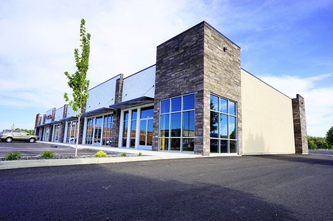
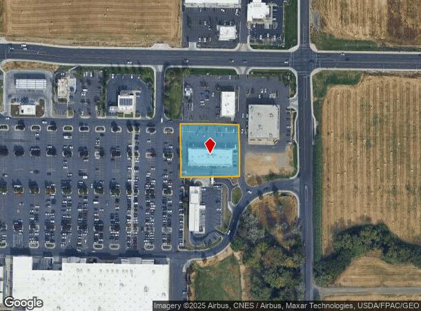
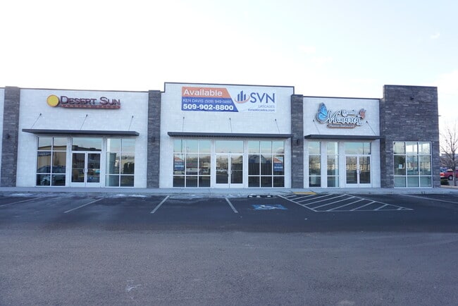
Property Record
6530 W Nob Hill Blvd, Yakima, WA 98908
NEARBY LISTINGS FOR SALE OR LEASE
Property Detail
6530 W Nob Hill Blvd
Yakima, WA
Sp 7765439
181329-41422
SECTION 29 TOWNSHIP 13 RANGE 18 QUARTER SE: SP 7765439 LOT 5
Storebuilding
Yakima
X
Washington
53077C1028F
5
2025
1.08 AC
2025
Outlying Yakima County
000902
Yakima
10,464 SF
DEMOGRAPHICS near 6530 W Nob Hill Blvd
1 Mile
3 Mile
5 Mile
2024 Total Population
10,244
56,041
108,883
2029 Population
10,567
56,747
109,653
Pop Growth 2024-2029
+ 3.15%
+ 1.26%
+ 0.71%
Average Age
39
41
38
2024 Total Households
4,111
22,173
40,069
HH Growth 2024-2029
+ 2.92%
+ 1.23%
+ 0.69%
Median Household Inc
$63,775
$68,285
$57,241
Avg Household Size
2.50
2.50
2.60
2024 Avg HH Vehicles
2.00
2.00
2.00
Median Home Value
$270,193
$289,946
$264,938
Median Year Built
1991
1977
1973
Nearby Places
Map Layers
Map Styles
 Street
 Aerial
- Restaurants
- Banks
- Shops
- Fitness
- Groceries
PUBLIC TRANSPORTATION
AIRPORT
Yakima Air Trml/McAllister Field
DRIVE
WALK
Distance
Yakima Air Trml/McAllister Field
8 min
3.4 mi
SALE & LEASE HISTORY
LISTING DATE
SALE/LEASE

Sep 25, 2016
For Lease
Feb 14, 2022
For Lease
Nearby Properties
Address
Land Use
TOTAL SIZE
Lot Size
Zoning
Address
Land Use
TOTAL SIZE
Lot Size
Zoning
331,736 SF
34.95 AC
R1
Address
Land Use
TOTAL SIZE
Lot Size
Zoning
409,453 SF
8.25 AC
R3
Address
Land Use
TOTAL SIZE
Lot Size
Zoning
275,342 SF
16.10 AC
R1
Address
Land Use
TOTAL SIZE
Lot Size
Zoning
226,069 SF
12.81 AC
C1
Address
Land Use
TOTAL SIZE
Lot Size
Zoning
205,680 SF
24.88 AC
C1
Address
Land Use
TOTAL SIZE
Lot Size
Zoning
119,023 SF
7.42 AC
R3
Address
Land Use
TOTAL SIZE
Lot Size
Zoning
69,675 SF
7.49 AC
R1
Address
Land Use
TOTAL SIZE
Lot Size
Zoning
65,606 SF
3.39 AC
R2
Address
Land Use
TOTAL SIZE
Lot Size
Zoning
114,192 SF
5.07 AC
C1
Address
Land Use
TOTAL SIZE
Lot Size
Zoning
69,675 SF
10.48 AC
R1
Address
Land Use
TOTAL SIZE
Lot Size
Zoning
107,078 SF
14.96 AC
R1
Address
Land Use
TOTAL SIZE
Lot Size
Zoning
132,213 SF
4 AC
R3
Address
Land Use
TOTAL SIZE
Lot Size
Zoning
162,216 SF
11 AC
M1
Address
Land Use
TOTAL SIZE
Lot Size
Zoning
57,009 SF
212.58 AC
AS
Address
Land Use
TOTAL SIZE
Lot Size
Zoning
130,114 SF
27.76 AC
R1
Address
Land Use
TOTAL SIZE
Lot Size
Zoning
105,756 SF
6.89 AC
R3
Address
Land Use
TOTAL SIZE
Lot Size
Zoning
93,286 SF
8.87 AC
R3
Address
Land Use
TOTAL SIZE
Lot Size
Zoning
162,933 SF
14.96 AC
SCC
Address
Land Use
TOTAL SIZE
Lot Size
Zoning
118,830 SF
5.34 AC
LCC
Address
Land Use
TOTAL SIZE
Lot Size
Zoning
86,547 SF
4.41 AC
R3
Address
Land Use
TOTAL SIZE
Lot Size
Zoning
89,850 SF
14.03 AC
R1
Address
Land Use
TOTAL SIZE
Lot Size
Zoning
65,968 SF
1.51 AC
R2
Address
Land Use
TOTAL SIZE
Lot Size
Zoning
83,430 SF
4.22 AC
SCC
Address
Land Use
TOTAL SIZE
Lot Size
Zoning
42,646 SF
4.54 AC
B1
Address
Land Use
TOTAL SIZE
Lot Size
Zoning
49,899 SF
1.22 AC
R3
Address
Land Use
TOTAL SIZE
Lot Size
Zoning
30,041 SF
4.12 AC
B2
Address
Land Use
TOTAL SIZE
Lot Size
Zoning
65,602 SF
10 AC
AS
Address
Land Use
TOTAL SIZE
Lot Size
Zoning
57,223 SF
2.98 AC
B1
Address
Land Use
TOTAL SIZE
Lot Size
Zoning
29,752 SF
2.17 AC
B1
Address
Land Use
TOTAL SIZE
Lot Size
Zoning
71,728 SF
2.96 AC
LCC
The World's #1 Commercial Real Estate Marketplace
Connect with us
© 2025 CoStar Group
The information above has been obtained from sources believed reliable. While we do not doubt its accuracy we have not verified it and make no guarantee, warranty or representation about it. It is your responsibility to independently confirm its accuracy and completeness. Any projections, opinions, assumptions, or estimates used are for example only and do not represent the current or future performance of the property. The value of this transaction to you depends on tax and other factors which should be evaluated by your tax, financial, and legal advisors. You and your advisors should conduct a careful, independent investigation of the property to determine to your satisfaction the suitability of the property for your needs.