Property Record
6531 103Rd St, Jacksonville, FL 32210
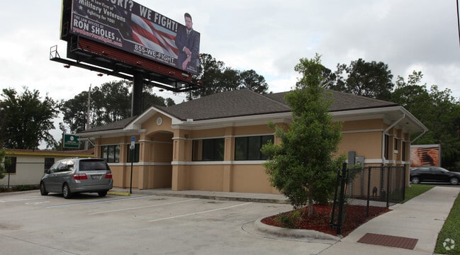

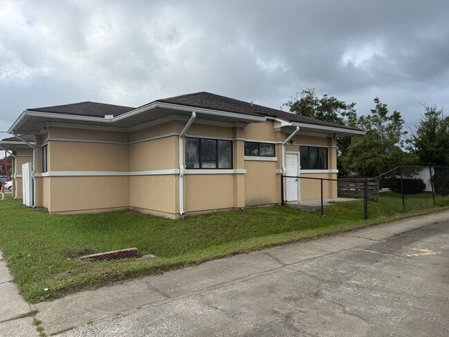
This Property Is For Sale
Property Detail
6531 103Rd St
014310-0010
5-93 12-3S-25E .23 JACKSONVILLE HEIGHTS PT TRACT 14 RECD O/R 12212-1873 BLK 4
Medicalbuilding
Duval
CCG-1
Florida
B and X Area of moderate flood hazard, usually the area between the limits of the 100-year and 500-year floods.
0.24 AC
2025
Riverside
2026
Jacksonville (Florida)
012800
Jacksonville, FL
2,366 SF
NEARBY LISTINGS FOR SALE OR LEASE
DEMOGRAPHICS near 6531 103Rd St
1 mile
3 mile
5 mile
2025 Total Population
8,738
91,310
193,932
2030 Population
9,225
96,932
205,696
Pop Growth 2025-2030
+ 5.57%
+ 6.16%
+ 6.07%
Average Age
39
38
38
2025 Total Households
3,270
35,465
76,533
HH Growth 2025-2030
+ 5.90%
+ 6.50%
+ 6.36%
Median Household Inc
$57,364
$58,361
$63,478
Avg Household Size
2.60
2.50
2.50
2025 Avg HH Vehicles
2.00
2.00
2.00
Median Home Value
$192,107
$230,037
$256,660
Median Year Built
1967
1981
1982
Nearby Places
Map Layers
Map Styles
 Street
 Aerial
Layers
 Traffic
 Biking
Places
Listings with unknown addresses are not visible on the map
- Restaurants
- Banks
- Shops
- Fitness
- Groceries
PUBLIC TRANSPORTATION
AIRPORT
Jacksonville International
Drive
Walk
Distance
Jacksonville International
32 min
22.4 mi
Nearby Properties
Address
Land Use
TOTAL SIZE
Lot Size
Zoning
Address
Land Use
TOTAL SIZE
Lot Size
Zoning
744,280 SF
53.40 AC
RMD-D
Address
Land Use
TOTAL SIZE
Lot Size
Zoning
402,240 SF
20.66 AC
PUD
Address
Land Use
TOTAL SIZE
Lot Size
Zoning
184,092 SF
21.69 AC
CCG-1
Address
Land Use
TOTAL SIZE
Lot Size
Zoning
179,916 SF
12.19 AC
RMD-D
Address
Land Use
TOTAL SIZE
Lot Size
Zoning
188,666 SF
17.76 AC
PUD
Address
Land Use
TOTAL SIZE
Lot Size
Zoning
416,674 SF
18.38 AC
RMD-D
Address
Land Use
TOTAL SIZE
Lot Size
Zoning
203,724 SF
14.71 AC
RMD-D
Address
Land Use
TOTAL SIZE
Lot Size
Zoning
309,137 SF
20.09 AC
RMD-D
Address
Land Use
TOTAL SIZE
Lot Size
Zoning
272,076 SF
54.84 AC
PUD
Address
Land Use
TOTAL SIZE
Lot Size
Zoning
188,578 SF
13.44 AC
RMD-D
Address
Land Use
TOTAL SIZE
Lot Size
Zoning
228,290 SF
12.65 AC
RMD-D
Address
Land Use
TOTAL SIZE
Lot Size
Zoning
277,225 SF
11.72 AC
RMD-D
Address
Land Use
TOTAL SIZE
Lot Size
Zoning
207,697 SF
16.06 AC
PUD
Address
Land Use
TOTAL SIZE
Lot Size
Zoning
96,314 SF
21.05 AC
CCG-1
Address
Land Use
TOTAL SIZE
Lot Size
Zoning
206,513 SF
9.83 AC
RMD-D
Address
Land Use
TOTAL SIZE
Lot Size
Zoning
231,044 SF
10.94 AC
RMD-D
Address
Land Use
TOTAL SIZE
Lot Size
Zoning
137,636 SF
9.73 AC
RMD-D
Address
Land Use
TOTAL SIZE
Lot Size
Zoning
171,412 SF
16.44 AC
RMD-D
Address
Land Use
TOTAL SIZE
Lot Size
Zoning
70,460 SF
1.66 AC
CCG-2
Address
Land Use
TOTAL SIZE
Lot Size
Zoning
169,084 SF
13 AC
CCG-1
Address
Land Use
TOTAL SIZE
Lot Size
Zoning
229,441 SF
17.48 AC
PUD
Address
Land Use
TOTAL SIZE
Lot Size
Zoning
152,768 SF
9.66 AC
RMD-D
Address
Land Use
TOTAL SIZE
Lot Size
Zoning
67,581 SF
24.24 AC
PUD
Address
Land Use
TOTAL SIZE
Lot Size
Zoning
113,479 SF
7.32 AC
PUD
Address
Land Use
TOTAL SIZE
Lot Size
Zoning
103,833 SF
19.32 AC
PUD
Address
Land Use
TOTAL SIZE
Lot Size
Zoning
159,337 SF
11.09 AC
RMD-D
Address
Land Use
TOTAL SIZE
Lot Size
Zoning
209,238 SF
10.31 AC
RMD-D
Address
Land Use
TOTAL SIZE
Lot Size
Zoning
193,478 SF
10.13 AC
RMD-D
Address
Land Use
TOTAL SIZE
Lot Size
Zoning
160,634 SF
16.36 AC
RMD-D
Address
Land Use
TOTAL SIZE
Lot Size
Zoning
57,762 SF
11.90 AC
CCG-2
The World's #1 Commercial Real Estate Marketplace
Connect with us
© 2026 CoStar Group
The information above has been obtained from sources believed reliable. While we do not doubt its accuracy we have not verified it and make no guarantee, warranty or representation about it. It is your responsibility to independently confirm its accuracy and completeness. Any projections, opinions, assumptions, or estimates used are for example only and do not represent the current or future performance of the property. The value of this transaction to you depends on tax and other factors which should be evaluated by your tax, financial, and legal advisors. You and your advisors should conduct a careful, independent investigation of the property to determine to your satisfaction the suitability of the property for your needs.