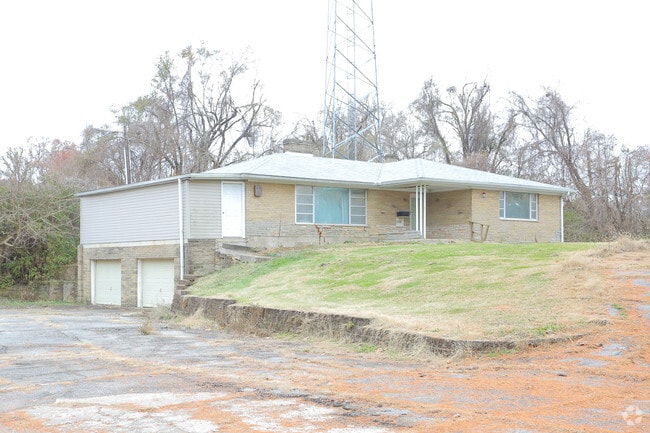
Property Record
6532 State Route 162, Maryville, IL 62062


NEARBY LISTINGS FOR SALE OR LEASE
Property Detail
6532 State Route 162
St. Louis, MO-IL
SW4 T03N R08W
13-1-21-02-03-301-010
Madison
Residentialacreage
Illinois
2024
2.24 AC
2024
Metro East Illinois
403533
St. Louis
1,998 SF
DEMOGRAPHICS near 6532 State Route 162
1 Mile
3 Mile
5 Mile
2024 Total Population
4,249
29,735
75,162
2029 Population
4,168
29,268
74,299
Pop Growth 2024-2029
(1.91%)
(1.57%)
(1.15%)
Average Age
43
42
41
2024 Total Households
1,776
11,818
29,859
HH Growth 2024-2029
(2.03%)
(1.68%)
(1.17%)
Median Household Inc
$83,786
$90,592
$81,714
Avg Household Size
2.30
2.40
2.40
2024 Avg HH Vehicles
2.00
2.00
2.00
Median Home Value
$200,911
$229,632
$211,072
Median Year Built
1986
1990
1985
Nearby Places
Map Layers
Map Styles
 Street
 Aerial
- Restaurants
- Banks
- Shops
- Fitness
- Groceries
PUBLIC TRANSPORTATION
AIRPORT
Scott AFB/Midamerica St Louis
DRIVE
WALK
Distance
Scott AFB/Midamerica St Louis
38 min
23.3 mi
St Louis Lambert International
DRIVE
WALK
Distance
St Louis Lambert International
34 min
24.6 mi
Freight Ports
Port Milwaukee
DRIVE
WALK
Distance
Port Milwaukee
398 min
353.6 mi
SALE & LEASE HISTORY
LISTING DATE
SALE/LEASE

Nov 21, 2018
For Sale
Dec 10, 2020
For Sale
Nearby Properties
Address
Land Use
TOTAL SIZE
Lot Size
Zoning
Address
Land Use
TOTAL SIZE
Lot Size
Zoning
10.83 AC
Address
Land Use
TOTAL SIZE
Lot Size
Zoning
3,209 SF
8.62 AC
Address
Land Use
TOTAL SIZE
Lot Size
Zoning
218,837 SF
4.81 AC
Address
Land Use
TOTAL SIZE
Lot Size
Zoning
25,675 SF
3 AC
Address
Land Use
TOTAL SIZE
Lot Size
Zoning
187,818 SF
12.47 AC
Address
Land Use
TOTAL SIZE
Lot Size
Zoning
85,519 SF
10.09 AC
Address
Land Use
TOTAL SIZE
Lot Size
Zoning
22,816 SF
40.45 AC
Address
Land Use
TOTAL SIZE
Lot Size
Zoning
127,592 SF
11.63 AC
Address
Land Use
TOTAL SIZE
Lot Size
Zoning
131,853 SF
14.60 AC
Address
Land Use
TOTAL SIZE
Lot Size
Zoning
37,432 SF
2 AC
Address
Land Use
TOTAL SIZE
Lot Size
Zoning
30,968 SF
6.32 AC
Address
Land Use
TOTAL SIZE
Lot Size
Zoning
5,280 SF
3.69 AC
Address
Land Use
TOTAL SIZE
Lot Size
Zoning
93,098 SF
15.82 AC
Address
Land Use
TOTAL SIZE
Lot Size
Zoning
72,233 SF
4.94 AC
Address
Land Use
TOTAL SIZE
Lot Size
Zoning
12,900 SF
5.76 AC
Address
Land Use
TOTAL SIZE
Lot Size
Zoning
48,241 SF
2.03 AC
Address
Land Use
TOTAL SIZE
Lot Size
Zoning
46,916 SF
2.58 AC
Address
Land Use
TOTAL SIZE
Lot Size
Zoning
35,046 SF
6.82 AC
Address
Land Use
TOTAL SIZE
Lot Size
Zoning
3,620 SF
18 AC
Address
Land Use
TOTAL SIZE
Lot Size
Zoning
36,845 SF
4 AC
Address
Land Use
TOTAL SIZE
Lot Size
Zoning
8,110 SF
13.83 AC
Address
Land Use
TOTAL SIZE
Lot Size
Zoning
26,408 SF
2.94 AC
Address
Land Use
TOTAL SIZE
Lot Size
Zoning
5,280 SF
2.72 AC
Address
Land Use
TOTAL SIZE
Lot Size
Zoning
27,600 SF
3.71 AC
Address
Land Use
TOTAL SIZE
Lot Size
Zoning
2,262 SF
4.76 AC
Address
Land Use
TOTAL SIZE
Lot Size
Zoning
7,150 SF
7.63 AC
Address
Land Use
TOTAL SIZE
Lot Size
Zoning
75,130 SF
8.12 AC
Address
Land Use
TOTAL SIZE
Lot Size
Zoning
33,476 SF
Address
Land Use
TOTAL SIZE
Lot Size
Zoning
31,024 SF
11.62 AC
Address
Land Use
TOTAL SIZE
Lot Size
Zoning
12,751 SF
0.68 AC
The World's #1 Commercial Real Estate Marketplace
Connect with us
© 2026 CoStar Group
The information above has been obtained from sources believed reliable. While we do not doubt its accuracy we have not verified it and make no guarantee, warranty or representation about it. It is your responsibility to independently confirm its accuracy and completeness. Any projections, opinions, assumptions, or estimates used are for example only and do not represent the current or future performance of the property. The value of this transaction to you depends on tax and other factors which should be evaluated by your tax, financial, and legal advisors. You and your advisors should conduct a careful, independent investigation of the property to determine to your satisfaction the suitability of the property for your needs.