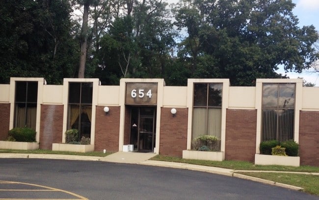
Property Record
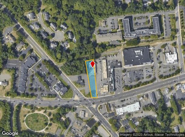
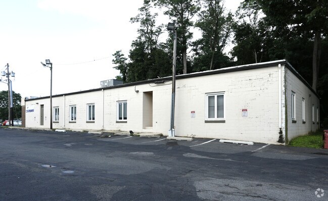
654 Newman Springs Rd, Lincroft, NJ 07738

Current Lease Availabilities
NEARBY LISTINGS FOR SALE OR LEASE
Property Detail
654 Newman Springs Rd
32-01072-0000-00044
Monmouth
Officebuilding
New Jersey
X
44
34025C0178F
0.52 AC
2024
Eastern Monmouth
2025
Northern New Jersey
801500
New York-Jersey City-White Plains, NY-NJ
7,016 SF
DEMOGRAPHICS near 654 Newman Springs Rd
1 Mile
3 Mile
5 Mile
2024 Total Population
4,788
37,862
92,916
2029 Population
4,727
37,574
91,968
Pop Growth 2024-2029
(1.27%)
(0.76%)
(1.02%)
Average Age
42
43
42
2024 Total Households
1,657
13,877
34,619
HH Growth 2024-2029
(1.51%)
(0.94%)
(1.29%)
Median Household Inc
$168,833
$128,679
$131,689
Avg Household Size
2.80
2.60
2.60
2024 Avg HH Vehicles
2.00
2.00
2.00
Median Home Value
$666,581
$627,974
$643,479
Median Year Built
1972
1972
1971
Nearby Places
Map Layers
Map Styles
 Street
 Aerial
- Restaurants
- Banks
- Shops
- Fitness
- Groceries
PUBLIC TRANSPORTATION
COMMUTER RAIL
Red Bank (North Jersey Coast Line - NJ Transit Commuter Rail (NJ Transit))
DRIVE
WALK
Distance
Red Bank (North Jersey Coast Line - NJ Transit Commuter Rail (NJ Transit))
7 min
3.4 mi
DRIVE
WALK
Distance
9 min
4.5 mi
AIRPORT
Newark Liberty International
DRIVE
WALK
Distance
Newark Liberty International
50 min
40.7 mi
Freight Ports
New York Container Terminal
DRIVE
WALK
Distance
New York Container Terminal
44 min
32.8 mi
Nearby Properties
Address
Land Use
TOTAL SIZE
Lot Size
Zoning
Address
Land Use
TOTAL SIZE
Lot Size
Zoning
44,186 SF
152.90 AC
R220
Address
Land Use
TOTAL SIZE
Lot Size
Zoning
Address
Land Use
TOTAL SIZE
Lot Size
Zoning
199,680 SF
44 SF
MU08
Address
Land Use
TOTAL SIZE
Lot Size
Zoning
1.92 AC
WD
Address
Land Use
TOTAL SIZE
Lot Size
Zoning
164,700 SF
136.76 AC
R220
Address
Land Use
TOTAL SIZE
Lot Size
Zoning
154,970 SF
1.83 AC
BR-1
Address
Land Use
TOTAL SIZE
Lot Size
Zoning
75,046 SF
6.06 AC
BP
Address
Land Use
TOTAL SIZE
Lot Size
Zoning
241,154 SF
84 AC
R-30
Address
Land Use
TOTAL SIZE
Lot Size
Zoning
181,867 SF
31.90 AC
RA
Address
Land Use
TOTAL SIZE
Lot Size
Zoning
9,810 SF
205 AC
R220
Address
Land Use
TOTAL SIZE
Lot Size
Zoning
12,269 SF
3.60 AC
B-3
Address
Land Use
TOTAL SIZE
Lot Size
Zoning
97,572 SF
2.57 AC
MU08
Address
Land Use
TOTAL SIZE
Lot Size
Zoning
201,791 SF
10.50 AC
BP
Address
Land Use
TOTAL SIZE
Lot Size
Zoning
91,564 SF
2.45 AC
BR-1
Address
Land Use
TOTAL SIZE
Lot Size
Zoning
83.83 AC
BR-1
Address
Land Use
TOTAL SIZE
Lot Size
Zoning
86,586 SF
4.83 AC
R-4
Address
Land Use
TOTAL SIZE
Lot Size
Zoning
153,006 SF
3.52 AC
RHA1
Address
Land Use
TOTAL SIZE
Lot Size
Zoning
10,473 SF
214.74 AC
AGCL
Address
Land Use
TOTAL SIZE
Lot Size
Zoning
30,000 SF
10.03 AC
LI
Address
Land Use
TOTAL SIZE
Lot Size
Zoning
896 SF
135.37 AC
P
Address
Land Use
TOTAL SIZE
Lot Size
Zoning
5,014 SF
153.81 AC
R-22
Address
Land Use
TOTAL SIZE
Lot Size
Zoning
Address
Land Use
TOTAL SIZE
Lot Size
Zoning
107,553 SF
16 AC
BP
Address
Land Use
TOTAL SIZE
Lot Size
Zoning
107,553 SF
8.70 AC
BP
Address
Land Use
TOTAL SIZE
Lot Size
Zoning
18,033 SF
21.74 AC
R-1
Address
Land Use
TOTAL SIZE
Lot Size
Zoning
86,950 SF
30.35 AC
R-1
Address
Land Use
TOTAL SIZE
Lot Size
Zoning
45,339 SF
18.65 AC
B-1
Address
Land Use
TOTAL SIZE
Lot Size
Zoning
37,626 SF
30.06 AC
R-1
Address
Land Use
TOTAL SIZE
Lot Size
Zoning
80,762 SF
5.63 AC
OR-1
Address
Land Use
TOTAL SIZE
Lot Size
Zoning
132.51 AC
P
The World's #1 Commercial Real Estate Marketplace
Connect with us
© 2026 CoStar Group
The information above has been obtained from sources believed reliable. While we do not doubt its accuracy we have not verified it and make no guarantee, warranty or representation about it. It is your responsibility to independently confirm its accuracy and completeness. Any projections, opinions, assumptions, or estimates used are for example only and do not represent the current or future performance of the property. The value of this transaction to you depends on tax and other factors which should be evaluated by your tax, financial, and legal advisors. You and your advisors should conduct a careful, independent investigation of the property to determine to your satisfaction the suitability of the property for your needs.