Property Record
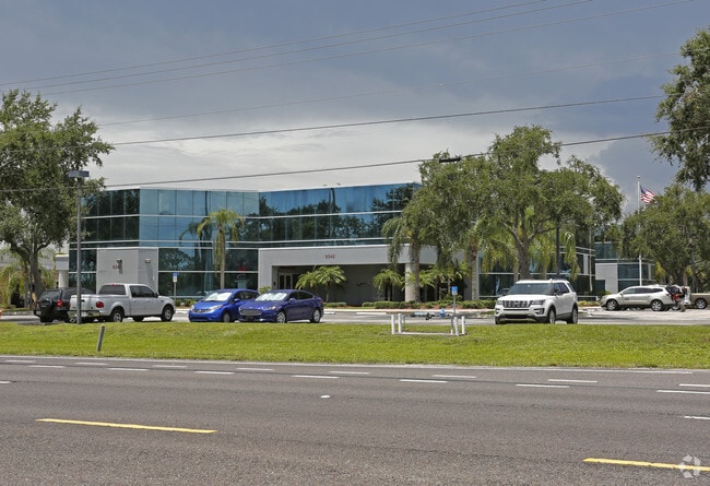
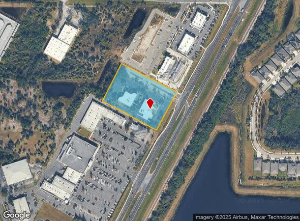
6542 N Us Highway 41 Hwy, Apollo Beach, FL 33572

NEARBY LISTINGS FOR SALE OR LEASE
Property Detail
6542 N Us Highway 41 Hwy
Tampa-St. Petersburg-Clearwater, FL
Ruskin Tomato Farms
U-22-31-19-1SF-000000-60800.0
RUSKIN TOMATO FARMS PART OF TRACT 30 DESC AS FR NE COR OF 22-31-19 S 89 DEG 21 MIN 45 SEC W 718.70 FT TO WLY R/W SR 45 S 27 DEG 17 MIN 16 SEC W 1569.69 FT CONT S 27 DEG 17 MIN 16 SEC W 705.60 FT TO POB CONT S 27 DEG 17 MIN 16 SEC W 300 FT N 62 DEG 42
Officebuilding
Hillsborough
X
Florida
12057C0494J
60800
2024
3.01 AC
2024
Southeast Hillsborough
014106
Tampa/St Petersburg
32,902 SF
DEMOGRAPHICS near 6542 N Us Highway 41 Hwy
1 Mile
3 Mile
5 Mile
2024 Total Population
6,898
45,507
132,285
2029 Population
7,766
51,460
148,063
Pop Growth 2024-2029
+ 12.58%
+ 13.08%
+ 11.93%
Average Age
42
41
42
2024 Total Households
2,708
16,732
49,103
HH Growth 2024-2029
+ 12.74%
+ 13.17%
+ 12.27%
Median Household Inc
$95,165
$98,589
$82,466
Avg Household Size
2.50
2.70
2.60
2024 Avg HH Vehicles
2.00
2.00
2.00
Median Home Value
$344,117
$357,990
$280,229
Median Year Built
2005
2010
2008
Nearby Places
Map Layers
Map Styles
 Street
 Aerial
- Restaurants
- Banks
- Shops
- Fitness
- Groceries
PUBLIC TRANSPORTATION
AIRPORT
Tampa International
DRIVE
WALK
Distance
Tampa International
40 min
24.3 mi
Sarasota/Bradenton International
DRIVE
WALK
Distance
Sarasota/Bradenton International
50 min
32.4 mi
St Pete-Clearwater International
DRIVE
WALK
Distance
St Pete-Clearwater International
57 min
34.4 mi
Freight Ports
Port of Tampa Bay
DRIVE
WALK
Distance
Port of Tampa Bay
24 min
14.5 mi
Nearby Properties
Address
Land Use
TOTAL SIZE
Lot Size
Zoning
Address
Land Use
TOTAL SIZE
Lot Size
Zoning
503,703 SF
21 AC
PD
Address
Land Use
TOTAL SIZE
Lot Size
Zoning
493,204 SF
65.35 AC
M
Address
Land Use
TOTAL SIZE
Lot Size
Zoning
593,167 SF
416.07 AC
M
Address
Land Use
TOTAL SIZE
Lot Size
Zoning
334,559 SF
27.53 AC
PD
Address
Land Use
TOTAL SIZE
Lot Size
Zoning
334,871 SF
15 AC
PD
Address
Land Use
TOTAL SIZE
Lot Size
Zoning
154,232 SF
17.40 AC
PD
Address
Land Use
TOTAL SIZE
Lot Size
Zoning
347,147 SF
258.94 AC
PD
Address
Land Use
TOTAL SIZE
Lot Size
Zoning
425,231 SF
23.78 AC
M
Address
Land Use
TOTAL SIZE
Lot Size
Zoning
101,768 SF
17.94 AC
PD
Address
Land Use
TOTAL SIZE
Lot Size
Zoning
146,440 SF
18.56 AC
PD
Address
Land Use
TOTAL SIZE
Lot Size
Zoning
48,968 SF
10 AC
PD
Address
Land Use
TOTAL SIZE
Lot Size
Zoning
520,366 SF
122.24 AC
PD
Address
Land Use
TOTAL SIZE
Lot Size
Zoning
441,257 SF
107.09 AC
AR
Address
Land Use
TOTAL SIZE
Lot Size
Zoning
138,397 SF
36.94 AC
PD
Address
Land Use
TOTAL SIZE
Lot Size
Zoning
178,496 SF
17.63 AC
PD
Address
Land Use
TOTAL SIZE
Lot Size
Zoning
64,512 SF
22.33 AC
PD
Address
Land Use
TOTAL SIZE
Lot Size
Zoning
77,315 SF
9.71 AC
CG
Address
Land Use
TOTAL SIZE
Lot Size
Zoning
93,256 SF
14.82 AC
PD
Address
Land Use
TOTAL SIZE
Lot Size
Zoning
108,036 SF
11.70 AC
PD
Address
Land Use
TOTAL SIZE
Lot Size
Zoning
94,955 SF
13.55 AC
PD
Address
Land Use
TOTAL SIZE
Lot Size
Zoning
230,880 SF
25.13 AC
AI
Address
Land Use
TOTAL SIZE
Lot Size
Zoning
191,459 SF
13.60 AC
M
Address
Land Use
TOTAL SIZE
Lot Size
Zoning
88,445 SF
14.41 AC
PD
Address
Land Use
TOTAL SIZE
Lot Size
Zoning
81,193 SF
11.41 AC
PD
Address
Land Use
TOTAL SIZE
Lot Size
Zoning
110,148 SF
23.04 AC
M
Address
Land Use
TOTAL SIZE
Lot Size
Zoning
40,676 SF
8.56 AC
M
Address
Land Use
TOTAL SIZE
Lot Size
Zoning
113,683 SF
14.51 AC
PD
Address
Land Use
TOTAL SIZE
Lot Size
Zoning
76,280 SF
3.87 AC
PD
Address
Land Use
TOTAL SIZE
Lot Size
Zoning
123,538 SF
8.88 AC
M
Address
Land Use
TOTAL SIZE
Lot Size
Zoning
57,822 SF
47.69 AC
AR
The World's #1 Commercial Real Estate Marketplace
Connect with us
© 2025 CoStar Group
The information above has been obtained from sources believed reliable. While we do not doubt its accuracy we have not verified it and make no guarantee, warranty or representation about it. It is your responsibility to independently confirm its accuracy and completeness. Any projections, opinions, assumptions, or estimates used are for example only and do not represent the current or future performance of the property. The value of this transaction to you depends on tax and other factors which should be evaluated by your tax, financial, and legal advisors. You and your advisors should conduct a careful, independent investigation of the property to determine to your satisfaction the suitability of the property for your needs.