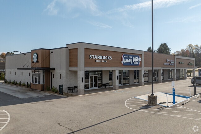
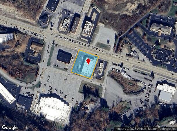
Property Record
6543 State Route 22 Hwy, Delmont, PA 15626
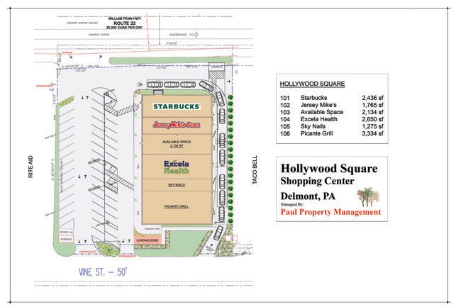

Current Lease Availabilities
NEARBY LISTINGS FOR SALE OR LEASE
Property Detail
6543 State Route 22 Hwy
Pittsburgh, PA
Parcel 1B In Revision To The Links
57-12-00-0-041
LT 1-B & BLDG LINKS REV 5 214 X 244
Commercialofficeresidentialmixeduse
Westmoreland
X
Pennsylvania
42129C0214F
1
2025
1.10 AC
2025
Westmoreland County
801901
Pittsburgh
13,515 SF
DEMOGRAPHICS near 6543 State Route 22 Hwy
1 Mile
3 Mile
5 Mile
2024 Total Population
3,231
12,680
36,684
2029 Population
3,201
12,575
36,291
Pop Growth 2024-2029
(0.93%)
(0.83%)
(1.07%)
Average Age
49
46
45
2024 Total Households
1,518
5,490
15,516
HH Growth 2024-2029
(0.92%)
(0.86%)
(1.14%)
Median Household Inc
$65,974
$76,820
$81,472
Avg Household Size
2.10
2.30
2.30
2024 Avg HH Vehicles
2.00
2.00
2.00
Median Home Value
$199,397
$215,743
$231,057
Median Year Built
1976
1973
1975
Nearby Places
Map Layers
Map Styles
 Street
 Aerial
- Restaurants
- Banks
- Shops
- Fitness
- Groceries
PUBLIC TRANSPORTATION
COMMUTER RAIL
DRIVE
WALK
Distance
14 min
9.0 mi
AIRPORT
Arnold Palmer Regional
DRIVE
WALK
Distance
Arnold Palmer Regional
32 min
18.9 mi
Pittsburgh International
DRIVE
WALK
Distance
Pittsburgh International
63 min
40.9 mi
Nearby Properties
Address
Land Use
TOTAL SIZE
Lot Size
Zoning
Address
Land Use
TOTAL SIZE
Lot Size
Zoning
16.72 AC
Address
Land Use
TOTAL SIZE
Lot Size
Zoning
Address
Land Use
TOTAL SIZE
Lot Size
Zoning
144,341 SF
24.87 AC
Address
Land Use
TOTAL SIZE
Lot Size
Zoning
19.40 AC
Address
Land Use
TOTAL SIZE
Lot Size
Zoning
51,970 SF
6.59 AC
Address
Land Use
TOTAL SIZE
Lot Size
Zoning
38,219 SF
10 AC
Address
Land Use
TOTAL SIZE
Lot Size
Zoning
33,070 SF
5.22 AC
Address
Land Use
TOTAL SIZE
Lot Size
Zoning
3.06 AC
Address
Land Use
TOTAL SIZE
Lot Size
Zoning
179,326 SF
14.10 AC
Address
Land Use
TOTAL SIZE
Lot Size
Zoning
6,144 SF
135.10 AC
Address
Land Use
TOTAL SIZE
Lot Size
Zoning
160,695 SF
12.20 AC
Address
Land Use
TOTAL SIZE
Lot Size
Zoning
37.39 AC
Address
Land Use
TOTAL SIZE
Lot Size
Zoning
28,802 SF
6.42 AC
Address
Land Use
TOTAL SIZE
Lot Size
Zoning
34,896 SF
106.40 AC
Address
Land Use
TOTAL SIZE
Lot Size
Zoning
Address
Land Use
TOTAL SIZE
Lot Size
Zoning
95,786 SF
12.50 AC
Address
Land Use
TOTAL SIZE
Lot Size
Zoning
5.23 AC
Address
Land Use
TOTAL SIZE
Lot Size
Zoning
137,545 SF
8.90 AC
Address
Land Use
TOTAL SIZE
Lot Size
Zoning
23,328 SF
4.35 AC
Address
Land Use
TOTAL SIZE
Lot Size
Zoning
63,750 SF
3.10 AC
Address
Land Use
TOTAL SIZE
Lot Size
Zoning
35,148 SF
2.77 AC
Address
Land Use
TOTAL SIZE
Lot Size
Zoning
10.59 AC
Address
Land Use
TOTAL SIZE
Lot Size
Zoning
54,000 SF
6.67 AC
Address
Land Use
TOTAL SIZE
Lot Size
Zoning
179,326 SF
17 AC
Address
Land Use
TOTAL SIZE
Lot Size
Zoning
19,200 SF
3.67 AC
Address
Land Use
TOTAL SIZE
Lot Size
Zoning
46,332 SF
8.69 AC
Address
Land Use
TOTAL SIZE
Lot Size
Zoning
2.55 AC
Address
Land Use
TOTAL SIZE
Lot Size
Zoning
25,200 SF
1.10 AC
Address
Land Use
TOTAL SIZE
Lot Size
Zoning
51,040 SF
10.67 AC
Address
Land Use
TOTAL SIZE
Lot Size
Zoning
11,432 SF
1.24 AC
The World's #1 Commercial Real Estate Marketplace
Connect with us
© 2025 CoStar Group
The information above has been obtained from sources believed reliable. While we do not doubt its accuracy we have not verified it and make no guarantee, warranty or representation about it. It is your responsibility to independently confirm its accuracy and completeness. Any projections, opinions, assumptions, or estimates used are for example only and do not represent the current or future performance of the property. The value of this transaction to you depends on tax and other factors which should be evaluated by your tax, financial, and legal advisors. You and your advisors should conduct a careful, independent investigation of the property to determine to your satisfaction the suitability of the property for your needs.