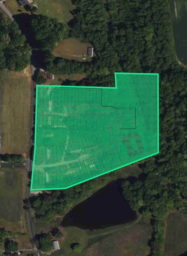
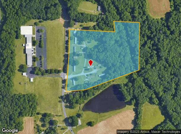
Property Record
6560 Weant Rd, High Point, NC 27263
This Property Is For Sale
NEARBY LISTINGS FOR SALE OR LEASE
Property Detail
6560 Weant Rd
7728-56-1758
Property Of Homer V Weant Estate
Sfr
R1916;TR 4 & 6
AE
Randolph
3710772800K
North Carolina
2025
10.80 AC
2025
NW Randolph Cnty/Archdale
031304
Greensboro/Winston-Salem
804 SF
Greensboro-High Point, NC
DEMOGRAPHICS near 6560 Weant Rd
1 mile
3 mile
5 mile
2024 Total Population
2,916
17,696
49,007
2029 Population
3,087
18,672
51,872
Pop Growth 2024-2029
+ 5.86%
+ 5.52%
+ 5.85%
Average Age
43
42
40
2024 Total Households
1,131
7,205
19,509
HH Growth 2024-2029
+ 6.01%
+ 5.72%
+ 6.05%
Median Household Inc
$60,545
$54,668
$49,748
Avg Household Size
2.50
2.40
2.50
2024 Avg HH Vehicles
3.00
2.00
2.00
Median Home Value
$263,080
$202,418
$193,226
Median Year Built
1992
1979
1977
Nearby Places
Map Layers
Map Styles
 Street
 Aerial
Transit
 Traffic
 Biking
Places
Listings with unknown addresses are not visible on the map
- Restaurants
- Banks
- Shops
- Fitness
- Groceries
PUBLIC TRANSPORTATION
COMMUTER RAIL
High Point Station (Piedmont - North Carolina by Train (NC Train))
Drive
Walk
Distance
High Point Station (Piedmont - North Carolina by Train (NC Train))
16 min
6.9 mi
AIRPORT
Piedmont Triad International
Drive
Walk
Distance
Piedmont Triad International
35 min
21.7 mi
Nearby Properties
Address
Land Use
TOTAL SIZE
Lot Size
Zoning
Address
Land Use
TOTAL SIZE
Lot Size
Zoning
127,800 SF
57.35 AC
M-1
Address
Land Use
TOTAL SIZE
Lot Size
Zoning
159,944 SF
13.95 AC
RS-40
Address
Land Use
TOTAL SIZE
Lot Size
Zoning
107,417 SF
6.46 AC
RM-26
Address
Land Use
TOTAL SIZE
Lot Size
Zoning
299,394 SF
8.60 AC
M-2
Address
Land Use
TOTAL SIZE
Lot Size
Zoning
90,000 SF
15.36 AC
M-2
Address
Land Use
TOTAL SIZE
Lot Size
Zoning
7,680 SF
9.95 AC
GRD
Address
Land Use
TOTAL SIZE
Lot Size
Zoning
69,094 SF
5.47 AC
M-2
Address
Land Use
TOTAL SIZE
Lot Size
Zoning
7,168 SF
7.51 AC
GRD
Address
Land Use
TOTAL SIZE
Lot Size
Zoning
73,658 SF
8.45 AC
B-1
Address
Land Use
TOTAL SIZE
Lot Size
Zoning
199,250 SF
54.80 AC
M-1
Address
Land Use
TOTAL SIZE
Lot Size
Zoning
48,913 SF
2.25 AC
B-1
Address
Land Use
TOTAL SIZE
Lot Size
Zoning
47,822 SF
5.76 AC
SU R-10
Address
Land Use
TOTAL SIZE
Lot Size
Zoning
35,620 SF
5.47 AC
M-2
Address
Land Use
TOTAL SIZE
Lot Size
Zoning
65,733 SF
124.36 AC
HI
Address
Land Use
TOTAL SIZE
Lot Size
Zoning
53,520 SF
5.48 AC
B-1
Address
Land Use
TOTAL SIZE
Lot Size
Zoning
8,927 SF
3.60 AC
OI
Address
Land Use
TOTAL SIZE
Lot Size
Zoning
40,275 SF
2.31 AC
B-1
Address
Land Use
TOTAL SIZE
Lot Size
Zoning
42,112 SF
6.41 AC
HB
Address
Land Use
TOTAL SIZE
Lot Size
Zoning
99,722 SF
38.11 AC
M-2
Address
Land Use
TOTAL SIZE
Lot Size
Zoning
43,328 SF
2.11 AC
B-1
Address
Land Use
TOTAL SIZE
Lot Size
Zoning
37,680 SF
1.66 AC
CD HB
Address
Land Use
TOTAL SIZE
Lot Size
Zoning
18.23 AC
R-15
Address
Land Use
TOTAL SIZE
Lot Size
Zoning
17,966 SF
4.17 AC
RBO-CD
Address
Land Use
TOTAL SIZE
Lot Size
Zoning
27,601 SF
8.28 AC
SU R-10
Address
Land Use
TOTAL SIZE
Lot Size
Zoning
41,876 SF
21 AC
R-5
Address
Land Use
TOTAL SIZE
Lot Size
Zoning
33,423 SF
4.48 AC
R-5
Address
Land Use
TOTAL SIZE
Lot Size
Zoning
22,202 SF
2.30 AC
B-1
Address
Land Use
TOTAL SIZE
Lot Size
Zoning
19,156 SF
2.33 AC
B-1
Address
Land Use
TOTAL SIZE
Lot Size
Zoning
2,880 SF
2.91 AC
B-1
Address
Land Use
TOTAL SIZE
Lot Size
Zoning
2,817 SF
101.78 AC
HI
The World's #1 Commercial Real Estate Marketplace
Connect with us
© 2026 CoStar Group
The information above has been obtained from sources believed reliable. While we do not doubt its accuracy we have not verified it and make no guarantee, warranty or representation about it. It is your responsibility to independently confirm its accuracy and completeness. Any projections, opinions, assumptions, or estimates used are for example only and do not represent the current or future performance of the property. The value of this transaction to you depends on tax and other factors which should be evaluated by your tax, financial, and legal advisors. You and your advisors should conduct a careful, independent investigation of the property to determine to your satisfaction the suitability of the property for your needs.