Property Record
655 Tradeport Dr, Summerville, SC 29486


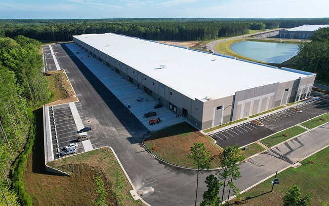
Property Detail
655 Tradeport Dr
207-00-01-056
HARVEY TRACT (MAIN)NEW HOPE TRACTNOW 434.93 AC (07/2021)381.64 AC, NEW HOPE TRACT (08/2023)321.62 AC, NEW HOPE TRACT
Vacantlandnec
BERKELEY
BERKELEY C
South Carolina
AE The base floodplain where base flood elevations are provided. AE Zones are now used on new format FIRMs instead of A1-A30 Zones.
267.24 AC
2025
Outlying Berkeley County
2025
Charleston/N Charleston
020710
Charleston-North Charleston, SC
NEARBY LISTINGS FOR SALE OR LEASE
DEMOGRAPHICS near 655 Tradeport Dr
1 mile
3 mile
5 mile
2025 Total Population
1,472
6,100
41,022
2030 Population
1,672
6,967
46,437
Pop Growth 2025-2030
+ 13.59%
+ 14.21%
+ 13.20%
Average Age
37
38
38
2025 Total Households
496
2,105
14,727
HH Growth 2025-2030
+ 14.11%
+ 14.73%
+ 13.73%
Median Household Inc
$96,725
$92,601
$92,339
Avg Household Size
2.90
2.80
2.70
2025 Avg HH Vehicles
2.00
2.00
2.00
Median Home Value
$291,588
$374,203
$378,586
Median Year Built
2008
2009
2010
Nearby Places
Map Layers
Map Styles
 Street
 Aerial
Layers
 Traffic
 Biking
Places
Listings with unknown addresses are not visible on the map
- Restaurants
- Banks
- Shops
- Fitness
- Groceries
PUBLIC TRANSPORTATION
AIRPORT
Charleston AFB/International
Drive
Walk
Distance
Charleston AFB/International
37 min
23.1 mi
Freight Ports
North Charleston Terminal
Drive
Walk
Distance
North Charleston Terminal
33 min
22.1 mi
SALE & LEASE HISTORY
LISTING DATE
SALE/LEASE

May 24, 2021
For Lease
Jan 24, 2025
For Lease
Nearby Properties
Address
Land Use
TOTAL SIZE
Lot Size
Zoning
Address
Land Use
TOTAL SIZE
Lot Size
Zoning
315,270 SF
25.81 AC
Address
Land Use
TOTAL SIZE
Lot Size
Zoning
849,992 SF
49.12 AC
BERKELEY C
Address
Land Use
TOTAL SIZE
Lot Size
Zoning
758,160 SF
50.45 AC
BERKELEY C
Address
Land Use
TOTAL SIZE
Lot Size
Zoning
611,520 SF
54.75 AC
Address
Land Use
TOTAL SIZE
Lot Size
Zoning
579,120 SF
42.86 AC
Address
Land Use
TOTAL SIZE
Lot Size
Zoning
746,000 SF
49.64 AC
BERKELEY C
Address
Land Use
TOTAL SIZE
Lot Size
Zoning
575,260 SF
49.15 AC
BERKELEY C
Address
Land Use
TOTAL SIZE
Lot Size
Zoning
367,040 SF
22.09 AC
Address
Land Use
TOTAL SIZE
Lot Size
Zoning
362,880 SF
23.56 AC
Address
Land Use
TOTAL SIZE
Lot Size
Zoning
17,000 SF
4.86 AC
BERKELEY C
Address
Land Use
TOTAL SIZE
Lot Size
Zoning
351,520 SF
54.09 AC
BERKELEY C
Address
Land Use
TOTAL SIZE
Lot Size
Zoning
351,520 SF
37.61 AC
BERKELEY C
Address
Land Use
TOTAL SIZE
Lot Size
Zoning
343,200 SF
18.12 AC
HI
Address
Land Use
TOTAL SIZE
Lot Size
Zoning
200,880 SF
35.19 AC
Address
Land Use
TOTAL SIZE
Lot Size
Zoning
340,200 SF
18.88 AC
Address
Land Use
TOTAL SIZE
Lot Size
Zoning
247,288 SF
19.42 AC
BERKELEY C
Address
Land Use
TOTAL SIZE
Lot Size
Zoning
129,780 SF
22.96 AC
OPIP
Address
Land Use
TOTAL SIZE
Lot Size
Zoning
165,750 SF
20.09 AC
BERKELEY C
Address
Land Use
TOTAL SIZE
Lot Size
Zoning
94.14 AC
BERKELEY C
Address
Land Use
TOTAL SIZE
Lot Size
Zoning
Address
Land Use
TOTAL SIZE
Lot Size
Zoning
234.98 AC
BERKELEY C
Address
Land Use
TOTAL SIZE
Lot Size
Zoning
50.28 AC
BERKELEY C
Address
Land Use
TOTAL SIZE
Lot Size
Zoning
117,420 SF
35.87 AC
Address
Land Use
TOTAL SIZE
Lot Size
Zoning
416.26 AC
BERKELEY C
Address
Land Use
TOTAL SIZE
Lot Size
Zoning
10,896 SF
16.27 AC
BERKELEY C
Address
Land Use
TOTAL SIZE
Lot Size
Zoning
56,875 SF
7.08 AC
BERKELEY C
Address
Land Use
TOTAL SIZE
Lot Size
Zoning
61,110 SF
5 AC
BERKELEY C
Address
Land Use
TOTAL SIZE
Lot Size
Zoning
50,910 SF
14.57 AC
BERKELEY C
Address
Land Use
TOTAL SIZE
Lot Size
Zoning
21.81 AC
BERKELEY C
The World's #1 Commercial Real Estate Marketplace
Connect with us
© 2026 CoStar Group
The information above has been obtained from sources believed reliable. While we do not doubt its accuracy we have not verified it and make no guarantee, warranty or representation about it. It is your responsibility to independently confirm its accuracy and completeness. Any projections, opinions, assumptions, or estimates used are for example only and do not represent the current or future performance of the property. The value of this transaction to you depends on tax and other factors which should be evaluated by your tax, financial, and legal advisors. You and your advisors should conduct a careful, independent investigation of the property to determine to your satisfaction the suitability of the property for your needs.