Property Record
6550 E Main St, Mesa, AZ 85205
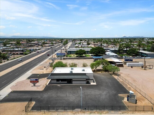

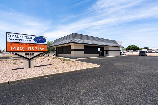
Property Detail
6550 E Main St
141-59-003F
S 150F OF E 125F OF FOL TH PT SW4 NE4 DAF BEG 50F N & 30F W OF SE COR SW4 NE4 TH W 301.04F TH N 383.26F TH E 301.04F TO A PT 30F W OF E LN E2 SE4 SW4 NE4 TH S 383.26F TO POB
Storebuilding
Maricopa
C-G
Arizona
C and X Area of minimal flood hazard, usually depicted on FIRMs as above the 500-year flood level.
0.43 AC
2025
Mesa East
2025
Phoenix
420214
Phoenix-Mesa-Chandler, AZ
2,532 SF
NEARBY LISTINGS FOR SALE OR LEASE
DEMOGRAPHICS near 6550 E Main St
1 mile
3 mile
5 mile
2024 Total Population
12,672
110,944
289,218
2029 Population
13,265
115,999
302,076
Pop Growth 2024-2029
+ 4.68%
+ 4.56%
+ 4.45%
Average Age
54
48
44
2024 Total Households
6,311
49,431
117,109
HH Growth 2024-2029
+ 4.88%
+ 4.93%
+ 4.82%
Median Household Inc
$57,661
$69,606
$81,296
Avg Household Size
1.90
2.20
2.40
2024 Avg HH Vehicles
1.00
2.00
2.00
Median Home Value
$307,328
$351,876
$406,213
Median Year Built
1983
1987
1992
Nearby Places
Map Layers
Map Styles
 Street
 Aerial
Transit
 Traffic
 Biking
Places
Listings with unknown addresses are not visible on the map
- Restaurants
- Banks
- Shops
- Fitness
- Groceries
PUBLIC TRANSPORTATION
AIRPORT
Phoenix-Mesa Gateway
Drive
Walk
Distance
Phoenix-Mesa Gateway
18 min
9.4 mi
Phoenix Sky Harbor International
Drive
Walk
Distance
Phoenix Sky Harbor International
34 min
23.9 mi
SALE & LEASE HISTORY
LISTING DATE
SALE/LEASE

Jul 02, 2025
For Sale
Nearby Properties
Address
Land Use
TOTAL SIZE
Lot Size
Zoning
Address
Land Use
TOTAL SIZE
Lot Size
Zoning
1,522,034 SF
32.67 AC
C-N
Address
Land Use
TOTAL SIZE
Lot Size
Zoning
53,910 SF
4.98 AC
C-G
Address
Land Use
TOTAL SIZE
Lot Size
Zoning
57.25 AC
PF
Address
Land Use
TOTAL SIZE
Lot Size
Zoning
324,534 SF
50.86 AC
PF
Address
Land Use
TOTAL SIZE
Lot Size
Zoning
271,098 SF
142.75 AC
PF
Address
Land Use
TOTAL SIZE
Lot Size
Zoning
279,338 SF
39.90 AC
PF
Address
Land Use
TOTAL SIZE
Lot Size
Zoning
18.75 AC
PF
Address
Land Use
TOTAL SIZE
Lot Size
Zoning
711,933 SF
45.84 AC
Address
Land Use
TOTAL SIZE
Lot Size
Zoning
122,042 SF
15.79 AC
PF
Address
Land Use
TOTAL SIZE
Lot Size
Zoning
129,201 SF
24.65 AC
LI
Address
Land Use
TOTAL SIZE
Lot Size
Zoning
160,296 SF
33.63 AC
PF
Address
Land Use
TOTAL SIZE
Lot Size
Zoning
269,763 SF
17.49 AC
M-H
Address
Land Use
TOTAL SIZE
Lot Size
Zoning
344,619 SF
13.85 AC
M-H
Address
Land Use
TOTAL SIZE
Lot Size
Zoning
140,141 SF
37.70 AC
PF
Address
Land Use
TOTAL SIZE
Lot Size
Zoning
425,158 SF
23.71 AC
M-H
Address
Land Use
TOTAL SIZE
Lot Size
Zoning
307,545 SF
17.61 AC
M-H
Address
Land Use
TOTAL SIZE
Lot Size
Zoning
219,041 SF
5.71 AC
I-1
Address
Land Use
TOTAL SIZE
Lot Size
Zoning
8.82 AC
Address
Land Use
TOTAL SIZE
Lot Size
Zoning
1.61 AC
LC
Address
Land Use
TOTAL SIZE
Lot Size
Zoning
82,772 SF
131.12 AC
PF
Address
Land Use
TOTAL SIZE
Lot Size
Zoning
267,380 SF
17.08 AC
M-H
Address
Land Use
TOTAL SIZE
Lot Size
Zoning
225,660 SF
10.36 AC
M-H
Address
Land Use
TOTAL SIZE
Lot Size
Zoning
203,722 SF
11.73 AC
C-G
Address
Land Use
TOTAL SIZE
Lot Size
Zoning
7.90 AC
Address
Land Use
TOTAL SIZE
Lot Size
Zoning
190,630 SF
6.61 AC
M-H
Address
Land Use
TOTAL SIZE
Lot Size
Zoning
256,284 SF
11.42 AC
M-H
Address
Land Use
TOTAL SIZE
Lot Size
Zoning
187,297 SF
3.99 AC
R-9
Address
Land Use
TOTAL SIZE
Lot Size
Zoning
7.26 AC
Address
Land Use
TOTAL SIZE
Lot Size
Zoning
94,209 SF
14.93 AC
C-G
Address
Land Use
TOTAL SIZE
Lot Size
Zoning
3,545 SF
1.14 AC
C-G
The World's #1 Commercial Real Estate Marketplace
Connect with us
© 2026 CoStar Group
The information above has been obtained from sources believed reliable. While we do not doubt its accuracy we have not verified it and make no guarantee, warranty or representation about it. It is your responsibility to independently confirm its accuracy and completeness. Any projections, opinions, assumptions, or estimates used are for example only and do not represent the current or future performance of the property. The value of this transaction to you depends on tax and other factors which should be evaluated by your tax, financial, and legal advisors. You and your advisors should conduct a careful, independent investigation of the property to determine to your satisfaction the suitability of the property for your needs.