Property Record
6550 Us Highway 9, Howell, NJ 07731

NEARBY LISTINGS FOR SALE OR LEASE
Property Detail
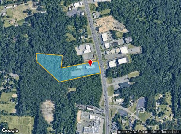
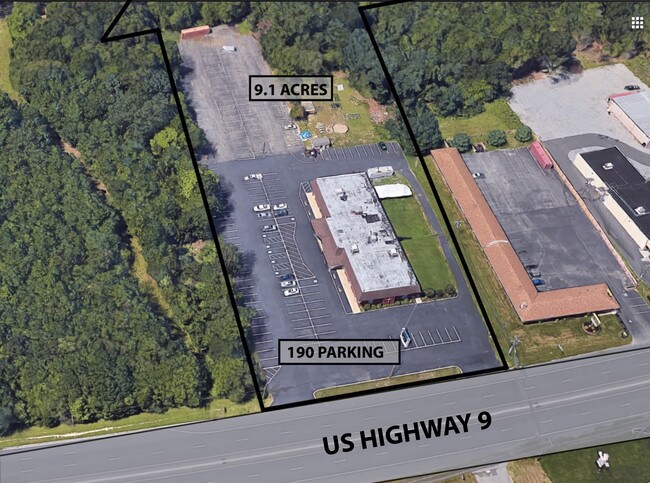
6550 Us Highway 9
21-00071-0000-00014-03
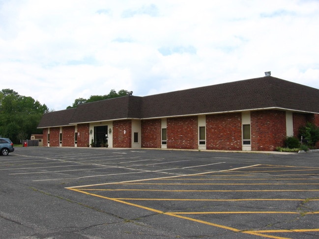
FACILITY NAME: CHURCH
Religious
Monmouth
X
New Jersey
34025C0430F
14.3
0
9 AC
2025
Western Monmouth
811304
Northern New Jersey
10,891 SF
New York-Jersey City-White Plains, NY-NJ
DEMOGRAPHICS near 6550 Us Highway 9
1 Mile
3 Mile
5 Mile
2024 Total Population
6,731
98,030
187,879
2029 Population
6,921
100,318
193,200
Pop Growth 2024-2029
+ 2.82%
+ 2.33%
+ 2.83%
Average Age
28
27
30
2024 Total Households
1,669
21,862
48,967
HH Growth 2024-2029
+ 2.16%
+ 1.05%
+ 1.99%
Median Household Inc
$50,323
$74,438
$78,611
Avg Household Size
3.50
3.90
3.50
2024 Avg HH Vehicles
2.00
2.00
2.00
Median Home Value
$450,999
$412,256
$386,703
Median Year Built
1970
1983
1987
Nearby Places
Map Layers
Map Styles
 Street
 Aerial
- Restaurants
- Banks
- Shops
- Fitness
- Groceries
PUBLIC TRANSPORTATION
AIRPORT
Trenton Mercer
DRIVE
WALK
Distance
Trenton Mercer
57 min
40.9 mi
Freight Ports
New York Container Terminal
DRIVE
WALK
Distance
New York Container Terminal
65 min
43.1 mi
SALE & LEASE HISTORY
LISTING DATE
SALE/LEASE

Oct 03, 2019
For Sale
Nov 09, 2017
For Sale
Nearby Properties
Address
Land Use
TOTAL SIZE
Lot Size
Zoning
Address
Land Use
TOTAL SIZE
Lot Size
Zoning
113.02 AC
R12
Address
Land Use
TOTAL SIZE
Lot Size
Zoning
155.11 AC
PFE/
Address
Land Use
TOTAL SIZE
Lot Size
Zoning
24.15 AC
MF
Address
Land Use
TOTAL SIZE
Lot Size
Zoning
36,678 SF
38.75 AC
MFAH
Address
Land Use
TOTAL SIZE
Lot Size
Zoning
338.52 AC
OSP
Address
Land Use
TOTAL SIZE
Lot Size
Zoning
105.04 AC
SED
Address
Land Use
TOTAL SIZE
Lot Size
Zoning
2,382 SF
341 AC
OSP
Address
Land Use
TOTAL SIZE
Lot Size
Zoning
161,340 SF
35.35 AC
HD-1
Address
Land Use
TOTAL SIZE
Lot Size
Zoning
237,479 SF
21 AC
LC
Address
Land Use
TOTAL SIZE
Lot Size
Zoning
21,876 SF
22.26 AC
B3
Address
Land Use
TOTAL SIZE
Lot Size
Zoning
1,032 SF
12.50 AC
HC
Address
Land Use
TOTAL SIZE
Lot Size
Zoning
36.25 AC
R12
Address
Land Use
TOTAL SIZE
Lot Size
Zoning
17,676 SF
7.25 AC
R15
Address
Land Use
TOTAL SIZE
Lot Size
Zoning
15.17 AC
M1
Address
Land Use
TOTAL SIZE
Lot Size
Zoning
28.99 AC
HD-1
Address
Land Use
TOTAL SIZE
Lot Size
Zoning
94,380 SF
8.71 AC
B4
Address
Land Use
TOTAL SIZE
Lot Size
Zoning
14.73 AC
R-5
Address
Land Use
TOTAL SIZE
Lot Size
Zoning
37,202 SF
14.79 AC
B3
Address
Land Use
TOTAL SIZE
Lot Size
Zoning
85,995 SF
7.60 AC
M1
Address
Land Use
TOTAL SIZE
Lot Size
Zoning
93,712 SF
15.17 AC
M1
Address
Land Use
TOTAL SIZE
Lot Size
Zoning
8,784 SF
16.16 AC
R-LM
Address
Land Use
TOTAL SIZE
Lot Size
Zoning
1,825 SF
49.38 AC
OSP
Address
Land Use
TOTAL SIZE
Lot Size
Zoning
19.11 AC
M1
Address
Land Use
TOTAL SIZE
Lot Size
Zoning
8.43 AC
MF
Address
Land Use
TOTAL SIZE
Lot Size
Zoning
17.08 AC
R15
Address
Land Use
TOTAL SIZE
Lot Size
Zoning
1,270 SF
3.65 AC
R12
Address
Land Use
TOTAL SIZE
Lot Size
Zoning
360,400 SF
35.98 AC
SED
Address
Land Use
TOTAL SIZE
Lot Size
Zoning
112 SF
20.47 AC
HCMF
Address
Land Use
TOTAL SIZE
Lot Size
Zoning
2,736 SF
18.04 AC
R15
Address
Land Use
TOTAL SIZE
Lot Size
Zoning
127,932 SF
2.41 AC
R-OP
The World's #1 Commercial Real Estate Marketplace
Connect with us
© 2025 CoStar Group
The information above has been obtained from sources believed reliable. While we do not doubt its accuracy we have not verified it and make no guarantee, warranty or representation about it. It is your responsibility to independently confirm its accuracy and completeness. Any projections, opinions, assumptions, or estimates used are for example only and do not represent the current or future performance of the property. The value of this transaction to you depends on tax and other factors which should be evaluated by your tax, financial, and legal advisors. You and your advisors should conduct a careful, independent investigation of the property to determine to your satisfaction the suitability of the property for your needs.