Property Record
6551 Highway 151, Pinson, AL 35126
NEARBY LISTINGS FOR SALE OR LEASE
-
-
View all Pinson listings for sale on LoopNet.com
Property Detail
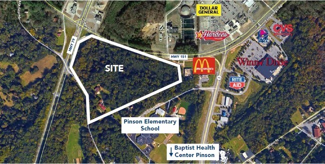
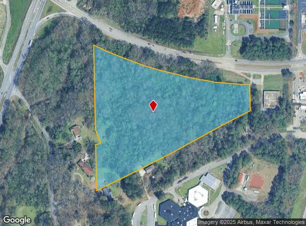
6551 Highway 151
09-00-30-3-000-018.008
COM SW COR OF SE 1/4 OF SW 1/4 SEC 30 TP 15 R 1W TH N 155 FT TO POB TH NE 1160 FT TH N 172.7 FT TH NWLY 1075 FT TH S 515 FT TH SELY 105 FT TH SWLY 31 FT TH S 330 FT TO POB
Vacantlandnec
Jefferson
AE
Alabama
01073C0233J
13 AC
2023
Fultondale
2024
Birmingham
011206
Birmingham-Hoover, AL
DEMOGRAPHICS near 6551 Highway 151
1 Mile
3 Mile
5 Mile
2024 Total Population
1,049
17,809
56,735
2029 Population
1,022
17,414
55,515
Pop Growth 2024-2029
(2.57%)
(2.22%)
(2.15%)
Average Age
41
37
37
2024 Total Households
402
6,545
21,191
HH Growth 2024-2029
(2.74%)
(2.25%)
(2.20%)
Median Household Inc
$68,785
$54,502
$52,569
Avg Household Size
2.50
2.70
2.60
2024 Avg HH Vehicles
2.00
2.00
2.00
Median Home Value
$173,369
$156,511
$152,623
Median Year Built
1979
1982
1979
Nearby Places
Map Layers
Map Styles
 Street
 Aerial
- Restaurants
- Banks
- Shops
- Fitness
- Groceries
PUBLIC TRANSPORTATION
AIRPORT
Birmingham-Shuttlesworth International
DRIVE
WALK
Distance
Birmingham-Shuttlesworth International
23 min
13.4 mi
Freight Ports
Port of Mobile
DRIVE
WALK
Distance
Port of Mobile
304 min
272.1 mi
SALE & LEASE HISTORY
LISTING DATE
SALE/LEASE

Sep 24, 2016
For Sale
Nearby Properties
Address
Land Use
TOTAL SIZE
Lot Size
Zoning
Address
Land Use
TOTAL SIZE
Lot Size
Zoning
192,596 SF
13.79 AC
CR5
Address
Land Use
TOTAL SIZE
Lot Size
Zoning
531,808 SF
23.96 AC
I4&A
Address
Land Use
TOTAL SIZE
Lot Size
Zoning
502,302 SF
24.61 AC
I4&A
Address
Land Use
TOTAL SIZE
Lot Size
Zoning
117,342 SF
36 AC
I
Address
Land Use
TOTAL SIZE
Lot Size
Zoning
81,817 SF
9.30 AC
C1
Address
Land Use
TOTAL SIZE
Lot Size
Zoning
56,504 SF
2 AC
C1-C
Address
Land Use
TOTAL SIZE
Lot Size
Zoning
63,736 SF
11 AC
I
Address
Land Use
TOTAL SIZE
Lot Size
Zoning
113,175 SF
21.85 AC
I2
Address
Land Use
TOTAL SIZE
Lot Size
Zoning
61,472 SF
18.84 AC
INT-
Address
Land Use
TOTAL SIZE
Lot Size
Zoning
329,728 SF
29.40 AC
I4&A
Address
Land Use
TOTAL SIZE
Lot Size
Zoning
58,816 SF
2.98 AC
C1
Address
Land Use
TOTAL SIZE
Lot Size
Zoning
40,535 SF
4 AC
INST
Address
Land Use
TOTAL SIZE
Lot Size
Zoning
34,755 SF
1.28 AC
INST
Address
Land Use
TOTAL SIZE
Lot Size
Zoning
148,564 SF
11 AC
I2
Address
Land Use
TOTAL SIZE
Lot Size
Zoning
78,024 SF
10.90 AC
I-1
Address
Land Use
TOTAL SIZE
Lot Size
Zoning
78,112 SF
4.64 AC
R4
Address
Land Use
TOTAL SIZE
Lot Size
Zoning
20,625 SF
5.30 AC
A1IN
Address
Land Use
TOTAL SIZE
Lot Size
Zoning
12,871 SF
2.52 AC
C1
Address
Land Use
TOTAL SIZE
Lot Size
Zoning
12,683 SF
0.54 AC
C1
Address
Land Use
TOTAL SIZE
Lot Size
Zoning
82 AC
R2
Address
Land Use
TOTAL SIZE
Lot Size
Zoning
19,512 SF
7.10 AC
I1
Address
Land Use
TOTAL SIZE
Lot Size
Zoning
5,458 SF
2.42 AC
C1
Address
Land Use
TOTAL SIZE
Lot Size
Zoning
11,100 SF
1.40 AC
C1
Address
Land Use
TOTAL SIZE
Lot Size
Zoning
19,284 SF
3.30 AC
CO&I
Address
Land Use
TOTAL SIZE
Lot Size
Zoning
8,230 SF
3.80 AC
I1
Address
Land Use
TOTAL SIZE
Lot Size
Zoning
800 SF
2.77 AC
C1 R
Address
Land Use
TOTAL SIZE
Lot Size
Zoning
10,504 SF
1.61 AC
I-1
Address
Land Use
TOTAL SIZE
Lot Size
Zoning
13,372 SF
1.40 AC
I1-C
Address
Land Use
TOTAL SIZE
Lot Size
Zoning
86,320 SF
7.07 AC
C1-I
Address
Land Use
TOTAL SIZE
Lot Size
Zoning
The World's #1 Commercial Real Estate Marketplace
Connect with us
© 2025 CoStar Group
The information above has been obtained from sources believed reliable. While we do not doubt its accuracy we have not verified it and make no guarantee, warranty or representation about it. It is your responsibility to independently confirm its accuracy and completeness. Any projections, opinions, assumptions, or estimates used are for example only and do not represent the current or future performance of the property. The value of this transaction to you depends on tax and other factors which should be evaluated by your tax, financial, and legal advisors. You and your advisors should conduct a careful, independent investigation of the property to determine to your satisfaction the suitability of the property for your needs.