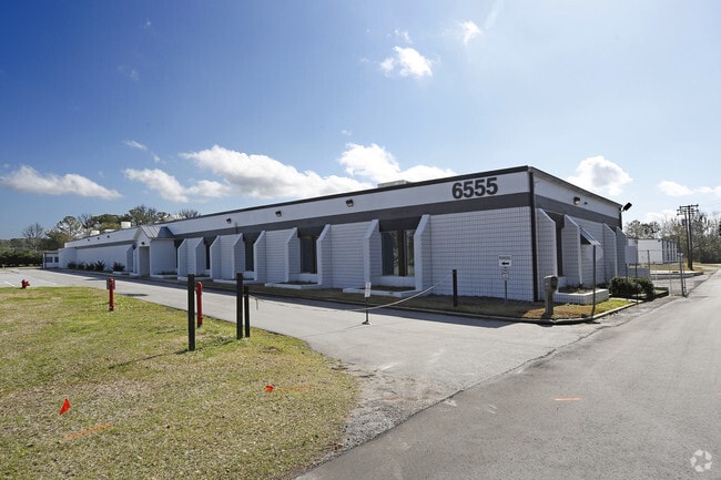
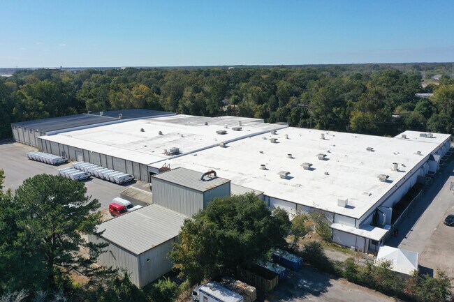
Property Record
6555 Fain St, Charleston, SC 29406
Current Lease Availabilities
NEARBY LISTINGS FOR SALE OR LEASE
Property Detail
6555 Fain St
475-00-00-007
Estate Of Willard Wilfred Wild
Warehouse
DESCRIPTION -PARCELS 1 AND 2 SITE NAME -OFF
X
Charleston
45019C0295K
South Carolina
2025
8 AC
2024
North Charleston
003105
Charleston/N Charleston
167,100 SF
Charleston-North Charleston, SC
DEMOGRAPHICS near 6555 Fain St
1 mile
3 mile
5 mile
2024 Total Population
6,506
54,436
137,286
2029 Population
7,051
59,982
150,375
Pop Growth 2024-2029
+ 8.38%
+ 10.19%
+ 9.53%
Average Age
35
36
37
2024 Total Households
2,538
21,387
53,801
HH Growth 2024-2029
+ 8.27%
+ 10.00%
+ 9.35%
Median Household Inc
$33,969
$53,309
$55,115
Avg Household Size
2.50
2.40
2.40
2024 Avg HH Vehicles
1.00
2.00
2.00
Median Home Value
$98,870
$224,468
$218,691
Median Year Built
1982
1986
1986
Nearby Places
Map Layers
Map Styles
 Street
 Aerial
Transit
 Traffic
 Biking
Places
Listings with unknown addresses are not visible on the map
- Restaurants
- Banks
- Shops
- Fitness
- Groceries
PUBLIC TRANSPORTATION
COMMUTER RAIL
Charleston Amtrak Station (Palmetto - Amtrak, Silver Meteor - Amtrak)
Drive
Walk
Distance
Charleston Amtrak Station (Palmetto - Amtrak, Silver Meteor - Amtrak)
6 min
4.1 mi
AIRPORT
Charleston AFB/International
Drive
Walk
Distance
Charleston AFB/International
15 min
5.0 mi
Freight Ports
North Charleston Terminal
Drive
Walk
Distance
North Charleston Terminal
6 min
3.7 mi
Nearby Properties
Address
Land Use
TOTAL SIZE
Lot Size
Zoning
Address
Land Use
TOTAL SIZE
Lot Size
Zoning
313,920 SF
23.09 AC
HANAHAN -
Address
Land Use
TOTAL SIZE
Lot Size
Zoning
2,917 SF
11.76 AC
HANAHAN -
Address
Land Use
TOTAL SIZE
Lot Size
Zoning
10,172 SF
12.76 AC
Address
Land Use
TOTAL SIZE
Lot Size
Zoning
7,200 SF
8.73 AC
Address
Land Use
TOTAL SIZE
Lot Size
Zoning
197,100 SF
34.14 AC
HANAHAN -
Address
Land Use
TOTAL SIZE
Lot Size
Zoning
64,584 SF
10.92 AC
HANAHAN -
Address
Land Use
TOTAL SIZE
Lot Size
Zoning
137,576 SF
5 AC
HANAHAN -
Address
Land Use
TOTAL SIZE
Lot Size
Zoning
68,655 SF
9.48 AC
Address
Land Use
TOTAL SIZE
Lot Size
Zoning
4,320 SF
8.14 AC
HANAHAN -
Address
Land Use
TOTAL SIZE
Lot Size
Zoning
36,882 SF
5.80 AC
HANAHAN -
Address
Land Use
TOTAL SIZE
Lot Size
Zoning
105,666 SF
8.25 AC
Address
Land Use
TOTAL SIZE
Lot Size
Zoning
390,180 SF
20.76 AC
HANAHAN -
Address
Land Use
TOTAL SIZE
Lot Size
Zoning
36,912 SF
6.19 AC
HANAHAN -
Address
Land Use
TOTAL SIZE
Lot Size
Zoning
21,364 SF
7.71 AC
Address
Land Use
TOTAL SIZE
Lot Size
Zoning
92,800 SF
15.24 AC
HANAHAN -
Address
Land Use
TOTAL SIZE
Lot Size
Zoning
3,672 SF
3.62 AC
HANAHAN -
Address
Land Use
TOTAL SIZE
Lot Size
Zoning
10,560 SF
7.50 AC
Address
Land Use
TOTAL SIZE
Lot Size
Zoning
68,208 SF
21.38 AC
HANAHAN -
Address
Land Use
TOTAL SIZE
Lot Size
Zoning
7,176 SF
3.55 AC
HANAHAN -
Address
Land Use
TOTAL SIZE
Lot Size
Zoning
101,011 SF
6.58 AC
Address
Land Use
TOTAL SIZE
Lot Size
Zoning
54,449 SF
10.56 AC
HANAHAN -
Address
Land Use
TOTAL SIZE
Lot Size
Zoning
199,300 SF
13.28 AC
Address
Land Use
TOTAL SIZE
Lot Size
Zoning
48,885 SF
5.02 AC
Address
Land Use
TOTAL SIZE
Lot Size
Zoning
126,385 SF
13.45 AC
Address
Land Use
TOTAL SIZE
Lot Size
Zoning
210,664 SF
8.87 AC
HANAHAN -
Address
Land Use
TOTAL SIZE
Lot Size
Zoning
9,691 SF
10.34 AC
Address
Land Use
TOTAL SIZE
Lot Size
Zoning
2,280 SF
27.93 AC
HANAHAN -
Address
Land Use
TOTAL SIZE
Lot Size
Zoning
133.75 AC
MUC_DC
Address
Land Use
TOTAL SIZE
Lot Size
Zoning
51,821 SF
6.14 AC
HANAHAN -
Address
Land Use
TOTAL SIZE
Lot Size
Zoning
14,775 SF
1.52 AC
HANAHAN -
The World's #1 Commercial Real Estate Marketplace
Connect with us
© 2026 CoStar Group
The information above has been obtained from sources believed reliable. While we do not doubt its accuracy we have not verified it and make no guarantee, warranty or representation about it. It is your responsibility to independently confirm its accuracy and completeness. Any projections, opinions, assumptions, or estimates used are for example only and do not represent the current or future performance of the property. The value of this transaction to you depends on tax and other factors which should be evaluated by your tax, financial, and legal advisors. You and your advisors should conduct a careful, independent investigation of the property to determine to your satisfaction the suitability of the property for your needs.