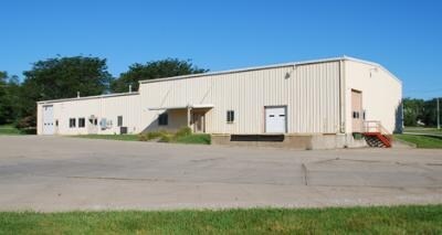
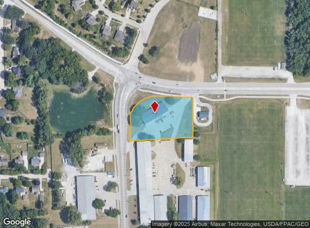
Property Record
6555 Nw Beaver Dr, Johnston, IA 50131

NEARBY LISTINGS FOR SALE OR LEASE
Property Detail
6555 Nw Beaver Dr
Des Moines-West Des Moines, IA
Lower Beaver Plat 2
24100828022001
-EX BEG SW COR LOT 2 THN N 86.02F NELY ALNG CRV 69.56F S 64.02F S 89.87F S 58.8F TO W LN LOT 1 THN N 58.57F TO POB- LOT 2 LESS ROW EAS COM NE COR LOT 2 THN NW ALNG S ROW LN NW 66TH AVE 7.22F TO POB WLY ALNG CRV 129.58F E 26.28F SE 103.24F TO POB LOWE
Warehouse
Polk
AE
Iowa
19153C0195F
2
2024
1.96 AC
2025
Western Suburbs
011406
Des Moines
9,360 SF
DEMOGRAPHICS near 6555 Nw Beaver Dr
1 Mile
3 Mile
5 Mile
2024 Total Population
3,510
28,325
134,792
2029 Population
3,642
29,385
140,065
Pop Growth 2024-2029
+ 3.76%
+ 3.74%
+ 3.91%
Average Age
39
39
38
2024 Total Households
1,341
10,986
53,236
HH Growth 2024-2029
+ 4.03%
+ 4.04%
+ 4.08%
Median Household Inc
$80,852
$86,080
$81,541
Avg Household Size
2.60
2.50
2.40
2024 Avg HH Vehicles
2.00
2.00
2.00
Median Home Value
$267,142
$277,122
$241,323
Median Year Built
1996
1994
1984
Nearby Places
Map Layers
Map Styles
 Street
 Aerial
- Restaurants
- Banks
- Shops
- Fitness
- Groceries
PUBLIC TRANSPORTATION
AIRPORT
Des Moines International
DRIVE
WALK
Distance
Des Moines International
25 min
12.2 mi
Nearby Properties
Address
Land Use
TOTAL SIZE
Lot Size
Zoning
Address
Land Use
TOTAL SIZE
Lot Size
Zoning
627,104 SF
40.09 AC
Address
Land Use
TOTAL SIZE
Lot Size
Zoning
197,658 SF
15.91 AC
Address
Land Use
TOTAL SIZE
Lot Size
Zoning
184,658 SF
14.61 AC
Address
Land Use
TOTAL SIZE
Lot Size
Zoning
166,160 SF
11.88 AC
Address
Land Use
TOTAL SIZE
Lot Size
Zoning
287,228 SF
27.32 AC
A-R
Address
Land Use
TOTAL SIZE
Lot Size
Zoning
307,734 SF
23.59 AC
R-3
Address
Land Use
TOTAL SIZE
Lot Size
Zoning
71,938 SF
8.23 AC
C-O
Address
Land Use
TOTAL SIZE
Lot Size
Zoning
101,592 SF
7.79 AC
PUD
Address
Land Use
TOTAL SIZE
Lot Size
Zoning
141,377 SF
3.16 AC
Address
Land Use
TOTAL SIZE
Lot Size
Zoning
363,736 SF
25.79 AC
M-1
Address
Land Use
TOTAL SIZE
Lot Size
Zoning
188,453 SF
14.20 AC
R-3
Address
Land Use
TOTAL SIZE
Lot Size
Zoning
143,831 SF
16.12 AC
PUD
Address
Land Use
TOTAL SIZE
Lot Size
Zoning
56,478 SF
5.86 AC
Address
Land Use
TOTAL SIZE
Lot Size
Zoning
130,686 SF
1.23 AC
Address
Land Use
TOTAL SIZE
Lot Size
Zoning
203,062 SF
17.82 AC
C-2
Address
Land Use
TOTAL SIZE
Lot Size
Zoning
92,392 SF
12.40 AC
C-2
Address
Land Use
TOTAL SIZE
Lot Size
Zoning
95,400 SF
4.40 AC
PUD
Address
Land Use
TOTAL SIZE
Lot Size
Zoning
53,827 SF
5.72 AC
Address
Land Use
TOTAL SIZE
Lot Size
Zoning
80,559 SF
4.50 AC
Address
Land Use
TOTAL SIZE
Lot Size
Zoning
84,941 SF
2.66 AC
Address
Land Use
TOTAL SIZE
Lot Size
Zoning
51,170 SF
7.86 AC
C-2
Address
Land Use
TOTAL SIZE
Lot Size
Zoning
139,947 SF
7.21 AC
R-4
Address
Land Use
TOTAL SIZE
Lot Size
Zoning
39,312 SF
13.08 AC
Address
Land Use
TOTAL SIZE
Lot Size
Zoning
71,984 SF
7.67 AC
Address
Land Use
TOTAL SIZE
Lot Size
Zoning
20,580 SF
5.37 AC
PUD
Address
Land Use
TOTAL SIZE
Lot Size
Zoning
137,340 SF
9.85 AC
CH
Address
Land Use
TOTAL SIZE
Lot Size
Zoning
260,258 SF
21.50 AC
Address
Land Use
TOTAL SIZE
Lot Size
Zoning
49,196 SF
7.04 AC
R-2
Address
Land Use
TOTAL SIZE
Lot Size
Zoning
44,726 SF
122.63 AC
GF
The World's #1 Commercial Real Estate Marketplace
Connect with us
© 2025 CoStar Group
The information above has been obtained from sources believed reliable. While we do not doubt its accuracy we have not verified it and make no guarantee, warranty or representation about it. It is your responsibility to independently confirm its accuracy and completeness. Any projections, opinions, assumptions, or estimates used are for example only and do not represent the current or future performance of the property. The value of this transaction to you depends on tax and other factors which should be evaluated by your tax, financial, and legal advisors. You and your advisors should conduct a careful, independent investigation of the property to determine to your satisfaction the suitability of the property for your needs.