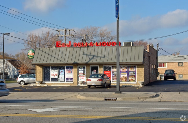
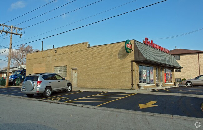
Property Record
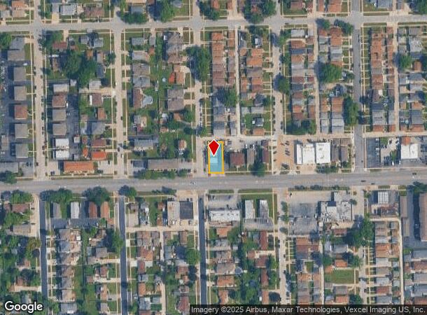
6556 W 79Th St, Burbank, IL 60459
NEARBY LISTINGS FOR SALE OR LEASE
Property Detail
6556 W 79Th St
19-30-407-029-0000
Frederick H Bartletts 1St Add
Commercialbuilding
Cook
X
Illinois
17031C0606J
0.16 AC
2023
Near South Cook
2024
Chicago
820901
Chicago-Naperville-Elgin, IL-IN-WI
2,440 SF
DEMOGRAPHICS near 6556 W 79Th St
1 Mile
3 Mile
5 Mile
2024 Total Population
15,952
145,922
403,790
2029 Population
15,392
140,956
388,444
Pop Growth 2024-2029
(3.51%)
(3.40%)
(3.80%)
Average Age
40
39
39
2024 Total Households
5,306
50,101
137,230
HH Growth 2024-2029
(3.86%)
(3.72%)
(4.02%)
Median Household Inc
$63,360
$65,643
$66,628
Avg Household Size
2.90
2.80
2.80
2024 Avg HH Vehicles
2.00
2.00
2.00
Median Home Value
$243,460
$238,499
$232,781
Median Year Built
1964
1963
1961
Nearby Places
Map Layers
Map Styles
 Street
 Aerial
- Restaurants
- Banks
- Shops
- Fitness
- Groceries
PUBLIC TRANSPORTATION
COMMUTER RAIL
Chicago Ridge Station (SouthWest Service - Northeast Illinois Regional Commuter Railroad (Metra))
DRIVE
WALK
Distance
Chicago Ridge Station (SouthWest Service - Northeast Illinois Regional Commuter Railroad (Metra))
9 min
3.4 mi
Oak Lawn Station (SouthWest Service - Northeast Illinois Regional Commuter Railroad (Metra))
DRIVE
WALK
Distance
Oak Lawn Station (SouthWest Service - Northeast Illinois Regional Commuter Railroad (Metra))
9 min
3.9 mi
AIRPORT
Chicago Midway International
DRIVE
WALK
Distance
Chicago Midway International
10 min
4.6 mi
Chicago O'Hare International
DRIVE
WALK
Distance
Chicago O'Hare International
58 min
28.3 mi
Nearby Properties
Address
Land Use
TOTAL SIZE
Lot Size
Zoning
Address
Land Use
TOTAL SIZE
Lot Size
Zoning
Address
Land Use
TOTAL SIZE
Lot Size
Zoning
2,155,128 SF
63.23 AC
PMD13
Address
Land Use
TOTAL SIZE
Lot Size
Zoning
72,090 SF
10.19 AC
Address
Land Use
TOTAL SIZE
Lot Size
Zoning
798,998 SF
B3-2
Address
Land Use
TOTAL SIZE
Lot Size
Zoning
124,324 SF
11.26 AC
Address
Land Use
TOTAL SIZE
Lot Size
Zoning
266,580 SF
29.50 AC
Address
Land Use
TOTAL SIZE
Lot Size
Zoning
252,973 SF
11.68 AC
Address
Land Use
TOTAL SIZE
Lot Size
Zoning
51,762 SF
4 AC
Address
Land Use
TOTAL SIZE
Lot Size
Zoning
191,763 SF
15.63 AC
Address
Land Use
TOTAL SIZE
Lot Size
Zoning
292,978 SF
22.31 AC
Address
Land Use
TOTAL SIZE
Lot Size
Zoning
61,003 SF
68.78 AC
Address
Land Use
TOTAL SIZE
Lot Size
Zoning
111,830 SF
2.16 AC
Address
Land Use
TOTAL SIZE
Lot Size
Zoning
198,190 SF
15 AC
Address
Land Use
TOTAL SIZE
Lot Size
Zoning
139,493 SF
9.06 AC
PD 965
Address
Land Use
TOTAL SIZE
Lot Size
Zoning
134,078 SF
17.31 AC
Address
Land Use
TOTAL SIZE
Lot Size
Zoning
102,534 SF
3.87 AC
Address
Land Use
TOTAL SIZE
Lot Size
Zoning
397,288 SF
10.18 AC
Address
Land Use
TOTAL SIZE
Lot Size
Zoning
148,474 SF
17.68 AC
Address
Land Use
TOTAL SIZE
Lot Size
Zoning
93,438 SF
3.13 AC
Address
Land Use
TOTAL SIZE
Lot Size
Zoning
86,703 SF
3.37 AC
Address
Land Use
TOTAL SIZE
Lot Size
Zoning
367,185 SF
25 AC
Address
Land Use
TOTAL SIZE
Lot Size
Zoning
28,406 SF
1.42 AC
Address
Land Use
TOTAL SIZE
Lot Size
Zoning
256,416 SF
9.07 AC
Address
Land Use
TOTAL SIZE
Lot Size
Zoning
101,034 SF
1.92 AC
Address
Land Use
TOTAL SIZE
Lot Size
Zoning
90,808 SF
3.27 AC
Address
Land Use
TOTAL SIZE
Lot Size
Zoning
470,160 SF
23.66 AC
Address
Land Use
TOTAL SIZE
Lot Size
Zoning
127,197 SF
10.43 AC
Address
Land Use
TOTAL SIZE
Lot Size
Zoning
8.32 AC
Address
Land Use
TOTAL SIZE
Lot Size
Zoning
202,309 SF
13.02 AC
Address
Land Use
TOTAL SIZE
Lot Size
Zoning
45,196 SF
1.28 AC
The World's #1 Commercial Real Estate Marketplace
Connect with us
© 2025 CoStar Group
The information above has been obtained from sources believed reliable. While we do not doubt its accuracy we have not verified it and make no guarantee, warranty or representation about it. It is your responsibility to independently confirm its accuracy and completeness. Any projections, opinions, assumptions, or estimates used are for example only and do not represent the current or future performance of the property. The value of this transaction to you depends on tax and other factors which should be evaluated by your tax, financial, and legal advisors. You and your advisors should conduct a careful, independent investigation of the property to determine to your satisfaction the suitability of the property for your needs.