Property Record
6560 E Nc 150 Hwy, Sherrills Ford, NC 28673
NEARBY LISTINGS FOR SALE OR LEASE
Property Detail
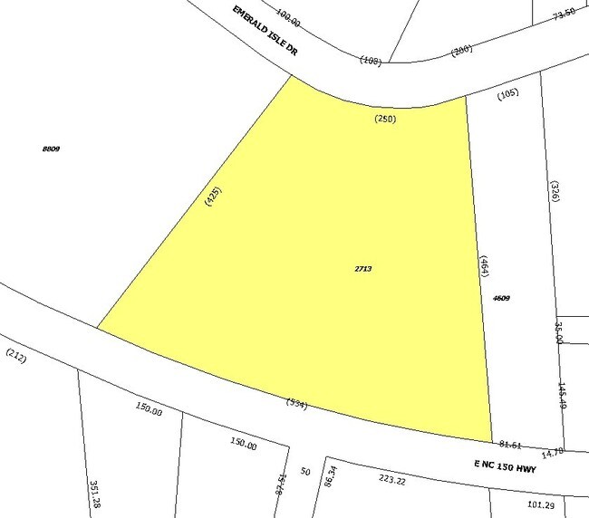
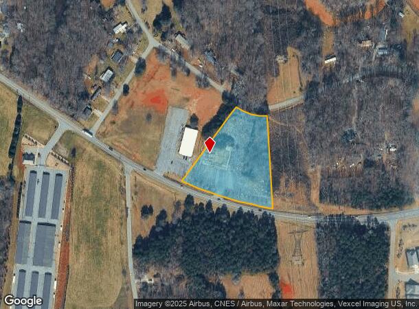
6560 E Nc 150 Hwy
Hickory-Lenoir-Morganton, NC
Cove Subdivision
3696076827130000
Catawba
Residentialnec
North Carolina
X
2.80 AC
3710369600J
Catawba County
8,145 SF
Charlotte
DEMOGRAPHICS near 6560 E Nc 150 Hwy
1 Mile
3 Mile
5 Mile
2024 Total Population
1,541
12,205
29,378
2029 Population
1,662
13,515
33,284
Pop Growth 2024-2029
+ 7.85%
+ 10.73%
+ 13.30%
Average Age
43
44
43
2024 Total Households
619
4,968
11,577
HH Growth 2024-2029
+ 7.75%
+ 10.73%
+ 13.21%
Median Household Inc
$74,471
$76,519
$91,675
Avg Household Size
2.50
2.40
2.50
2024 Avg HH Vehicles
2.00
2.00
2.00
Median Home Value
$279,194
$300,759
$391,772
Median Year Built
1998
1996
2000
Nearby Places
- Restaurants
- Banks
- Shops
- Fitness
- Groceries
PUBLIC TRANSPORTATION
AIRPORT
Charlotte/Douglas International
DRIVE
WALK
Distance
Charlotte/Douglas International
50 min
31.9 mi
Concord-Padgett Regional
DRIVE
WALK
Distance
Concord-Padgett Regional
49 min
35.3 mi
Freight Ports
North Charleston Terminal
DRIVE
WALK
Distance
North Charleston Terminal
261 min
227.7 mi
SALE & LEASE HISTORY
LISTING DATE
SALE/LEASE

Sep 25, 2025
For Lease
Nearby Properties
Address
Land Use
TOTAL SIZE
Lot Size
Zoning
Address
Land Use
TOTAL SIZE
Lot Size
Zoning
31,198 SF
26.01 AC
PD-CD
Address
Land Use
TOTAL SIZE
Lot Size
Zoning
1,288 SF
16.04 AC
PD-CD
Address
Land Use
TOTAL SIZE
Lot Size
Zoning
6,264 SF
24.64 AC
ELDD B-G
Address
Land Use
TOTAL SIZE
Lot Size
Zoning
60,860 SF
9.81 AC
PD-CD
Address
Land Use
TOTAL SIZE
Lot Size
Zoning
66,136 SF
18.10 AC
ELDD B-N &
Address
Land Use
TOTAL SIZE
Lot Size
Zoning
251,009 SF
20.46 AC
ELDD I-G
Address
Land Use
TOTAL SIZE
Lot Size
Zoning
71,150 SF
4.70 AC
PD-CD
Address
Land Use
TOTAL SIZE
Lot Size
Zoning
1,912 SF
31.99 AC
HC
Address
Land Use
TOTAL SIZE
Lot Size
Zoning
20,595 SF
2.65 AC
PD-CD
Address
Land Use
TOTAL SIZE
Lot Size
Zoning
3,571 SF
606.06 AC
R-80
Address
Land Use
TOTAL SIZE
Lot Size
Zoning
1,850 SF
36.60 AC
PD
Address
Land Use
TOTAL SIZE
Lot Size
Zoning
33,342 SF
9.79 AC
RC
Address
Land Use
TOTAL SIZE
Lot Size
Zoning
1,500 SF
11.02 AC
PD
Address
Land Use
TOTAL SIZE
Lot Size
Zoning
20,923 SF
2.83 AC
R-S CU
Address
Land Use
TOTAL SIZE
Lot Size
Zoning
2,000 SF
33.70 AC
R-30
Address
Land Use
TOTAL SIZE
Lot Size
Zoning
18,316 SF
3.61 AC
PD-CD
Address
Land Use
TOTAL SIZE
Lot Size
Zoning
12,000 SF
7.87 AC
ELDD B-G C
Address
Land Use
TOTAL SIZE
Lot Size
Zoning
14,736 SF
1.44 AC
HC
Address
Land Use
TOTAL SIZE
Lot Size
Zoning
37,999 SF
3.41 AC
HC
Address
Land Use
TOTAL SIZE
Lot Size
Zoning
6,889 SF
1.75 AC
PD-CD
Address
Land Use
TOTAL SIZE
Lot Size
Zoning
18,266 SF
9.73 AC
PD-CD
Address
Land Use
TOTAL SIZE
Lot Size
Zoning
10,768 SF
2.20 AC
HC
Address
Land Use
TOTAL SIZE
Lot Size
Zoning
24,548 SF
11.40 AC
ELDD B-G
Address
Land Use
TOTAL SIZE
Lot Size
Zoning
20,000 SF
2.60 AC
ELDD I-G
Address
Land Use
TOTAL SIZE
Lot Size
Zoning
60,000 SF
28.03 AC
ELDD I-G
Address
Land Use
TOTAL SIZE
Lot Size
Zoning
16,000 SF
3.12 AC
ELDD B-G
Address
Land Use
TOTAL SIZE
Lot Size
Zoning
30,048 SF
2 AC
I-G
Address
Land Use
TOTAL SIZE
Lot Size
Zoning
4,329 SF
1.43 AC
PD-CD
Address
Land Use
TOTAL SIZE
Lot Size
Zoning
41,606 SF
4.69 AC
PD
Address
Land Use
TOTAL SIZE
Lot Size
Zoning
12,352 SF
4.55 AC
HC
The World's #1 Commercial Real Estate Marketplace
Connect with us
© 2025 CoStar Group
The information above has been obtained from sources believed reliable. While we do not doubt its accuracy we have not verified it and make no guarantee, warranty or representation about it. It is your responsibility to independently confirm its accuracy and completeness. Any projections, opinions, assumptions, or estimates used are for example only and do not represent the current or future performance of the property. The value of this transaction to you depends on tax and other factors which should be evaluated by your tax, financial, and legal advisors. You and your advisors should conduct a careful, independent investigation of the property to determine to your satisfaction the suitability of the property for your needs.